
Artois facts for kids

Artois is a historical region located in northern France. It used to be a very important "province," which is like a large area or state within a country. Today, most of Artois is part of a French area called the Pas-de-Calais department.
This region covers an area of about 4,000 square kilometers (about 1,500 square miles). Around one million people live there. Some of the main cities in Artois include Arras, Saint-Omer, Lens, and Béthune.
Contents
What is Artois?
Artois is known for its rich history and its location. It's close to the border with Belgium and not far from the English Channel. This made it a very important place for trade and sometimes for battles throughout history.
Where is Artois Located?
The region of Artois is in the northern part of France. It's part of the Hauts-de-France administrative region today. Its position has always been key, connecting different parts of Europe.
A Brief Look at Artois's History
Artois has a long and interesting past. For many centuries, it was a "county," which means it was ruled by a count or countess. It was often connected to other powerful regions, like Flanders and the Duchy of Burgundy.
Becoming Part of France
Over time, Artois became part of the Kingdom of France. This happened after many changes in who ruled the area. Its history involves many different rulers and agreements that shaped its borders and its people.
Important Cities in Artois
- Arras: This is the historical capital of Artois. It's famous for its beautiful main squares and its rich history.
- Saint-Omer: An old city with a long history, known for its cathedral.
- Lens: This city became very important during the industrial age, especially for coal mining.
- Béthune: Another historic town with a central square and a tall belfry (bell tower).
Images for kids
-
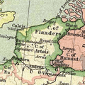
Location of the County of Artois in the 15th century

See also
 In Spanish: Artois para niños
