
Strait of Dover facts for kids
Quick facts for kids Dover Strait |
|
|---|---|
 View from France across the Strait of Dover towards the English coast View from France across the Strait of Dover towards the English coast |
|
| Location | North Sea–English Channel (Atlantic Ocean) |
| Coordinates | 51°00′N 1°27′E / 51.000°N 1.450°E |
| Type | Strait |
| Basin countries | France England |
| Min. width | 33.3 km (20.7 mi) |
| Average depth | 150 ft (46 m) |

The Strait of Dover (also called the Dover Strait) is a narrow stretch of water that connects the English Channel to the North Sea. It's the shortest distance between England and France.
This strait is at the eastern end of the English Channel. On a clear day, you can often see the coastline of the other country, and even some buildings, without needing binoculars!
Where is the narrowest part?
The narrowest part of the strait is between two specific points. On the English side, it's near a place called South Foreland. This is about 6 km (4 mi) northeast of Dover in Kent, England.
On the French side, the narrowest point is at Cap Gris Nez. This is a cape (a piece of land sticking out into the sea) near Calais in the département (like a county) of Pas-de-Calais, France.
The distance between these two points is only about 33 km (20 mi). This makes it the most popular route for people who want to swim across the English Channel!
Images for kids
-
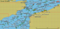
Automatic Identification System display showing ship traffic in the strait in 2006.
-
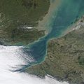
NASA Satellite image from December 2002.
-
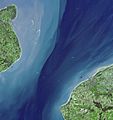
NASA Terra satellite image from March 2001.


See also
 In Spanish: Paso de Calais para niños
