South Foreland facts for kids
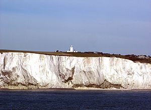
South Foreland is a tall cliff made of chalk on the coast of Kent in southeast England. From here, you can see far across the Strait of Dover. It is about 3 miles (4.8 km) northeast of Dover and 15 miles south of North Foreland. This spot is the closest part of Britain to mainland Europe, only about 20.6 miles (33.2 km) away.
Because it is so close to Europe, South Foreland was very important for defense. During the Second World War, coastal defenses and a radar station were built here. The area is located between the busy Port of Dover and the tricky Goodwin Sands sandbank. Its two lighthouses were very important for ships to find their way safely, before they stopped being used. Today, much of South Foreland is owned by the National Trust and is open for visitors. The Saxon Shore Way, a walking path along the Kent coast, goes through this area.
Contents
Lighthouses of South Foreland
South Foreland has two lighthouses. The lower lighthouse stopped being used in 1910. The upper lighthouse, which is now looked after by the National Trust, stopped guiding ships in 1988.
Geography and Geology of the Cliffs
South Foreland marks the southwestern edge of St Margaret's Bay, Kent, which is named after the village of St Margaret's at Cliffe. Geologically, it is like a twin to Cap Blanc Nez (which means "white nose cape") in France. These two chalk cliffs are the land ends of the Strait of Dover. The chalk rock layer here was important for deciding where to dig the Channel Tunnel. Scientists believe that a lot of the land here was worn away by rivers, like an ancient Rhine River, and other rivers from the southern North Sea that flowed through the Strait of Dover.
South Foreland During World War II
During the Second World War, South Foreland had a Chain Home radar station. This was similar to the tall towers you can still see at Swingate transmitting station, east of Dover. Radar stations helped detect enemy aircraft and ships.
The South Foreland Battery
The South Foreland battery was a group of coastal artillery guns. It had four large 9.2-inch guns, along with many bunkers and places to store ammunition. This battery was located northeast of the lighthouse, on the road to St Margaret's. After the war, the site was cleared, but some traces can still be found, though they are now covered by plants.
The strong gun positions were built into the cliff very quickly, starting in December 1940. The first gun arrived in March 1941. One of the guns was test-fired in November 1941.
The Channel Dash
On February 12, 1942, three large German warships – the Gneisenau, Scharnhorst, and Prinz Eugen – tried to sail from Brest, France to Germany. This event is known as the Channel Dash. The radar at South Foreland started tracking these ships as they moved up the English Channel towards Cap Gris Nez.
At 12:19 PM, the South Foreland battery fired its first shots. Visibility was poor, only about five miles, so the gunners could not see where their shells landed. However, the radar showed the ships moving in a zig-zag pattern, so the battery fired all its guns. They fired 33 shells at the German ships, which were moving fast, at about 30 kn (35 mph; 56 km/h). Later, the Germans said that all the shells had missed.
By the end of the war, the four guns at South Foreland had fired 2,248 shells. Most of these were fired in the months around the Normandy landings. The coastal batteries around Dover, including South Foreland, sank 28 enemy ships. This made it too risky for the German surface fleet to try another Channel Dash.
 | Leon Lynch |
 | Milton P. Webster |
 | Ferdinand Smith |


