
Goodwin Sands facts for kids
Lua error in Module:Location_map at line 420: attempt to index field 'wikibase' (a nil value).
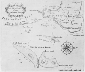
The Goodwin Sands is a long sandbank located at the southern end of the North Sea. It stretches about 10 kilometers (6 miles) off the coast of Deal in Kent, England. This area is made of fine sand, about 25 meters (82 feet) deep, resting on a chalk platform. This chalk is part of the same geological feature as the famous White Cliffs of Dover.
The sandbanks can be seen above the water at low tide, but most of the time they are underwater. Strong tides and currents are always moving the sand around, which makes the area very tricky for ships.
More than 2,000 ships are thought to have been wrecked on the Goodwin Sands. This is because the sands are very close to the main shipping lanes through the Straits of Dover. The few miles between the sands and the coast offer a safe place for ships to anchor during bad weather. This area is known as The Downs. Because of the dangers, the Goodwin Sands, which also include Brake Bank, are marked by many lightvessels (special ships with lights) and buoys to warn sailors.
Many famous shipwrecks have happened here. These include HMS Stirling Castle in 1703 and the Dutch ship VOC ship Rooswijk in 1740. The South Goodwin Lightship also broke free during a storm in 1954. Several naval battles have been fought nearby, such as the Battles of the Goodwin Sands in 1602 and 1652, and the Battle of Dover Strait in 1917.
When hovercrafts used to run from Pegwell Bay, Ramsgate, they sometimes made trips over the Sands. This was a place where regular boats could not safely go.
Southeast of Goodwin Sands, you can find the Sandettie Bank.
Contents


The East Goodwin lightship is positioned at the farthest end of the Sands. Its job is to warn ships about the danger. It is the only lightship left out of the five that once guarded the sands.
In the past, three lighthouses on the Kent mainland helped guide ships around the sands. Today, only North Foreland lighthouse is still working. South Foreland lighthouse, also known as South Foreland Upper, is now owned by the National Trust. This lighthouse used to work with the nearby South Foreland Low lighthouse, also called Old St Margaret's Lighthouse. When these two South Foreland lights lined up, ship crews knew they had reached the southernmost point of the sandbank.
When the Goodwin Sands shifted, the South Foreland Low lighthouse was no longer needed. It was replaced by the South Goodwin Lightvessel. The first of these lightships was bombed by the Germans and sank in 1940. The next one, LV90, sank in 1954 during a huge storm. You can still see the wreck of this lightship at low tide. The last South Goodwin Lightvessel was removed in 2006.
The Legend of Lomea Island
For a long time, people believed that the Goodwin Sands were once a fertile island called Lomea. This idea came from a geologist named Charles Lyell in 1817. He thought the sands were the remains of a clay island, similar to the Isle of Sheppey.
Some old stories say that Lomea was known to the Romans as Infera Insula, meaning "Low Island." It was supposedly owned by Godwin, Earl of Wessex, in the 11th century, which is why the Sands are named after him. The legend says that when Earl Godwin lost favor, the land was given to St. Augustine's Abbey, Canterbury. The abbot (head of the abbey) supposedly failed to maintain the sea walls, leading to the island's destruction. Some say this happened during a big storm in 1099.
However, the island is not mentioned in the Domesday Book, which was a survey of England completed in 1086. This suggests that if Lomea existed, it might have been flooded before that time. The name "Lomea" first appeared in a book published in 1590, but it didn't give any proof that the island existed.
Today, most geologists believe that the island of Lomea probably never existed as an island in recorded history. The area now covered by the sands and sea was once dry land, but the Strait of Dover formed thousands of years ago, long before humans started writing history.
Another idea about the name "Goodwin" is that it comes from an old Anglo-Saxon phrase, gōd wine, which means "good friend." Sailors might have used this name ironically because the sands are so dangerous. Or, it could be because ships could find shelter from storms in the deep water between the sands and the coast, known as The Roads.
Famous Events and Shipwrecks
17th Century Disasters
- In October 1624, a huge storm caused many ships to sink in The Downs. One ship, the Antelope, was pushed onto the Sands and lost its rudder. Luckily, it was saved, but another ship nearby, the Dolphin, sank completely.
- In 1630, the Stella sank in a storm off Goodwin Sands. Nearly 300 Scottish and English soldiers drowned.
- In 1690, HMS Vanguard, a large warship, hit the Sands but was pulled off by local boatmen.
18th and 19th Century Tragedies
The Great Storm of 1703 In the great storm of 1703, at least 13 warships and 40 merchant ships were wrecked in The Downs. Over 2,100 lives were lost. Despite the chaos, brave boatmen from Deal rescued 200 men.
Some of the naval ships lost included:
- HMS Northumberland and HMS Restoration, both sank with everyone on board.
- HMS Stirling Castle, a 70-gun warship.
- HMS Mary, which sank with 343 men.
The Rooswijk (1740) The Dutch merchant ship "Rooswijk" was on its way to the Cape of Good Hope and the East Indies when it sank on the Goodwin Sands in a storm on January 8, 1740. All 250 sailors, soldiers, and passengers on board were lost. The muddy environment preserved the wreck for a long time. However, shifting tides started to uncover it, leading to its salvage in 2017.
The Lady Lovibond (1748) A famous legend tells of the Lady Lovibond, which supposedly wrecked on the Goodwin Sands on February 13, 1748. All hands were lost. The story says she reappears every fifty years as a ghost ship. However, there are no official records of this shipwreck in newspapers or shipping logs from that time.
The Admiral Gardner (1809) Admiral Gardner was wrecked in January 1809. It was carrying many copper coins belonging to Matthew Boulton. The wreck was found in 1984, and some coins were recovered in 1985.
The Mary White (1851) The brig Mary White was wrecked on the Sands in a storm in 1851. The lifeboat from Broadstairs rescued seven of her crew.
The Violet (1857) The mail steamer SS The Violet was pushed onto the sands during a storm on January 5, 1857. Seventeen crew members, a mail guard, and one passenger died.
20th Century Incidents
- The Belgian cargo ship SS Cap Lopez was wrecked on the sands in 1907.
- HMT Etoile Polaire, a naval trawler, was sunk by a mine during the First World War on December 3, 1915.

- Two ships named SS Mahratta ran aground on the Sands, one in 1909 and another in 1939.
- The passenger ship SS Chusan crashed into the freighter Prospector near the Sands in June 1953. The Chusan was badly damaged and almost sank.
- The Radio Caroline vessel MV Ross Revenge drifted onto the Sands in November 1991. This event marked the end of offshore pirate radio in Britain.
21st Century Discoveries
On June 10, 2013, a Dornier Do 17 Z2 airplane was lifted from Goodwin Sands. This German bomber had made an emergency landing in the sea over the Sands on August 26, 1940, during a bombing raid. Two of the four crew members died on impact, and the others became POWs. The Dornier was found in September 2008. Plans were made to recover it because it is one of only two surviving aircraft of its kind.
The recovery started in May 2013. The plane was finally lifted on June 10, 2013. It is believed to have been shot down by a Boulton Paul Defiant fighter plane during a battle in 1940.
Future Plans: Port or Airport?
For many years, there have been ideas about building a large port or even an airport on the Goodwin Sands. In 1968, a proposal was made to create a deep-water port by reclaiming (filling in) the Sands. In 1985, consultants suggested building an International Freeport (a special trade zone) with a two-runway airport on three reclaimed islands on the sands. Even in 2003, this idea was still being considered. One big advantage is that it would be far from homes, allowing planes to take off and land 24 hours a day without disturbing people.
In 2012, the Goodwin Sands were again suggested as a possible location for a huge, 24-hour airport for the UK. Engineering firms believe that building up to five runways offshore at Goodwin Airport would be the best solution. They say it would have the "least negative impact" compared to other airport expansion plans. This is because there are no special environmental protections on the Goodwin Sands, and the runways could be designed to avoid flying over the coast.
Cricket on the Sands
In the summer of 1824, Captain K. Martin, the Harbourmaster at Ramsgate, organized the first known cricket match on the Goodwin Sands. It was played at low tide when the sands were exposed. An annual cricket match was played on the sands until 2003. In 2006, a film crew trying to recreate this for the BBC show Coast had to be rescued by the Ramsgate lifeboat when they got into trouble.
When the Royal Marines School of Music was based in Deal, they also played a game of cricket on a suitable day each summer.
Athletics on the Sands
On June 23, 1994, Deal Striders organized a 1-mile race on the Goodwin Sands. This race was held in memory of the late Cliff Temple, a famous runner. About 100 athletes and spectators traveled from Dover on a hovercraft and landed on the sands at low tide. A one-mile course was set up, and the race began. Despite a strong wind, Matt de Freitas won the event, with London Marathon winner Mike Gratton coming in second.

|
