
Auvergne-Rhône-Alpes facts for kids
Quick facts for kids Auvergne-Rhône-Alpes |
|||
| Region | |||
|
|||
| Country | |||
|---|---|---|---|
| Préfecture | Lyon | ||
| - coordinates | 45°45′35″N 4°50′32″E / 45.75972°N 4.84222°E | ||
| Area | 69,711.2 km² (26,916 sq mi) | ||
| Population | 7,820,966 (2014) | ||
| Density | 112 /km² (290 /sq mi) | ||
| Subdivisions | 12 departments 39 arrondissements 242 cantons 4,112 communes |
||
| President | Laurent Wauquiez | ||
| Timezone | CET (UTC+1) | ||
| - summer (DST) | CEST (UTC+2) | ||
| INSEE code | FR-84 | ||


Auvergne-Rhône-Alpes is a large area in France. It is a special administrative region that was created on January 1, 2016. This happened when two older regions, Auvergne and Rhône-Alpes, joined together.
You can find this region in the central and eastern parts of southern France. Its main city and capital is Lyon.
Contents
Exploring Auvergne-Rhône-Alpes Geography
The Auvergne-Rhône-Alpes region is the third biggest region in Metropolitan France. It covers about 69,711 square kilometers (26,916 square miles).
It shares borders with five other French regions. These are Bourgogne-Franche-Comté to the north, Centre-Val de Loire to the northwest, Nouvelle-Aquitaine to the west, Occitanie to the southwest, and Provence-Alpes-Côte d'Azur to the southeast.
The region also borders two other countries: Italy to the east and Switzerland to the northeast.
The landscape here is very diverse! You'll find the Massif Central mountain range in the west. To the east, there are the mighty Alps. Between these two mountain ranges, the Rhône river flows through a wide valley. Part of the Ain department is also covered by the Jura Mountains.
The capital city, Lyon, is about 465 kilometers (289 miles) southwest of Paris. Paris is the capital of France.
Major Rivers in the Region
Auvergne-Rhône-Alpes has two main river systems. These rivers flow into either the Atlantic Ocean or the Mediterranean Sea.
|
|
Highest Mountains
The Mont Blanc is the tallest mountain in the Auvergne-Rhône-Alpes region. It is also the highest mountain in France, Italy, and Western Europe. Its peak reaches an amazing 4,810 meters (15,781 feet) high!
Here are the highest points in each of the region's departments:
| Department | Mountain | Elevation |
|---|---|---|
| Ain | Crêt de la Neige | 1,720 m (5,640 ft) |
| Allier | Puy de Montoncel | 1,287 m (4,222 ft) |
| Ardèche | Mont Mézenc | 1,753 m (5,751 ft) |
| Cantal | Plomb du Cantal | 1,855 m (6,086 ft) |
| Drôme | Rocher Rond | 2,453 m (8,048 ft) |
| Isère | Pic Lory | 4,088 m (13,412 ft) |
| Loire | Pierre-sur-Haute | 1,634 m (5,361 ft) |
| Haute-Loire | Mont Mézenc | 1,753 m (5,751 ft) |
| Puy-de-Dôme | Puy de Sancy | 1,885 m (6,184 ft) |
| Rhône | Mont Saint-Rigaud | 1,009 m (3,310 ft) |
| Savoie | La Grande Casse | 3,855 m (12,648 ft) |
| Haute-Savoie | Mont Blanc | 4,810 m (15,780 ft) |
Departments of Auvergne-Rhône-Alpes
The Auvergne-Rhône-Alpes region is divided into 13 smaller areas called departments. Each department has its own main city, called a Prefecture.
Here is a list of the departments, their main cities, and some facts about them:
| Shield | Department | Prefecture | Population (2014) |
Area (km²) |
Density (people/km²) |
|---|---|---|---|---|---|
| Ain | Bourg-en-Bresse | 626,127 | 5,762.4 | 108.7 | |
| Allier | Moulins | 343,062 | 7,340.1 | 46.7 | |
| Ardèche | Privas | 322,381 | 5,528.6 | 58.3 | |
| Cantal | Aurillac | 146,618 | 5,726.0 | 25.6 | |
| Drôme | Valence | 499,159 | 6,530.0 | 76.4 | |
| Isère | Grenoble | 1,243,597 | 7,431.5 | 167.3 | |
| Loire | Saint-Étienne | 757,305 | 4,780.6 | 158.4 | |
| Haute-Loire | Le Puy-en-Velay | 226,565 | 4,977.1 | 45.5 | |
| Puy-de-Dôme | Clermont-Ferrand | 644,216 | 7,969.7 | 80.8 | |
| Rhône | Lyon | 1,801,885 | 3,249.1 | 554.6 | |
| Savoie | Chambéry | 426,924 | 6,028.3 | 70.8 | |
| Haute-Savoie | Annecy | 783,127 | 4,387.8 | 178.5 | |
| Total for the Region | 7,820,966 | 69,711.2 | 112.2 | ||
People and Cities
In 2014, about 7,820,966 people lived in the Auvergne-Rhône-Alpes region. This means there were about 112.2 people for every square kilometer. The department with the most people is Rhône.
Here are some of the biggest cities in the region:
| City | Department | Population (2014) |
|---|---|---|
| Lyon | Métropole de Lyon | 506,615 |
| Saint-Étienne | Loire | 170,761 |
| Grenoble | Isère | 160,779 |
| Villeurbanne | Métropole de Lyon | 148,543 |
| Clermont-Ferrand | Puy-de-Dôme | 141,365 |
| Annecy | Haute-Savoie | 124,376 |
| Vénissieux | Métropole de Lyon | 62,575 |
| Valence | Drôme | 62,150 |
| Chambéry | Savoie | 59,490 |
| Vaulx-en-Velin | Métropole de Lyon | 45,294 |
Gallery
-
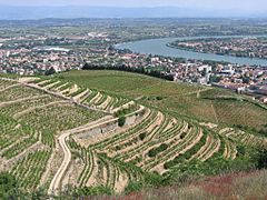
The valley of the Rhône river.
-
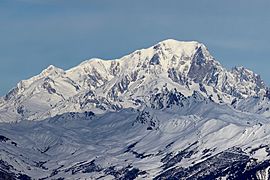
South side of the Mont Blanc.
-
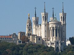
Fourvière Basilica (Lyon) viewed from the Saône river.
-
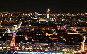
Overview on Lyon during Fête des Lumières.
-
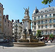
Fountain of the Three Orders, Grenoble


.jpg)


Related pages
See also
 In Spanish: Auvernia-Ródano-Alpes para niños
