
Nouvelle-Aquitaine facts for kids
Quick facts for kids
Aquitaine-Limousin-Poitou-Charentes
|
|
|---|---|
 |
|
| Country | |
| Departments | |
| Area | |
| • Total | 84,061 km2 (32,456 sq mi) |
| Population
(2012)
|
|
| • Total | 5,808,594 |
| • Density | 69.0997/km2 (178.9675/sq mi) |
| Time zone | UTC+1 (CET) |
| • Summer (DST) | UTC+2 (CEST) |
Aquitaine-Limousin-Poitou-Charentes is a large region in Southwestern France. It was formed in 2014 by joining three older regions: Aquitaine, Limousin, and Poitou-Charentes.
This new region is bigger than French Guiana. It is the largest region in all of France, covering an area similar to Austria. Its biggest city is Bordeaux. Bordeaux and its nearby towns form the 7th largest city area in France, with about 850,000 people. Since 2015, Bordeaux has been known as a "Métropole," which means it's a very important city center.
The region has many other important cities. Besides Bordeaux, some of the biggest are Bayonne, Limoges, Poitiers, Pau, and La Rochelle. Many people are moving to this region, especially to the coast. This makes it one of the most popular places to live in France.
The economy here is strong and varied. It relies on agriculture and making wine. Famous wines like Bordeaux and Cognac are known worldwide. Tourism is also very important, with many visitors enjoying the coast and countryside. Other key industries include aerospace, digital technology, and finance. For example, Niort is a major financial center for insurance companies. The coast is also a hub for companies that make gear for sliding sports.
Contents
Exploring the Geography of Aquitaine-Limousin-Poitou-Charentes
This region was created by combining three areas: Aquitaine, Limousin, and Poitou-Charentes. It covers 84,061 square kilometers. This makes it the largest region in mainland France and even larger than French Guiana. It is a big part of what is called "Midi de la France," or Southern France.
Aquitaine-Limousin-Poitou-Charentes shares borders with other French regions. To the northwest, it meets Pays de la Loire. To the north, it borders Centre-Val de Loire. To the east, it's next to Auvergne-Rhône-Alpes. In the southeast, it touches Occitanie. To the south, it shares a border with Spain.
The region has different types of land. It includes a large part of the Aquitaine Basin and a small part of the Paris Basin. It also has the Limousin plateau, which is part of the Massif Central mountains, and the western Pyrenees mountains. Five major rivers flow through the region towards the Atlantic Ocean. These include the Loire, Charente, Garonne, Dordogne, and Adour. These rivers help grow grapes for wine and support farming.

The region also has a long coastline along the Atlantic Ocean. This coast stretches from the Aiguillon Bay in the north to the Bidasoa river in the south. Along the coast are islands like Ré, Oléron, Aix, and Madame. There's also the big Arcachon Bay. This area is famous for oysters and mussels. It's also a popular place for tourism, with well-known resorts like Arcachon, Biarritz, and Royan.
From the Arvert peninsula to the coast of Labourd, the coastline is mostly straight. It has tall sand dunes, including the famous Dune du Pilat, which is the tallest sand dune in Europe. There are also large lakes like Lac d'Hourtin-Carcans and étang de Lacanau. Huge pine forests were planted here in the 1800s. The Landes forest is the biggest, covering almost a million hectares. It's the largest human-made forest in Western Europe. This forest replaced sandy, marshy land. Part of it is now the Landes de Gascogne Regional Natural Park.
Other important forests are found in the region. In the Basque Country, the Irati Forest covers over 17,000 hectares. The Double forest, with nearly 500 lakes, spans about 50,000 hectares. Near Poitiers, the Moulière forest is almost 6,800 hectares. Closer to Guéret, the Chabrières forest is 2,000 hectares.

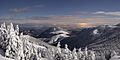
The very south of the region is mountainous, with the Pyrenees mountains. The western part has green hills, but further east, near Pau, the mountains are rockier. Many peaks here are over 2,000 meters high. The highest point in the region is Pic Palas (2,974 meters). Other impressive peaks include Pic du Midi d'Ossau (2,884 meters) and Pic de Ger (2,613 meters).
Many mountain streams, called "gaves," flow through this hilly area. Examples include the Gave de Pau and the Gave d'Ossau. The Ossau Valley is one of the three valleys in Béarn. It's known for its glacial lakes and amazing wildlife. This valley is part of the Pyrénées National Park.

Limousin, part of the Massif Central, also has hills and plateaus. It has green valleys and forests of oak and chestnut trees. The Limousin plateau is cut by rivers like the Vienne (which flows through Limoges), Isle, and Vézère. The highest point in the Limousin mountains is Mont Bessou (976 meters) in Corrèze. The northern part of Limousin has wooded hills and pastures.
The northern part of the region, called Haut-Poitou, has farms and vineyards. Rivers like the Vienne, Clain, and Gartempe flow through it. Further south, the Niortais area has open fields for growing grains. It also has wetlands like the Marais Poitevin, which is sometimes called "Green Venice." This area is famous for its natural beauty and is part of the parc naturel régional du Marais poitevin.

South of Poitou are the Charentes, which include Aunis, Angoumois, and Saintonge. Aunis has large marshes near La Rochelle and Rochefort. It also has islands like Ré and Aix, with pine forests and sandy beaches. The inland area is a rich plain for growing cereals. Surgères is known for its dairy farming and butter production.
Angoumois is a transition area between the coastal plains and the Limousin plateau. It has small hills and the Charente river flows through its main cities: Angoulême, Cognac, and Jarnac. This is a major wine region, famous for cognac, a type of brandy, and Pineau des Charentes. The western part of Charentes is Saintonge, centered around Saintes and Royan.
The Dordogne area is like the old province of Périgord. It's named after the Dordogne river, which flows through Bergerac. The area is very wooded, with 45% of its land covered by forests. The Green Périgord has oak and chestnut forests. The White Périgord is known for grain fields. The Black Périgord is famous for truffles. The Purple Périgord has vineyards that produce wines like Bergerac and Monbazillac.
The Gironde estuary connects Saintonge, Blayais, Médoc, and Guyenne. It's the largest wild estuary in Europe. It has marshes and hillsides where many famous Bordeaux wines are made. These wines are known all over the world and have brought fame to the region for centuries.
Further south is the large Landes plain, mostly covered by the Landes forest. It's also an important farming area, especially for corn. Dax is a famous spa town here.

The coastline here is very natural and wild, but it faces erosion. Some resorts have been built in the dunes, like Soulac-sur-Mer, Lacanau, Hourtin, Biscarrosse, Mimizan, and Capbreton. The bassin d'Arcachon is a large lagoon with towns like Arcachon and Lège-Cap-Ferret. Since 2014, it has been a marine natural park.
Eastern Guyenne includes the Lot-et-Garonne department. This area is rich in agriculture, watered by the Lot and Garonne rivers. It's famous for its prunes, named after its capital, Agen. Marmande is known for its tomatoes. The mild climate allows for growing tobacco, strawberries, and grapes for wines like Côtes du Marmandais. The region's true pride is Armagnac, a famous brandy exported worldwide. It also produces floc de Gascogne, a sweet wine.
The very south of the region has two distinct areas: the Basque Country (Northern Basque Country) and Béarn. The Basque Country, centered around Bayonne, Biarritz, and Saint-Jean-de-Luz, has a warm, humid climate. The Atlantic rains hit the Pyrenees mountains, making the area very green. The coast is a popular holiday spot. The inland area is more rural, with strong farming traditions and vineyards that produce Irouléguy wine. They also make traditional liqueurs like izarra.
Béarn, located in the heart of the Pyrenees, has its own Gascon traditions. It has rolling hills and valleys, like the Pau river valley, where Pau, Orthez, and Navarrenx are located. Agriculture and wine-making (Jurançon, Madiran) are important. There are also aerospace and petrochemical industries. Béarn is home to the main ski resorts in the area, such as Artouste and Gourette.
Climate and Weather in Aquitaine-Limousin-Poitou-Charentes
The Aquitaine-Limousin-Poitou-Charentes region mostly has an oceanic climate. This means it has moderate temperatures, not too hot or too cold. There are different types of oceanic climate here:
- Aquitaine oceanic climate: Covers most of the region, from Charentes to Landes.
- Paris oceanic climate: Found in Poitou.
- Limousin oceanic climate: In Limousin, with some influences from a continental climate.
- Basque microclimate: In the western part of the Pyrénées-Atlantiques and southern Landes, which is wetter.
The Pyrenean climate in the mountains is different. It's a type of mountain climate that changes with how high up you are.

In the north, the Paris oceanic climate brings moderate rain. Summers are warm, and winters are cool but not too cold. The Seuil du Poitou acts like a small climate barrier. Areas further south have the Aquitaine oceanic climate. Coastal areas get more rain throughout the year, except in summer when it can be dry. Summers are warm but cooled by sea breezes. Winters are mild, with little frost or snow. The region gets a lot of sunshine, about 2,000 to 2,200 hours a year. This is similar to some Mediterranean regions. Summer rain often comes as thunderstorms, which can be strong. Winters can have powerful storms, like Martin in 1999 and Klaus in 2009.
The climate in Angoumois and Limousin is wetter and cooler but still mild. Springs are warm, and summers are relatively warm. The amount of sunshine is about 1,850 hours per year. The climate in the Basque Country and southern Landes is known for warm summers and mild winters. It gets a lot of rain because Atlantic storms hit the Pyrenees mountains. This wet climate makes the region very green. Fog can happen but usually clears quickly.
The Pyrenean climate in Béarn is influenced by the ocean. It often experiences a "cap effect" when storms from the northwest hit the mountains. Valleys can get a lot of rain. In winter, there's heavy snow above 1,200 meters. The Pau valley has its own microclimate. It gets a lot of sunshine (about 1,900 hours a year) but also high rainfall (1,100 mm per year). Frost is rare in winter. Rain usually comes in short, regular bursts throughout the year.
Images for kids
-
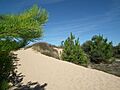
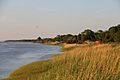
Sands dune in île d'Oléron (Charente-Maritime)
-
The vallée de Barétous (Pyrénées-Atlantiques)
-
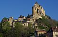
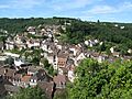
Medieval city of Castelnaud-la-Chapelle (Dordogne)
-
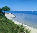
The main lake of Biscarrosse (Landes)
-
Old town of Aubusson (Creuse)
-
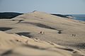
The Dune of Pilat is the tallest sand dune in Europe.
-
The Gironde estuary is the largest estuary in Western Europe.
-

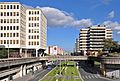
The ring road of Bordeaux supports a particularly heavy traffic.
-
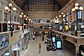
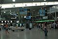
With 10 million passengers a year, the Bordeaux-Saint-Jean station is the largest station in the region.
-
The terminal of the Biarritz-Anglet-Bayonne Airport, which has the second greatest attendance in the region.
-
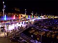
Royan harbour by night.
-
The business district of Mériadeck at Bordeaux, remained on a human scale.
-
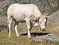
Blonde d'Aquitaine in the Pyrenees.
-
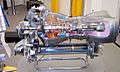
The Turbomeca Arriel turboshaft engine, manufactured in Bordes (Pyrénées-Atlantiques).
-
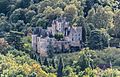
A view of the Castle of Fayrac in Castelnaud-la-Chapelle


.jpg)
.jpg)


See also
 In Spanish: Nueva Aquitania para niños
