
Angoulême facts for kids
Quick facts for kids
Angoulême
Engoulaeme (Poitevin–Saintongeais)
|
||
|---|---|---|
|
Prefecture and commune
|
||

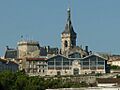
From top to bottom, left to right : The Cathedral of Angoulême; Panoramic view of the city ; Monument to Carnot; Théatre d' Angoulême.
|
||
|
||

Angoulême
Location in France

Angoulême
Location in Nouvelle-Aquitaine
|
||
| Country | France | |
| Region | Nouvelle-Aquitaine | |
| Department | Charente | |
| Arrondissement | Angoulême | |
| Canton | Angoulême-1, 2 and 3 | |
| Intercommunality | Grand Angoulême | |
| Area
1
|
21.85 km2 (8.44 sq mi) | |
| Population
(2021)
|
41,086 | |
| • Density | 1,880.4/km2 (4,870.1/sq mi) | |
| Demonym(s) | Angoumoisin (m) Angoumoisine (f) |
|
| Time zone | UTC+01:00 (CET) | |
| • Summer (DST) | UTC+02:00 (CEST) | |
| INSEE/Postal code |
16015 /16000
|
|
| Elevation | 27–130 m (89–427 ft) (avg. 100 m or 330 ft) |
|
| Website | angouleme.fr | |
| 1 French Land Register data, which excludes lakes, ponds, glaciers > 1 km2 (0.386 sq mi or 247 acres) and river estuaries. | ||
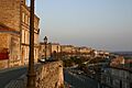
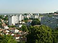
Angoulême is a cool city in southwestern France. It's the main city of the Charente area. People sometimes call it "the balcony of the southwest" because it sits high up, looking over a bend in the Charente River.
About 42,000 people live in the city itself. But if you count the surrounding areas, it's home to around 110,000 people!
Long ago, Angoulême was a strong, walled town. Its location was super important for travel, so it faced many attacks. Because of its busy past, the city, built on a rocky hill, has lots of old buildings and history that tourists love to see.
Today, Angoulême is a busy place with many industries. It's known for making paper, and also for its metal and electrical engineering factories. It's also a center for shopping and government. The city has a university and a lively cultural scene.
Angoulême is famous for its big events like the Angoulême International Comics Festival, the Angoulême Francophone Film Festival, and the Musiques Métisses Festival. These events make the city known worldwide! Plus, Angoulême has 40 animation and video game studios, creating half of France's animated shows. Even the movie The French Dispatch was filmed here.
Angoulême is also called "Ville de l'Image," which means "City of the Image." It has won awards for being a beautiful city with lots of flowers.
Contents
Geography: Where is Angoulême?
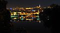
Angoulême is like an Acropolis city, built on a hill. It overlooks a loop of the Charente River. Other rivers like the Touvre and Anguienne join the Charente nearby.
Getting to Angoulême
Angoulême is easy to reach! It's located where two main roads cross:
- The N10 goes from Paris to Bayonne (north to south).
- The N14 connects Limoges to Saintes (east to west).
You can also get there by train. High-speed trains (TGV) connect Angoulême to Paris and Bordeaux. Local trains (TER) link it to Limoges and Saintes.
The Charente River was once used for moving goods, but now it's mostly for tourism. There's also the Angoulême-Cognac International Airport nearby.
 |
La Rochelle 120 km | Paris 435 km Poitiers 110 km Niort 110 km |
Montluçon 236 km Guéret 170 km Confolens 50 km |
|
| Cognac 40 km Saintes 70 km Royan 100 km |
Limoges 100 km | |||
| Bordeaux 110 km | Libourne 90 km Bergerac 110 km |
Périgueux 80 km |
Angoulême's Neighborhoods

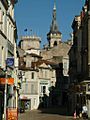
Old Angoulême is the historic part of the city, with narrow, winding streets and small squares. The city center is also on the high plateau. Famous writer Honoré de Balzac described it as a place of "grandeur and power." Here you'll find the City Hall and the Cathedral. Much of the city center was rebuilt in the 1800s.
Around the old city were five older neighborhoods: l'Houmeau, Saint-Cybard, Saint-Martin, Saint-Ausone, and la Bussatte.
- L'Houmeau was a busy trading area by the river, with a port built in 1280.
- Saint-Cybard grew around an old abbey and later became an industrial area with paper mills.
- Saint-Martin - Saint-Ausone were two former church areas outside the city walls.
- La Bussatte now has a shopping mall where a large open field used to be.
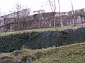
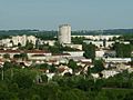
Today, Angoulême has fifteen neighborhoods, each with its own character. Some were built up with new housing after World War II, like Basseau and Sillac - La Grande-Garenne.
City Views

Nearby Towns and Villages
|
Saint-Yrieix-sur-Charente | Gond-Pontouvre | L'Isle-d'Espagnac | |
| Fleac | Soyaux | |||
| Saint-Michel | Vœuil-et-Giget | Puymoyen |
Rivers and Water
The old port of l'Houmeau is in a flood zone. Sometimes, during heavy floods, the main road there gets cut off.
Angoulême's Landscape

Angoulême is built on a high, flat area called a plateau. This plateau is made of limestone rock. The city sits on a rocky spur, about 100 meters (328 feet) high, overlooking the Charente River. The river valley itself is much lower, around 27 meters (88 feet) high.
The limestone plateau has natural caves, some of which people used long ago as grain storage.
The Ancient Walls
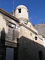
Since Roman times, walls have protected the Angoulême plateau. They were often destroyed and rebuilt. Today, these Ramparts are considered historical monuments![]() . Walking along them offers amazing views of the city and the river.
. Walking along them offers amazing views of the city and the river.
- The Ramparts of Angoulême
-
North Rampart
-
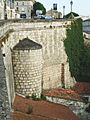
Near the covered market
-
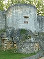
The Léchelle Tower
-
The Rampart du midi


Angoulême's Climate
Angoulême has an oceanic climate, meaning it's influenced by the ocean. It gets a moderate amount of rain throughout the year, with slightly less rain in the summer.
| Town | Sunshine (hours/yr) |
Rain (mm/yr) |
Snow (days/yr) |
Storm (days/yr) |
Fog (days/yr) |
|---|---|---|---|---|---|
| National average | 1,973 | 770 | 14 | 22 | 40 |
| Angoulême | 2,027 | 763 | 3 | 23 | 54 |
| Paris | 1,661 | 637 | 12 | 18 | 10 |
| Nice | 2,724 | 767 | 1 | 29 | 1 |
| Strasbourg | 1,693 | 665 | 29 | 29 | 56 |
| Brest | 1,605 | 1,211 | 7 | 12 | 75 |
| Climate data for Cognac | |||||||||||||
|---|---|---|---|---|---|---|---|---|---|---|---|---|---|
| Month | Jan | Feb | Mar | Apr | May | Jun | Jul | Aug | Sep | Oct | Nov | Dec | Year |
| Mean daily maximum °C (°F) | 9.4 (48.9) |
11.0 (51.8) |
14.4 (57.9) |
16.9 (62.4) |
20.8 (69.4) |
24.3 (75.7) |
26.8 (80.2) |
26.7 (80.1) |
23.5 (74.3) |
19.0 (66.2) |
13.0 (55.4) |
9.8 (49.6) |
18.0 (64.4) |
| Daily mean °C (°F) | 6.1 (43.0) |
6.9 (44.4) |
9.7 (49.5) |
11.9 (53.4) |
15.8 (60.4) |
19.0 (66.2) |
21.1 (70.0) |
20.9 (69.6) |
17.9 (64.2) |
14.4 (57.9) |
9.3 (48.7) |
6.6 (43.9) |
13.3 (55.9) |
| Mean daily minimum °C (°F) | 2.8 (37.0) |
2.8 (37.0) |
4.9 (40.8) |
6.9 (44.4) |
10.6 (51.1) |
13.6 (56.5) |
15.3 (59.5) |
15.0 (59.0) |
12.3 (54.1) |
9.9 (49.8) |
5.6 (42.1) |
3.3 (37.9) |
8.6 (47.5) |
| Average precipitation mm (inches) | 70.5 (2.78) |
51.4 (2.02) |
57.2 (2.25) |
69.6 (2.74) |
63.8 (2.51) |
50.6 (1.99) |
47.4 (1.87) |
45.3 (1.78) |
59.3 (2.33) |
79.5 (3.13) |
85.1 (3.35) |
83.1 (3.27) |
762.8 (30.03) |
| Average precipitation days (≥ 1 mm) | 11.6 | 9.2 | 10.1 | 11.2 | 10.5 | 7.4 | 6.9 | 6.5 | 8.0 | 11.2 | 11.5 | 11.6 | 115.7 |
| Mean monthly sunshine hours | 77.3 | 111.1 | 160.2 | 179.3 | 211.4 | 251.4 | 254.6 | 239.4 | 219.3 | 141.6 | 91.4 | 89.6 | 2,026.6 |
| Source: Meteorological data for Cognac - 59m altitude, from 1981 to 2010 January 2015 | |||||||||||||
History of Angoulême
The history of Angoulême before the Roman period isn't very clear. We know that a fortified settlement called Iculisma existed on the plateau.
Ancient Times

Angoulême wasn't a huge city during Roman times, but it grew and became important by the end of the Roman Empire. Its high, rocky location made it a great place for a fortress. The first city walls were built around the 3rd or 4th century.
The first bishop of Angoulême was Saint Ausone in the 3rd century. In 768, Pepin the Short made Angoulême part of the Frankish kingdom. In 2019, archaeologists found a 12,000-year-old stone with a horse carving near the train station!
The Middle Ages

In 508, Clovis, the King of the Franks, captured Angoulême from the Visigoths. Legend says he was wounded in the leg during the battle. You can even see a carving of a leg on an old tower, called "the leg of Clovis."

Clovis then built a new cathedral, Saint-Pierre, where the old one stood. In the 7th century, Saint Cybard lived in a cave near the city, which led to the creation of the Abbey of Saint-Cybard.
In 848, Vikings attacked Angoulême. Later, around 896 or 930, the city fought off another Viking attack. The local count, Guillaume I, was so brave that he earned the nickname Taillefer (meaning "iron-cutter"). This name was used by his family for a long time.
In 1204, King John of England signed a charter, officially creating the city of Angoulême. This gave the people more freedom and rights. The city celebrated its 800th anniversary in 2004!
During the Hundred Years War, Angoulême was controlled by the English for a while after the Treaty of Brétigny in 1360. But in 1373, French troops under Charles V took it back.
The County of Angoulême later belonged to Louis d'Orléans. His grandson, Jean d'Orléans, was the grandfather of King François I.
Modern Times
Angoulême became part of the French crown lands. In 1524, the explorer Giovanni da Verrazzano discovered a new land and named it New Angoulême in honor of King François I. This place later became New York!
John Calvin, a leader of the Protestant movement, hid in Angoulême in 1533 and wrote some of his famous book Institutes of the Christian Religion here.
The city also saw a peasant revolt in 1548 over a salt tax. During the French Wars of Religion, Angoulême was captured by Protestants in 1568.
World War II


In June 1940, German troops arrived in Angoulême during World War II. The city was in the occupied zone of France.
Sadly, on August 20, 1940, a group of Spanish refugees were sent from Angoulême to concentration camps. This was the first such transport in Europe.
On October 21, 1941, a young resistance fighter named Gontran Labrégère was shot by the occupiers. He was the first of many resistance members from Charente to lose their lives. In October 1942, 387 Jewish people were arrested and sent to Auschwitz; only eight returned.
The city suffered from Allied bombings in 1944, especially the railway station, which caused many civilian deaths and destroyed homes. Angoulême was finally liberated on the night of August 31 to September 1, 1944.
Today, a museum in Angoulême is dedicated to the Resistance and the deportations during the war.
After the War
After World War II, Angoulême grew a lot. New neighborhoods were built, and industries moved to larger areas outside the city center.
The city also invested in public works, like new roads, shopping centers, and public transport. This helped Angoulême become one of the biggest cities in the southwest of France.
Angoulême's Coat of Arms
.svg) |
The motto says: "FORTITUDO MEA CIVIUM FIDES" which means "My strength is in the loyalty of my citizens."
Blazon: |
The coat of arms of Angoulême has changed over time. It usually shows a castle with towers and a fleur-de-lis, which is a symbol of French royalty.
City Government

Angoulême is run by a mayor and a city council. The current mayor is Xavier Bonnefont.
Local Government Structure
Angoulême is divided into three cantons (smaller administrative areas):
- Angoulême-1
- Angoulême-2
- Angoulême-3
The city is also part of the Urban Community of Greater Angoulême, or Grand Angoulême. This group includes 16 nearby towns and helps manage services for the whole area.
City Development Projects
The Champ de Mars, a central square, now has an underground shopping area. New roads have also been built to improve traffic flow around the city. Many older housing areas are also being updated.
-
The historic centre with the city hall and the market
-
Pedestrian shopping area in the centre
-
The port of l'Houmeau and, in the background, the town centre of Angoulême.
-
District of Grande-Garenne
-
District of Grand-Font
-
Les Halles
-
The Bardines Hotel


Movies and TV Shows Filmed in Angoulême
Many movies and TV series have been filmed in Angoulême and the surrounding area, including:
- Blanche and Marie (1985)
- SOS 18 (TV series)
- Father and Mayor (TV series)
- Mammuth
- The French Dispatch (2018-2019) by Wes Anderson
Sister Cities
Angoulême has "sister city" relationships with other cities around the world. This means they share cultural exchanges and friendships.
 Bury, England, United Kingdom (1959)
 Hildesheim, Germany (1965)
 Vitoria Gasteiz, Spain (1967)
 Saguenay, Canada (1969)
 Gelendzhik, Russia (1977)
 Ségou, Mali (1984)
 Turda, Romania (1994)
 Hoffman Estates, United States (1996)
 Chaves, Portugal (2017)
Population of Angoulême
The people who live in Angoulême are called Angoumoisins (for boys/men) or Angoumoisines (for girls/women).
How Many People Live Here?
| Zone | Population | Area(km2) | Density (/km2) |
|---|---|---|---|
| Angoulême | 41,711 | 21.9 | 1,909 |
| Urban unit | 109,395 | 202.4 | 541 |
| Functional area | 179,758 | 1,512 | 119 |
| Charente | 351,778 | 5,956 | 59 |
Angoulême is the biggest city in the Charente area, with about 41,711 people living there in 2018. It's also the most crowded, with many people living per square kilometer.
The larger "urban unit" of Angoulême, which includes 18 towns, has over 109,000 people.
Population Changes Over Time
The number of people living in Angoulême has changed a lot over the years. It reached its highest population in 1962.
| Historical population | ||||||||||||||||||||||||||||||||||||||||||||||||||||||||||||||||||||||||||||||||||||||||||||||||||||||||||||||||
|---|---|---|---|---|---|---|---|---|---|---|---|---|---|---|---|---|---|---|---|---|---|---|---|---|---|---|---|---|---|---|---|---|---|---|---|---|---|---|---|---|---|---|---|---|---|---|---|---|---|---|---|---|---|---|---|---|---|---|---|---|---|---|---|---|---|---|---|---|---|---|---|---|---|---|---|---|---|---|---|---|---|---|---|---|---|---|---|---|---|---|---|---|---|---|---|---|---|---|---|---|---|---|---|---|---|---|---|---|---|---|---|---|
|
|
|||||||||||||||||||||||||||||||||||||||||||||||||||||||||||||||||||||||||||||||||||||||||||||||||||||||||||||||
| Source: EHESS and INSEE | ||||||||||||||||||||||||||||||||||||||||||||||||||||||||||||||||||||||||||||||||||||||||||||||||||||||||||||||||
Age Groups in Angoulême
Here's a look at the different age groups in Angoulême compared to the whole Charente area in 2017:
| Angoulême | Charente | |||
|---|---|---|---|---|
| Age Range | Men | Women | Men | Women |
| 0 to 14 Years | 16.7 | 14.4 | 16.7 | 14.8 |
| 15 to 29 Years | 25.2 | 21.7 | 15.7 | 13.8 |
| 30 to 44 Years | 19.3 | 16.7 | 17.1 | 16.3 |
| 45 to 59 Years | 17.4 | 18.7 | 21.1 | 20.8 |
| 60 to 74 Years | 13.9 | 16.1 | 19.6 | 19.8 |
| 75 to 89 Years | 6.6 | 10.3 | 8.9 | 12.0 |
| 90 Years+ | 0.8 | 2.1 | 0.9 | 2.4 |
Source: INSEE
Angoulême's Economy
Angoulême is a major center for making paper and for printing. This industry has been important here since the 1300s. The steady temperature and flow of the Touvre River, which joins the Charente, are perfect for paper making.

Many paper mills are located along the rivers. They produce everything from cardboard to fine paper. A well-known product made here is Rizla cigarette rolling paper. The Le Nil paper mill is now a Paper Museum.
The city's economy also gets a big boost from its yearly tourist events and festivals. Angoulême has a long history with cars and racing. The Circuit des Remparts is a famous car race held every year on the city streets. It's one of the last street races in France! Many famous drivers have raced here.
Other important industries include making machinery, electric motors, and wire. Angoulême is also the furthest inland port on the Charente River that boats can reach.
Transportation in Angoulême
Angoulême has a new high-speed rail line that connects it to Tours and Bordeaux. This line opened in 2017. You can take a TGV train from Paris to Angoulême in just over two hours. The Angoulême railway station also connects to Limoges and other regional places.
The Angoulême - Cognac International Airport is about 9.5 km (6 miles) northeast of the city. While it can handle large planes, there are currently no regular flights to or from this airport.
For getting around the city, Angoulême has a local bus system called STGA.
Culture and Heritage
Angoulême is known as a "City of Art and History."
The city has many old buildings and structures that are protected as historical monuments. The streets in the old town are often narrow and charming. The "old town" area is well-preserved and mostly for pedestrians. It has a lovely area with restaurants, art galleries, and shops.
Important Buildings and Places

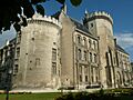
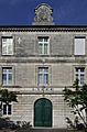
- The Town Hall (13th century)
 was designed in the 1800s but includes two old towers from a 13th-century castle. It has museums inside.
 - The Ramparts (4th century) are the old city walls that offer great views.
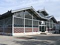
- The Market building (1886) is a beautiful building made of glass and iron.
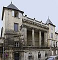
- The Municipal Theatre has a stunning front.
There are also many old houses, like the Maison Saint-Simon (16th century)![]() and the Hotel de Bardines (18th century)
and the Hotel de Bardines (18th century)![]() .
.
- Squares in Old Angoulême

- The Place du Minage has a fountain and benches, giving it a Mediterranean feel.
- The Place New-York was named in 1956 to remember that Giovanni da Verrazzano named the site of modern-day New York City "New Angoulême" in 1524.
- The Place Bouillaud and Place de l'Hotel de Ville are central squares near the City Hall.
- The Place Francis Louvel is a busy spot, named after a resistance fighter.
You can also see murs peints (painted walls) around the town. These are street art cartoons, showing Angoulême's connection to comics. There's even a statue of Hergé, who created The Adventures of Tintin.
In 2009, Angoulême received four flowers in the "cities and villages in bloom" competition, showing how beautiful it is.
-
Watchtower in the old Épernon wall
-
City Hall
-
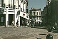
The Pedestrian shopping area in 1992
-
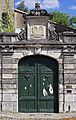
The 19th-century gate on the Hotel Montalembert
-
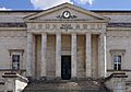
The Palace of Justice
-
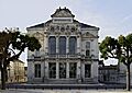
The Municipal Theatre
-
Entrance to the Guez de Balzac school


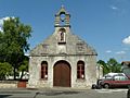
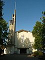
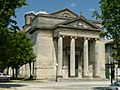
Religious Buildings
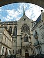
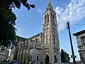
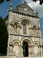
- Angoulême Cathedral (12th century) is dedicated to Saint Peter. It's a beautiful church in the Romanesque style. Its front has many sculptures showing the "Last Judgment."
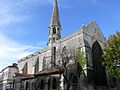
- The Church of Saint-André (12th century) has been rebuilt several times.
- A Lantern of the Dead in the cemetery of Saint-André (12th century) is actually a remnant of an old palace.
- The old Bishop's Palace (15th century) is now the Museum of Fine Arts.
- The Church of Saint-Martial (1849) and the Church of Saint Ausone are in the Neo-Romanesque style.
-
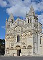
Angoulême Cathedral
-
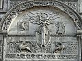
An Aureola on the Cathedral
-
Church of Obézine
-
Chapel Saint-Roch
-
Church of the Sacred Heart
-
Church of Saint-Jacques de l'Houmeau
-
Church Saint-Ausone
-
Chapel Saint-Cybard
-
Chapel of Cordeliers
-
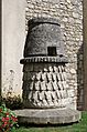
"Lantern of the dead" near the Church of Saint-André


Nature and Environment
The Charente River valley near Angoulême is a special Natura 2000 zone. It's home to many types of birds, especially wildfowl like swans, geese, and ducks. You can often see them on the river.
There are also hiking trails along the river, which are great for walks.
Museums in Angoulême
- Museum of Angoulême
- Museum of Paper
- Museum of Resistance and Deportation (about World War II)
- Museum of Cartoons (CIBDI)
Cartoons and Image City
Angoulême is often called the "City of the Image" or "Capital of Cartoons."
- The Regional School of Fine Arts in Angoulême (EESI) was the first in France to have a cartoon section.
- The International City of Cartoons and Images collects all comics published in France.
- The ENJMIN is a top school for video games and interactive media.
Other Cultural Spots
- The National Theatre
- The Espace Carat (a large center for exhibitions and concerts)
- La Nef (a concert hall)
- The Gabriel Faure conservatory (for music)
- The Alpha, a large public library.
Festivals in Angoulême
Angoulême is known for its many festivals throughout the year:
- Late January: Angoulême International Comics Festival (attracts huge crowds!)
- Late May: Musiques Métisses (Mixed Music Festival)
- Late August: Festival of Francophone Films
- September: Circuit des Remparts (Historic Car Race)
- Late October: Piano en Valois (Piano Festival)
- Late November: Gastronomades (Food Festival)
- Early November: The Grand Dance Festival
The city is also home to FITA (International Forum for Animation Technologies) in December, where professionals in animation and video games meet.
Angoulême was also a finish line for stages in the 2007 Tour de France bicycle race.
Schools and Services
Education in Angoulême
Angoulême has many schools for different age groups:
Colleges (Middle Schools)
- Marguerite de Valois College
- Anatole France College
- Pierre Bodet College
- Jules Michelet College
- Jules Verne College
- Michèle Pallet College
High Schools
- Lycée Guez-de-Balzac (general education)
- School of Image and Sound of Angoulême (LISA) (specialized in cinema, theater, audiovisual)
- Marguerite de Valois High School
- Charles de Coulomb High School (industrial education)
- Sillac High School (building trades)
- Jean Rostand School (fashion and services)
- Jean-Albert Grégoire School (transport and logistics)
- Oisellerie High School (agricultural college)
- Saint Paul High School (private school)
- Sainte-Marthe-Chavagnes School (private school)
University and Higher Education

The University Centre of Charente is part of the University of Poitiers. It offers studies in:
- Law and Social Sciences
- Sport Sciences
- Children's products
- University Institutes of Technology (IUT)
- Teacher training
Other important schools include:
- Gabriel Fauré Conservatory (music)
- EMCA (film animation school)
- EGC (management and business school)
- ENJMIN (National School for games and digital media)
- EESI (Higher European School of Imaging)
- CREADOC (documentary design)
Sports in Angoulême
Angoulême offers many sports activities:
- Rock climbing at places like Les Eaux-Claires.
- A sailing school at the lake of Saint-Yrieix.
- A women's handball team.
- The Angoulême CFC (ACFC) football (soccer) club.
- TTGF (Table Tennis Club).
- The SC Angoulême Rugby Club.
- The ACA (Angoulême Rowing Club).
Local Life
Places of Worship
Angoulême has several churches for Catholic worship, including:
- Saint-Pierre Cathedral
- Saint-André Church
- Church of Our Lady of Obézine
- Church of St. Ausone
- Saint-Jacques Church of l'Houmeau
- Church Saint-Martial
- Church of Saint-Bernadette
- Parish church of Saint-John the Baptist
- Church of Saint-Cybard
- Church of the Sacred Heart
Markets
- The Halles market, also known as the Covered Market, is famous for its large roof and 19th-century design. It's a historical monument.
- The Victor Hugo market.
- The Saint-Cybard market.
- The Basseau and Ma Campagne neighborhoods also have their own markets.
Military Presence
Angoulême is home to two regiments of the French armed forces:
 The 1st Marine Infantry Regiment
- The 515th régiment du train (a logistics regiment).
Famous People from Angoulême
Many notable people have connections to Angoulême:
- Isabella of Angoulême (1186–1246), who became Queen of England.
- John, Count of Angoulême (1399–1467), grandfather of King François I.
- Mellin de Saint-Gelais (c. 1491–1558), a Renaissance poet.
- Margaret of Valois-Angoulême (1492–1548), a French princess.
- André Thevet (1516–1592), an explorer and writer.
- Jean-Louis Guez de Balzac (1597–1654), a famous writer.
- Charles-Augustin de Coulomb (1736–1806), a military engineer and physicist.
- Paul Abadie (1812–1884), an architect who worked on the cathedral and city hall.
- François Mitterrand (1916–1996), who later became the President of France, went to school here.
- Prince Eudes, Duke of Angoulême (born 1968).

See also
 In Spanish: Angulema para niños
