
Périgueux facts for kids
Quick facts for kids
Périgueux
|
||
|---|---|---|
|
Prefecture and commune
|
||

Périgueux town hall
|
||
|
||

Périgueux
Location in France

Périgueux
Location in Nouvelle-Aquitaine
|
||
| Country | France | |
| Region | Nouvelle-Aquitaine | |
| Department | Dordogne | |
| Arrondissement | Périgueux | |
| Canton | Périgueux-1 Périgueux-2 |
|
| Intercommunality | Le Grand Périgueux | |
| Area
1
|
9.82 km2 (3.79 sq mi) | |
| Population
(2014)
|
30,069 | |
| • Density | 3,062.0/km2 (7,931/sq mi) | |
| Demonym(s) | Pétrocoriens | |
| Time zone | UTC+01:00 (CET) | |
| • Summer (DST) | UTC+02:00 (CEST) | |
| INSEE/Postal code |
24322 /24000
|
|
| Elevation | 75–189 m (246–620 ft) (avg. 106 m or 348 ft) |
|
| Website | perigueux.fr | |
| 1 French Land Register data, which excludes lakes, ponds, glaciers > 1 km2 (0.386 sq mi or 247 acres) and river estuaries. | ||
.svg)
Périgueux (Occitan: Perigüers) is a city in southwestern France. It is the main city and capital of the Dordogne area. It is also part of the Nouvelle-Aquitaine region.
Contents
Exploring Périgueux's Location
Périgueux is located in the middle of the Dordogne department. It is part of a tourist area called Périgord Blanc. The Isle River flows right through the city.
Périgueux is about 68 kilometers (42 miles) from Angoulême. It is also about 109 kilometers (68 miles) from Limoges, Agen, and Bordeaux. Cahors is about 100 kilometers (62 miles) away.
The city of Périgueux covers an area of 9.82 square kilometers (3.79 square miles). Its average height above sea level is 106 meters (348 feet). At the city hall, the height is 90 meters (295 feet).
Périgueux is surrounded by several other towns. These include Château-l'Évêque, Champcevinel, Trélissac, Boulazac, Notre-Dame-de-Sanilhac, Coulounieix-Chamiers, Marsac-sur-l'Isle, and Chancelade.
 |
Château-l'Évêque, Chancelade |
Champcevinel | Trélissac | |
| Marsac-sur-l'Isle | ||||
| Coulounieix-Chamiers | Notre-Dame-de-Sanilhac | Boulazac |
Périgueux's Climate
Périgueux has an oceanic climate. This means it has mild temperatures and rainfall throughout the year. Summers are usually warm.
Périgueux's Population
The people who live in Périgueux are called Pétrocoriens in French. Women are called Pétrocoriennes. Another common name for the residents is Périgourdins.
In 2014, the population of Périgueux was 30,069 people. This means there were about 3,062 people living per square kilometer (7,930 people per square mile).
How Périgueux's Population Has Changed
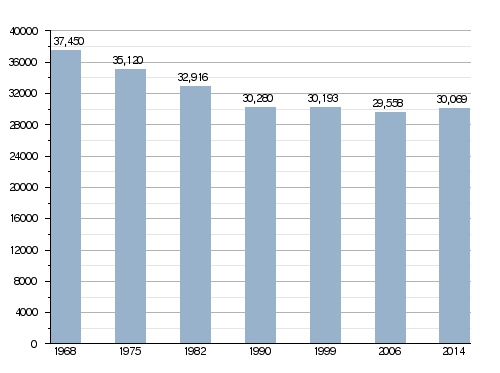
Périgueux is part of a larger urban area. This area includes 8 other towns. In 2013, this urban area had 66,895 people. It covered an area of 157.5 square kilometers (60.8 square miles). This urban area is also the center of an even larger metropolitan area. This bigger area has 55 towns and a population of 102,855 people (2013). It covers 108.7 square kilometers (42.0 square miles).
Périgueux's Government
Périgueux is the prefecture of the Dordogne department. This means it is the main administrative city for the area. It is also the capital of the Périgueux district.
The city is the administrative center for two cantons:
- Périgueux-1: This canton includes a part of Périgueux.
- Périgueux-2: This canton includes the rest of Périgueux.
Périgueux is also part of a group of towns called Le Grand Périgueux. This group works together on different projects.
Sister Cities of Périgueux
Périgueux has a sister city relationship with another city. This means they share cultural ties and friendly connections.
Gallery
-
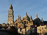
Saint Front cathedral.
-
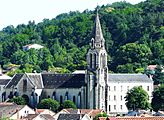
Saint-Georges church.
-
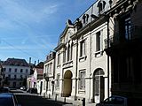
Périgueux Theater Palace.
-
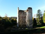
The Vésone tower.
.JPG)
.JPG)

.JPG)
Related pages
Images for kids
-
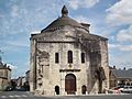
Saint-Étienne Church
-
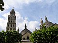
The bell tower of St Front's cathedral
-
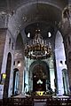
St Front's cathedral, inside


See also
 In Spanish: Périgueux para niños
