
Dordogne facts for kids
Quick facts for kids
Dordogne
|
|||
|---|---|---|---|
.JPG)
Prefecture building of the Dordogne department, in Périgueux
|
|||
|
|||

Location of Dordogne in France
|
|||
| Country | France | ||
| Region | Nouvelle-Aquitaine | ||
| Département | 4 March 1790 | ||
| Prefecture | Périgueux | ||
| Subprefectures | Bergerac, Nontron, Sarlat-la-Canéda | ||
| Area | |||
| • Total | 9,060 km2 (3,500 sq mi) | ||
| Population
(2014)
|
|||
| • Total | 416,350 | ||
| • Density | 45.955/km2 (119.02/sq mi) | ||
| Demonym(s) | Dordognots, Périgordins | ||
| Time zone | UTC+1 (CET) | ||
| • Summer (DST) | UTC+2 (CEST) | ||
| ISO 3166 code | FR-24 | ||
| Arrondissements | 4 | ||
| Cantons | 25 | ||
| Communes | 545 | ||
| Website | www.dordogne.fr | ||


Dordogne (Occitan: Dordonha) is a special area in the southwest of France. It is called a department. Its name comes from the Dordogne river, which flows right through it.
This department is part of the Nouvelle-Aquitaine region. It is located between the Loire river valley and the Pyrenees mountains. The main city, or prefecture, of Dordogne is Périgueux.
Contents
History of Dordogne: How It Was Formed
Dordogne was created a long time ago, on March 4, 1790. This happened during the French Revolution. It was made from parts of an older area called Périgord.
At first, Dordogne was divided into nine smaller areas called districts. These were Belvès, Bergerac, Excideuil, Montignac, Montpon, Nontron, Périgueux, Ribérac, and Sarlat.
For a while, the main city (capital) of the department changed between Bergerac, Périgueux, and Sarlat-la-Canéda. But later, everyone decided that Périgueux would be the only capital city.
Geography of Dordogne: Land and Rivers
Dordogne is part of the Nouvelle-Aquitaine region. It is the third largest department in Metropolitan France, which is the part of France in Europe. Only Gironde and Landes are bigger. Dordogne covers a large area of about 9,060 square kilometers (3,498 square miles).
Neighboring Departments: Who Borders Dordogne?
Dordogne shares its borders with seven other departments. These departments are in two different regions:
- Nouvelle-Aquitaine region:
- Occitanie region:
Rivers and Highest Point in Dordogne
The most important river in the department is the Dordogne river. It flows from east to west and gives the department its name. Other important rivers include the Isle and the Vézère. Both of these rivers flow into the Dordogne river.
The highest point in Dordogne is a hill called Forêt de Vieillecour. It is about 475 meters (1,558 feet) high. This spot is in the northwestern part of the Massif Central mountain range, close to the border with the Haute-Vienne department. The lowest point in Dordogne is in the Dordogne river valley, at about 16 meters (52 feet) above sea level.
Administration: How Dordogne is Governed
Dordogne is part of the Nouvelle-Aquitaine region. It is managed by a group called the Departmental Council of Dordogne. This council is located in Périgueux.
Administrative Divisions: How Dordogne is Organized
Dordogne is divided into smaller parts to help with its management. It has:
- 4 arrondissements (which are like large districts)
- 25 cantons (smaller administrative areas)
- 520 communes (which are like towns or municipalities)
Here are the four arrondissements of Dordogne:
| Arrondissement | Capital | Population (2014) |
Area (km²) |
Communes |
|---|---|---|---|---|
| Bergerac | Bergerac | 111,875 | 2,182.0 | 133 |
| Nontron | Nontron | 40,508 | 1,621.0 | 100 |
| Périgueux | Périgueux | 189,301 | 3,336.5 | 146 |
| Sarlat-la-Canéda | Sarlat-la-Canéda | 74,666 | 1,920.6 | 141 |
Demographics: People of Dordogne
The people who live in Dordogne are called Dordognais (for men) or Dordognaises (for women) in French. They are also known as Périgordins or Périgoudins.
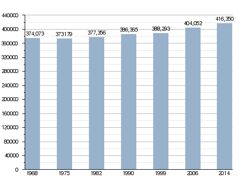
In 2014, Dordogne had a population of 416,350 people. This means there were about 46 people living in each square kilometer. The arrondissement of Périgueux is the largest, with 189,301 people. The other three, Bergerac, Nontron, and Sarlat-la-Canéda, had 111,875, 40,508, and 74,666 people, respectively.
How the population of Dordogne has changed over time
Major Cities in Dordogne
Here are the cities in Dordogne that have more than 5,000 people:
| City | Population (2014) |
Arrondissement |
|---|---|---|
| Périgueux | 30,069 | Périgueux |
| Bergerac | 27,764 | Bergerac |
| Boulazac Isle Manoire | 9,823 | Périgueux |
| Sarlat-la-Canéda | 9,127 | Sarlat-la-Canéda |
| Coulounieix-Chamiers | 8,089 | Périgueux |
| Trélissac | 6,732 | Périgueux |
| Terrasson-Lavilledieu | 6,186 | Sarlat-la-Canéda |
| Saint-Astier | 5,521 | Périgueux |
| Montpon-Ménestérol | 5,480 | Périgueux |
Explore Dordogne: A Photo Gallery
-
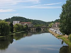
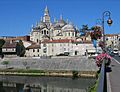
The river Isle flows through Périgueux.
-
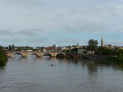
Bergerac city next to the Dordogne river.
-
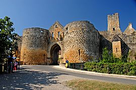
The Porte des Tours (Towers Gate) in Domme.
-
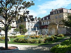
The 8 Mai 1945 square in Sarlat.

.JPG)

.jpg)

More About Dordogne
Images for kids
-
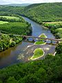
The Dordogne river near Castelnaud-la-Chapelle.
-
The Saint Front Cathedral in Périgueux.
-
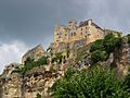
The impressive Château de Beynac.
-
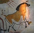
Ancient cave paintings of a horse from Lascaux.
-
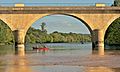
People enjoying canoeing on the Dordogne (river).
-
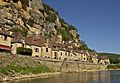
The village of La Roque-Gageac by the river.
-
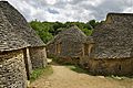
The unique stone huts at Cabanes du Breuil.


See also
 In Spanish: Dordoña (departamento) para niños
