
Pyrenees facts for kids
Quick facts for kids The Pyrenees Mountains |
|
|---|---|
| Spanish: Pirineos French: Pyrénées Catalan: Pirineus Aragonese: Pirineus Occitan: Pirenèus Basque: Pirinioak, Auñamendiak |
|

Central Pyrenees
|
|
| Highest point | |
| Peak | Aneto |
| Elevation | 3,404 m (11,168 ft) |
| Dimensions | |
| Length | 491 km (305 mi) |
| Naming | |
| Etymology | Named for Pyrene |
| Geography | |

Topographic map
|
|
| Countries | Spain, France and Andorra |
| Range coordinates | 42°40′N 1°00′E / 42.667°N 1.000°E |
| Geology | |
| Age of rock | Paleozoic and Mesozoic |
| Type of rock | granite, gneiss, limestone |
The Pyrenees are a huge group of mountains in southwest Europe. They form a natural border between France and Spain. These mountains separate the Iberian Peninsula from France. They stretch for about 430 km (267 mi). You can find them from the Atlantic Ocean (Bay of Biscay) all the way to the Mediterranean Sea (Cap de Creus).
Contents
Exploring the Pyrenees Mountains
The Pyrenees are a famous mountain range in Europe. They are like a giant natural wall. This wall divides Spain and France. A tiny country called Andorra is also found here.
Where are the Pyrenees located?
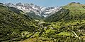
These mountains run from west to east. They start at the Bay of Biscay in the Atlantic. They end at the Cap de Creus on the Mediterranean coast. This long stretch means they cross many different landscapes.
How were the Pyrenees formed?
The Pyrenees were formed over millions of years. This happened when the Iberian Peninsula crashed into the rest of Europe. It was like two giant pieces of land pushing together. This powerful collision pushed up the land. It created the tall peaks we see today. The rocks here are mostly granite, gneiss, and limestone.
What are the highest peaks?
The tallest mountain in the Pyrenees is Aneto. It stands at 3,404 meters (11,168 feet) high. Aneto is located in Spain. Other high peaks include Monte Perdido and Pic du Midi d'Ossau. These mountains are often covered in snow. Some even have small glaciers.
Life in the Pyrenees
The Pyrenees are home to many different plants and animals. The weather changes a lot from the valleys to the high peaks. This means many types of life can thrive here.
Plants and trees of the Pyrenees
Lower down, you can find forests of oak and pine trees. Higher up, the trees become smaller and tougher. They can survive the cold and wind. There are also many beautiful wildflowers. These flowers bloom in the spring and summer.
Animals living in the Pyrenees
Many unique animals live in these mountains. You might spot chamois, which are like mountain goats. There are also marmots, which are furry rodents. Birds like the griffon vulture soar high above. Even brown bears live in some parts of the Pyrenees. They are very shy and hard to see.
Fun activities in the Pyrenees
The Pyrenees offer many exciting activities. People visit all year round. It's a great place for outdoor adventures.
Winter sports and skiing
In winter, the Pyrenees are popular for skiing and snowboarding. There are many ski resorts. Places like Cerler in Spain are well-known. People enjoy gliding down the snowy slopes.
Summer adventures and hiking
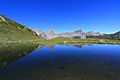
During summer, the mountains are perfect for hiking and mountain biking. You can explore beautiful trails. Many trails lead to stunning glacial lakes, called ibones. The Cirque de Gavarnie is a famous natural amphitheater. It has huge waterfalls.
Unique places to visit
The Pyrenees also have interesting human-made structures. The Pic du Midi de Bigorre has an observatory. You can see amazing views from there. The Odeillo solar furnace uses the sun's energy. It is one of the largest solar furnaces in the world.
Images for kids
-
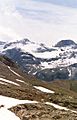
Monte Perdido, Aragon (Spain)
-
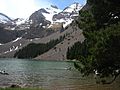
Ibón (glacial lake) Basa Mora, in Gistain valley, Aragon.
-
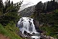
Aigualluts cascade in Benasque Valley, Aragon (Spain)
-
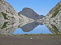
Ibón de Barrancs (glacial lake) in Posets-Maladeta Natural Park, Aragon (Spain)
-
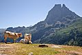
Some Blonde d'Aquitaine on summer pasture near the Pic du Midi d'Ossau
-
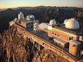
The observatory on the Pic du Midi de Bigorre.
-
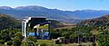
Odeillo solar furnace.
-
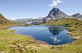
Pic du Midi d'Ossau reflected in the lac Gentau
-
Aiguilles d'Ansabère and Mesa de los Tres Reyes reflected in the lake of Ansabère
-
Gavarnie
-
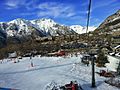
Ski Center, Cerler (Spain)


See also
 In Spanish: Pirineos para niños
