
Aneto facts for kids
Quick facts for kids Aneto |
|
|---|---|

North face of Aneto
|
|
| Highest point | |
| Elevation | 3,404 m (11,168 ft) |
| Prominence | 2,812 m (9,226 ft) Ranked 123rd |
| Listing | List of mountains in Aragon, Ultra |
| Geography | |

Aneto
Location in Pyrenees
|
|
| Location | Ribagorza, Aragon, Spain |
| Parent range | Pyrenees |
| Climbing | |
| First ascent | July 20, 1842 |
| Easiest route | Basic snow/ice climb |


Aneto is the highest mountain in the Pyrenees and in Aragon, a region in Spain. It is also Spain's third-highest mountain. Aneto reaches a height of 3,404 meters (11,168 feet). It is located in the Spanish province of Huesca, about 4 kilometers (2.5 miles) south of the France–Spain border. Aneto is part of the Maladeta mountain group.
Aneto is found in the Posets-Maladeta Natural Park. This park is in the town of Benasque, in the Huesca province of Aragon, Spain. The mountain is made of old rocks, mostly granite. Its northern side has the largest glacier in the Pyrenees. In 2005, this glacier covered about 79.6 hectares (197 acres). It is shrinking quickly because summers are getting warmer and winters have less snow. The glacier has lost more than half its size in the last 100 years. Scientists think it might disappear completely around 2050.
Contents
What's in a Name? The Story of Aneto
For a long time, this tall mountain didn't even have a proper name. Local shepherds and hunters sometimes called it Malheta or Malahita. The first person known to have seen it from a distance, Louis Ramond de Carbonnières, simply described it as "needles of ice" in 1787.
Eventually, the highest point of the Pyrenees got its name from a nearby village called Aneto. French explorers, who were the first to study the Pyrenees in detail, heard the local pronunciation. They often wrote down the name as "Netou" or other similar spellings. Even though the mountain is entirely in Spain, these French names were used for a long time. Later, a famous expert named Émile Belloc helped make "Aneto" the official name.
Aneto's Place in History
About 2 kilometers (1.2 miles) away from Aneto is the Maladeta peak. Even though Maladeta is not as tall as Aneto, it gave its name to the whole mountain group. For a while, climbers were more interested in Maladeta. This was because from the valley entrance, Maladeta looked like the highest peak. Aneto was hidden behind it.
In 1817, Friedrich von Parrot climbed Maladeta. That's when people realized that Aneto and its neighbors were actually taller. Before this, Monte Perdido was thought to be the highest mountain in the Pyrenees. After Aneto was discovered to be the highest, it started to get a reputation. Some serious accidents happened on the glaciers, which made people afraid. One famous climber, Luchon Barrau, died in an ice crack on Maladeta. This made locals believe the mountain was cursed.
Where is Aneto Located?

Aneto stands 3,404 meters (11,168 feet) above sea level in the middle of the Pyrenees mountains. It is entirely within Spain, just south of the main Pyrenees ridge and the border with France. The peak is in the northeast of the province of Huesca, above the town of Benasque.
Aneto is at the eastern end of the Malditos Massif. This massif is a 6-kilometer (3.7-mile) long ridge with peaks over 3,000 meters (9,842 feet) high. It connects Aneto with the Maladeta peak and other important summits.
Interestingly, the water from Aneto's northern slopes and glacier flows into a sinkhole called Forau de Aigualluts. From there, it travels underground to the east. It then reappears and flows into the Garonne river in France, eventually reaching the Atlantic Ocean. However, water from Aneto's western and southern sides flows into lakes. These waters eventually join the Ebro river and flow into the Mediterranean Sea. This means Aneto sits on the dividing line between rivers that flow to the Atlantic and those that flow to the Mediterranean.
Aneto's Glaciers
The Aneto-Maladeta mountain group was once home to the largest glaciers in the Pyrenees. These glaciers were hundreds of meters thick. Today, global warming has caused them to shrink a lot. Now, there are only eleven glaciers left, covering about 286 acres. No one is sure when the melting started, but it has sped up quickly. Experts believe that Aneto's glaciers might disappear by the middle of the 21st century. The glaciers here make up more than half of all the glaciers in Spain.
There are three main glaciers on Aneto's slopes:
- The Aneto glacier on the north side.
- The Barrancos glacier, next to Las Tempestades on the northeast side.
- The Maladetas glacier on the north side, under the Maladeta peak.
Other ice patches, like Cregüella, Alba, and Salenques, are shrinking fast. They are not really moving like true glaciers anymore. But they still hold ice from their past glacier state.
Climbing Aneto

Most climbers start their journey to Aneto from the Renclusa Refuge, a mountain hut at 2,140 meters (7,021 feet). From there, the path crosses a long part of the glacier north of the peak. To reach the very top, climbers must cross a short, rocky section called the Bridge of Mohammed. This is a narrow ridge with steep drops on both sides. At the summit, there is a large cross. The view from the top is amazing, showing the snowy Maladeta massif and the Alto Aragon region.
The usual climb is not very difficult, but it is long, often taking 12 hours. Many people climb Aneto each year, even those with little experience. This popularity helps the local economy. Many people staying at the Renclusa Refuge are there just to climb Aneto. Other nearby peaks, which some say are even better climbs, are much quieter.
First Ascent of Aneto
The first recorded climb of Aneto happened on July 20, 1842. A Russian officer named Platon de Tchihatcheff led the group. He was joined by guides Pierre Sanio de Luz, Bernard Arrazau, and Pierre Redonnet. Also with them were Albert de Franqueville, a botanist, and his guide, Jean Sors.
They started from Bagnères-de-Luchon in France. They crossed the Benasque Pass and spent the night at the La Renclusa shelter. The next day, they got a bit lost but eventually found shelter for the night. On the morning of July 20, they decided to cross the glacier to reach the summit. They bravely crossed the narrow "Bridge of Muhammad." Albert de Franqueville named it after a Muslim legend about a narrow path to Paradise. At the top, they built a small pile of stones and left a bottle with their names inside.
Tchihatcheff wanted to take a more direct way back across the glacier, but his companions said no. Four days later, he tried again with a different group. This time, they did cross the glacier directly, even though it had many cracks. Aneto then became a very popular climb.
First Winter Ascent
The first time Aneto was climbed in winter was on March 1, 1878. Roger de Monts, B. Courrèges, and B. and V. Paget were the brave climbers.
First Sea to Summit Ascent
In 2020, Louis-Philippe Loncke achieved a unique feat. He started from the Atlantic Ocean and climbed Aneto without any extra supplies or support. He reached the summit on August 19, 2020, which was day 25 of his journey across the Pyrenees.
Plants and Nature

The special nature of the Aneto area has led people to focus on tourism instead of farming. Because of this, the plants and forests in the area are very well preserved.
High Alpine Plants
The highest parts of the mountain, reaching 3,404 meters (11,168 feet), are tough for plants to grow. The weather is harsh, with strong sunlight, very cold temperatures, and snow for most of the year. Plants here need to be super tough to survive.
There are no tall trees in this area. Instead, you can find over 100 types of plants. These include lichens, mosses, and tiny algae. Some special plants like the Androsace Vandelli and the Silene acaulis grow here. About 20% of these plant species are found only in the Pyrenees.
Aneto in the Sky
There's an aviation intersection called ANETO very close to the mountain. It's right on the border between France and Spain. For pilots flying over the Pyrenees, this spot marks where the Bordeaux and Barcelona airspaces meet.
See Also
 In Spanish: Pico Aneto para niños
- List of Pyrenean three-thousanders
Images for kids
-
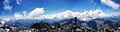
Aneto Peak (3404m) summit panorama, looking South West, Pyrenees range
