
Maladeta facts for kids
Quick facts for kids Maladeta |
|
|---|---|

Maladeta
|
|
| Highest point | |
| Elevation | 3,312 m (10,866 ft) |
| Listing | List of mountains in Aragon |
| Naming | |
| English translation | from "damned mountains" |
| Language of name | Spanish |
| Geography | |

Maladeta
Location in Pyrenees
|
|
| Location | Ribagorza, Aragon, Spain |
| Parent range | Pyrenees |
| Climbing | |
| First ascent | 28 September 1817 |
Maladeta is a tall mountain in the Pyrenees mountain range. It stands at 3,312 meters (about 10,866 feet) high. It's very close to Aneto, which is the highest peak in the Pyrenees.
You can find Maladeta in the Natural Park of Posets-Maladeta. This park is near the town of Benasque in Aragon, Spain. On its northern side, there's a large glacier called the Maladeta Glacier. This glacier covers about 37 hectares (about 91 acres). It is split into two parts: the Western Maladeta and the Eastern Maladeta.
For a long time, people thought Maladeta was the highest peak in the area. Because of this, many climbers tried to reach its top first. The first successful climb was on September 28, 1817. It was done by Johann Jacob Friedrich Wilhelm Parrot and his guide, Pierre Barrau.
Contents
What Does "Maladeta" Mean?
The name "Maladeta" comes from the Spanish words montes malditos. This means "Damned Mountains." Some people believe the local name for the mountain group was Mala hita. This could mean "bad rocks" or "bad upper regions."
When French travelers came to the area, they translated the name into French as "Maladette." They thought it sounded like the Italian word Maladetta, which also means "damned." Over time, the name Maladeta became popular. It now refers to the entire group of mountains.
A Brief History of Maladeta's Exploration

Even though Maladeta isn't the tallest mountain in its group, it was named for the whole area, also called Montes Malditos. It was very popular with early climbers, especially in the 1800s. This is because its summit looks like the highest point when you enter the valley from Benasque or France.
From these views, a ridge called the Cresta Portillones hides the true height of its neighbor, Aneto. Aneto is actually taller and has bigger glaciers. Some of the first people to try climbing Maladeta were Ramond in 1787, Ferrieres in 1801, and Louis Cordier in 1802.
It wasn't until 1817 that the German scientist Johann Jacob Friedrich Wilhelm Parrot and his guide, Pierre Barrau, reached the summit. After their climb on September 28, 1817, they discovered that Aneto was actually higher.
Sadly, Pierre Barrau, who was a top expert in the area, died in a deep crack in the Maladeta glacier in 1824. Because of this accident, local people became very scared to go onto the ice. They thought the glacier was unlucky. Many years later, in 1931, the glacier moved and revealed his body.
In the early 1900s, a mountain hut called Refugio de la Renclusa opened. It can hold 93 people and is a common starting point for climbing Aneto. It is located 2,140 meters (about 7,021 feet) above sea level. You can reach it by following a path from the La Besurta recreational area.
Because of its amazing wildlife and important glaciers, Maladeta and the entire mountain range were made a natural park in 1994. It is also part of the Pyrenean Glaciers Natural Monument.
Where is Maladeta Located?

Maladeta rises 3,308 meters (about 10,853 feet) above sea level. It is right in the middle of the Pyrenees, near the border between France and Spain. The summit is in the northeast part of the Province of Huesca. It sits in the center of the Montes Malditos mountain group.
To its east, Maladeta is connected to Aneto by a 3,000-meter (about 9,843 feet) line of peaks. This line includes Pico Maldito, Pico del Medio, and Pico de Coronas. These peaks, along with the Cresta del Portillones, make the mountains look like a solid wall.
The snow melting from Maladeta's slopes feeds the beginnings of the Ésera and Ballibierna rivers. Both of these rivers flow on the southern side of the mountain.
The Maladeta range is surrounded by valleys. A high hill, over 2,500 meters (about 8,202 feet) tall, called Perdiguero, separates the Arán valley from France. The Spanish side of the mountains is wider and less easy to reach. It is separated from the lower hills by deep gorges and ravines from the Posets and Maladeta mountain ranges. The Cerler alpine ski resort is located two valleys further south.
How to Climb Maladeta

The usual way to climb Maladeta is the same as for Aneto for part of the journey. You follow the path up to the upper Portillón. From there, you continue straight to the bottom of the Maladeta crest. You can reach this crest by a steep path to a very clear rock.
Climbing this route can be difficult. A deep crack, called a bergschrund, often opens up in the glacier after winter. Because of these challenges, climbing Maladeta is only suggested for climbers who have a lot of experience.
The mountain hut La Renclusa is often the starting point for climbs. It is located in the foothills at about 2,500 meters (about 8,202 feet) high.
See also
- List of Pyrenean three-thousanders
- In Spanish: Maladeta para niños
Images for kids
-
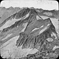
Maladeta
-
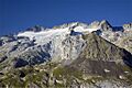
The peaks of Coronas, Medio, and Maldito, with Maladeta on the far right, seen from Aneto.
-
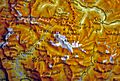
Map of the Maladeta range, showing surrounding valleys and mountains.
-
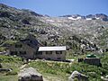
The La Renclusa mountain hut.
