
Aragon facts for kids
Aragon is a special region in northeastern Spain. It's called an autonomous community, which means it has its own government and rules, like a mini-country within Spain.
Aragon is named after the Aragón River, which flows into the Ebro River. This region covers the same area as the old medieval Kingdom of Aragon.
Aragon has three main areas, called provinces, from north to south: Huesca, Zaragoza, and Teruel. The main city and capital is Zaragoza.
Quick facts for kids Aragon (Aragón) |
|||
| Autonomous community (Comunidad autónoma) | |||
|
|||
| Official name: Comunidad Autónoma de Aragón | |||
| Country | |||
|---|---|---|---|
| Region | Iberian Peninsula | ||
| Capital and largest city | Zaragoza | ||
| - elevation | 7 m (23 ft) | ||
| - coordinates | 41°39′N 0°39′W / 41.650°N 0.650°W | ||
| Highest point | Aneto | ||
| - location | Ribagorza, Pyrenees, |
||
| - elevation | 3,404 m (11,168 ft) | ||
| - coordinates | 42°37′56″N 0°39′28″W / 42.63222°N 0.65778°W | ||
| Lowest point | Ebro | ||
| - location | Zaragoza, Ebro Valley, |
||
| - elevation | 65 m (213 ft) | ||
| - coordinates | 41°39′0″N 0°53′0″W / 41.65000°N 0.88333°W | ||
| Area | 47,719 km² (18,424 sq mi) | ||
| Population | 1,347,150 (2013) | ||
| Density | 28 /km² (73 /sq mi) | ||
| Statute of Autonomy | 10 August 1982 last revision April 2007 |
||
| President | Luisa Fernanda Rudi (Partido Popular) | ||
| Timezone | CET (UTC+1) | ||
| - summer (DST) | CEST (UTC+2) | ||
| ISO 3166-2 code | ES-AR | ||
| Demonym | Aragonese Spanish: Aragonés (sa) |
||
| Anthem | Himno de Aragón | ||
| Currency | Euro (€) | ||
| Date format | dd-mm-yyyy | ||
| Drive | right-side | ||


Contents
Geography of Aragon
Aragon is one of Spain's 17 autonomous communities. It covers a large area of about 47,719 square kilometers (18,424 square miles). This makes it the fourth largest autonomous community in Spain.
Aragon shares borders with France to the north. Within Spain, it borders Catalonia to the east and the Valencian Community and Castile-La Mancha to the south. To the west, it borders Castile and León, La Rioja, and Navarre.
Mountains and Valleys
Most of Aragon is quite high up, ranging from 201 to 3,404 meters (659 to 11,168 feet) above sea level. The highest point is Aneto peak, which is 3,404 meters (11,168 feet) high. It's the tallest mountain in the Pyrenees mountain range.
The lowest point in Aragon is along the Ebro River, near Zaragoza. It's only 65 meters (213 feet) above sea level.
Aragon has three main geographical areas:
- The Aragonese Pyrenees are in the north. This mountain range separates Spain from France. Some of the highest mountains here include Aneto (3,404 m), Posets Peak (3,375 m), and Monte Perdido (3,355 m). Rivers like the Veral, Aragon Subordán, and Gállego flow through the valleys here. The beautiful Ordesa y Monte Perdido National Park is also in this area.
- The Ebro Valley is further south. This area is watered by the Ebro River. It's a very rich and fertile area for farming. You can see huge fields of wheat, barley, and other fruit and vegetable crops. Many old settlements, castles, and Roman ruins are found here.
- The Sistema Ibérico is a system of mountain ranges south of Zaragoza. These mountains separate the Ebro Valley from the central plains of Spain. The highest mountain in this range is Moncayo, which is 2,314 meters (7,592 feet) high.
Rivers of Aragon
Most rivers in Aragon flow into the Ebro River, which is Spain's largest river by volume. The Ebro River actually divides Aragon into two parts.
Important rivers that join the Ebro from the Pyrenees (on its left side) include the Aragón River, the Gállego, and the Cinca. Rivers that join the Ebro from the right side include the Jalón, Huerva, and Guadalupe.
Near the border with Catalonia, there's a large Reservoir called Mequinenza. It's about 110 kilometers (68 miles) long and is often called the Sea of Aragon.
Aragon's Climate

Aragon has different types of weather:
- Continental Mediterranean: This is found in the Ebro Valley. It has hot summers and cold winters, with big changes in temperature between day and night. It doesn't get much rain.
- Alpine-mountain climate: This is in the mountains. Summers are short, and winters are very cold. The exact temperature depends on how high up you are and which way the slopes face.
- Continental: This is in the Calatayud-Daroca-Teruel region. Mountains block humid winds, so it doesn't rain much (600-900 mm or 24-35 inches per year). Summers are hot, and winters are very cold.
In the middle of Aragon, where it's only about 200 meters (656 feet) above sea level, the average yearly temperature is around 14°C (57°F). In the mountains, between 600 and 1,000 meters (1,969 and 3,281 feet), temperatures are a bit cooler, around 11 to 12°C (52 to 54°F).
How Aragon is Divided
Aragon is made up of three provinces. They are named after their main cities: Huesca, Teruel, and Zaragoza. Each province is then divided into smaller areas called comarcas. These comarcas are further divided into municipalities.
.jpg)
| Province | Capital | Population | Area (km2) |
Municipalities |
|---|---|---|---|---|
| Huesca | Huesca | 226,329 | 15,626 | 202 |
| Teruel | Teruel | 142,183 | 14,809 | 236 |
| Zaragoza | Zaragoza | 978,638 | 17,274 | 292 |
People of Aragon
In 2013, Aragon had a population of 1,347,150 people. This means it has one of the lowest population densities in Spain, with about 28 people per square kilometer. Most people live in the Ebro River valley, especially around Zaragoza. More people also live in the foothills of the Pyrenees.
Areas with fewer people tend to be higher up in the Pyrenean mountains and in most of the southern province of Teruel.
The province of Zaragoza has the most people, with 978,638 inhabitants. This is about 72.6% of Aragon's total population.
The largest city is the capital, Zaragoza, with 620,419 people. The other provincial capitals, Huesca and Teruel, have 47,923 and 31,506 inhabitants, respectively.
Main Cities
Here are the 10 most important cities in Aragon:

| City | Population (2011) |
Province |
|---|---|---|
| Zaragoza | 620,419 | Zaragoza |
| Huesca | 47,923 | Huesca |
| Teruel | 31,506 | Teruel |
| Calatayud | 18,531 | Zaragoza |
| Ejea de los Caballeros | 16,183 | Zaragoza |
| Barbastro | 15,457 | Huesca |
| Alcañiz | 13,708 | Teruel |
| Fraga | 13,035 | Huesca |
| Jaca | 12,322 | Huesca |
Languages Spoken

Spanish is the main language spoken in most of Aragon. It is the only official language, and almost everyone in the region understands and speaks it.
However, the Aragonese language is still spoken in some local areas. You can hear it in the mountainous northern parts of the Pyrenees.
In the eastern parts of Aragon, near the border with Catalonia, people also speak different types of the Catalan language.
Images for kids
-
Hermitage of la Virgen de la Peña in Aniés, La Sotonera, province of Huesca
-
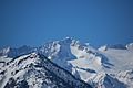
Aneto peak is the highest point of all Pyrenees. It is located in the Posets–Maladeta Natural Park.
-
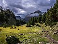
La Besurta trail in the Benasque Pyrenean Valley
-
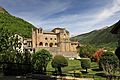
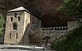
Abbey of San Pedro de Siresa, monastic, political and cultural center of the ancient County of Aragon, where Alfonso I was educated. It is located in the Hecho Pyrenean Valley.
-
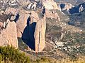
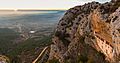
Mallos de Riglos conglomerate rock formations, in Las Peñas de Riglos
-
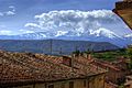
Moncayo Massif seen from Tarazona. Moncayo, with its height of 2314.3 m, is the maximum summit of the Sistema Ibérico mountainous chain.
-
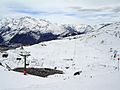
Formigal Ski Resort near Formigal town, Sallent de Gállego
-
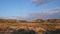
Monegros site, of arid climate and extreme temperatures
-
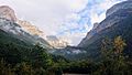
Inside Ordesa Valley, of the Ordesa y Monte Perdido National Park
-

Aerial view of Aiguabarreig in Mequinenza
-
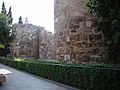
The remains of the Roman walls of Zaragoza
-
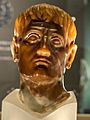
Bust of Augustus found in Tarazona
-
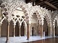
The Aljafería, of the 11th century, was residence of the Banu Hud kings of the Taifa of Saraqusta.
-
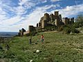
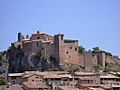
Castle of Loarre was built and expanded to serve as a frontier advance towards Muslim territories. It is one of the most important intact Romanesque castles in Europe.
-
Royal Monastery of San Juan de la Peña. In its Royal Pantheon a good number of kings of Aragon and some kings of Navarre are buried.
-
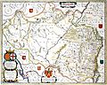
Aragonia Regnum, map of the Blaeu based on that of João Baptista Lavanha published circa 1640
-
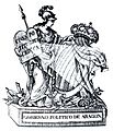
1820 Emblem of the Political Government of Aragon under the Liberal Triennium (1820)
-
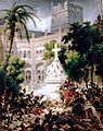
French troops storming the Abbey of Santa Engracia, February 1809, painted by Lejeune
-
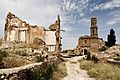
Belchite town, destroyed during the Battle of Belchite, became a symbol of the Spanish Civil War.
-
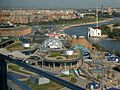
General view of the Expo 2008 from the Torre del Agua
-
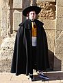
The Fragatina costume historical of Fraga
-
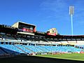
La Romareda, home ground of Real Zaragoza
-
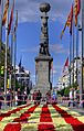
La Plaza de Aragón square in Zaragoza, on Saint George's Day, with a flag of Aragon of flowers
-
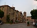
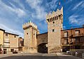
Aínsa, Aínsa-Sobrarbe
-
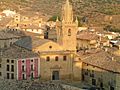
Collegiate Church of Santa María la Mayor in Alquézar
-
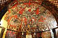
Gothic murals of the Crypt of Santa María del Perdón of the Church of San Esteban in Sos del Rey Católico
-
Puerta Baja gate in Daroca
-
Church of Santa María in Uncastillo
-
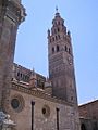
Tarazona
-
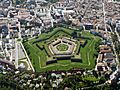
Citadel of Jaca in Jaca
-
Aerial view of Mequinenza


.jpg)


See also
 In Spanish: Aragón para niños
