
Moncayo Range facts for kids
Quick facts for kids Moncayo |
|
|---|---|

View of Cueva de Ágreda town with the massive three summits of the Moncayo in the background
|
|
| Highest point | |
| Elevation | 2,314 m (7,592 ft) |
| Listing | Mountains of Aragon |
| Geography | |

Moncayo
Location in Spain
|
|
| Location | Tarazona y el Moncayo, Campo de borja, Aranda (Aragon) Province of Soria (Castile and León) |
| Parent range | Sistema Ibérico |
| Geology | |
| Mountain type | Slate |
| Climbing | |
| First ascent | Unknown |
| Easiest route | From the Santuario de la Virgen del Moncayo, from Cueva de Ágreda or from Beratón |
The Moncayo is a mountain range in Spain. It is about 15 kilometers (9 miles) long and 7 kilometers (4 miles) wide. The highest peak is called San Miguel, standing tall at 2,314 meters (7,592 feet). This makes it the tallest point in the Sistema Ibérico, a long mountain system stretching 500 kilometers (310 miles) across Spain.
Moncayo sits between two Spanish regions: Aragon (in Zaragoza province) and Castile and León (in Soria province). The highest parts of the mountain are usually covered in snow from October to May each year.
About the Moncayo Mountains
The Moncayo mountain group has three main peaks that are very close to each other. Besides San Miguel, there is Cerro San Juan (2,283 meters or 7,490 feet) and Peña Lobera (2,226 meters or 7,303 feet).
This mountain was known as Mons Caius in ancient times. The Roman writer Marcus Valerius Martialis mentioned it in his writings.
The closest large town to Moncayo is Tarazona. It is about 10 kilometers (6 miles) north of the mountain. Tarazona has many old and interesting buildings to explore. There are also smaller villages located even closer to the mountain range.
The Sierra de Nava Alta and Sierra del Bollón are smaller mountain areas that extend from the eastern side of the Moncayo.
Hiking and Exploring Moncayo
Moncayo is a very popular place for hiking in Spain. It is easy to reach the mountain using public transport. During the summer, buses run almost every hour. In winter, there are fewer buses.
A special road for hikers starts from the village of San Martín de la Virgen de Moncayo. This road leads to the village of Agramonte. The lower parts of the mountain are covered with forests. You can find oak trees and spiky shrubs growing there.
On the northern side of the mountain, there is a wide path that winds its way upwards. In the northeast part of the mountain, there is a stone mountain hut. This hut can be used as a safe place in emergencies. It is located near a car park, just north of the Lobera peak.
A small river flows on the northwest side of the mountain. You can climb to the highest peak, San Miguel, from Agramonte. Another way to go up is from the eastern side of the mountain range, passing by Lobera peak. The climb usually takes about three hours. There are some parts with loose stones, but you can avoid them by staying on the marked paths. On a clear day, from the top of San Miguel, you might even see the Pyrenees mountains far away!
Images for kids
-
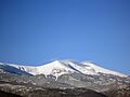
View of the Pico de San Miguel.
-
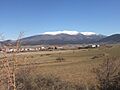
Moncayo seen from Ólvega.
-
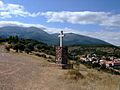
Cross at San Martín de la Virgen de Moncayo.


See also
 In Spanish: Sierra del Moncayo para niños
- Tarazona
- Sistema Ibérico
- List of mountains in Aragon
