Garonne facts for kids
Quick facts for kids Garonne |
|
|---|---|

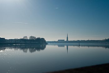
The Garonne at Bordeaux
|
|

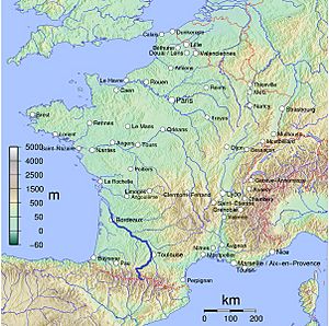
Map of the Garonne
|
|
| Countries | France and Spain |
| Physical characteristics | |
| Main source | Pyrenees 2,600 m (8,500 ft) 42°36′26″N 0°57′56″E / 42.607295°N 0.965424°E |
| River mouth | Gironde estuary, Atlantic Ocean 45°2′29″N 0°36′24″W / 45.04139°N 0.60667°W |
| Length | 529 km (329 mi) |
| Basin features | |
| Progression | Gironde estuary→ Atlantic Ocean |
| Basin size | 56,000 km2 (22,000 sq mi), or including Dordogne: 84,811 km2 (32,746 sq mi) |
The Garonne is a major river in southwest France and northern Spain. It starts high in the Pyrenees mountains in Spain and flows all the way to the Gironde estuary near the French city of Bordeaux. The river is about 529 km (329 mi) long. A small part of it, 47 km (29 mi), is in Spain. If you include the Gironde estuary, which is like a wide river mouth, the total length reaches 602 km (374 mi).
The area drained by the Garonne is huge, covering about 56,000 km2 (22,000 sq mi). This area grows to 84,811 km2 (32,746 sq mi) if you add the Dordogne River. The Dordogne joins the Garonne at a place called Bec d'Ambès, and together they form the Gironde estuary.
Long ago, in 732, a big battle called the Battle of the River Garonne happened near the river, close to where Bordeaux is today.
Contents
What's in a Name? The Garonne's Meaning
The name Garonne comes from an old Latin name, Garumna. This name came from an even older local language called Aquitanian. It means "stony river," with "kar" meaning "stone" and "-ona" meaning "river."
Where Does the Garonne River Flow?
Finding the Garonne's Source
The Garonne River starts in the Aran Valley in the Spanish Pyrenees mountains. People have suggested three different places as the river's true beginning.
One idea is the Uelh deth Garona, which is 1,862 metres (6,109 ft) above sea level. A small stream, called the Beret-Garona, flows from here for about 2.5 kilometres (1.6 mi).
Another idea is the Ratera-Saboredo cirque. A cirque is a bowl-shaped valley. The highest lake in this cirque, at 2,600 metres (8,500 ft) above sea level, is the start of the Ruda-Garona river. This river flows for 16 kilometres (9.9 mi) until it meets the Beret-Garona stream. Many experts believe this is the real source.
The third idea is that the river starts on the slopes of Pic Aneto, at 2,300 metres (7,500 ft) high. Water from this area disappears into a sinkhole called the Forau de Aigualluts. It then flows underground through limestone rock. In 1931, a caver named Norbert Casteret proved this by pouring a special dye into the sinkhole. A few hours later, the colored water appeared 4 kilometres (2.5 mi) away at Uelhs deth Joèu ("Jove's eyes").
Even though there are different ideas, many groups like the United States Geological Survey say that a river's source is the farthest point from its mouth where water flows. Based on this, the Ratera-Saboredo cirque is often considered the true source of the Garonne.
The Garonne's Journey to the Ocean

From the Aran Valley, the Garonne flows north into France. It passes through important cities like Toulouse and Agen before reaching Bordeaux. After Bordeaux, the Garonne meets the Dordogne River at the Bec d'Ambès. Together, they form the wide Gironde estuary. This estuary then flows for about 100 kilometres (62 mi) before emptying into the Atlantic Ocean (Bay of Biscay).
Along its journey, the Garonne is joined by several other big rivers. These include the Ariège, the Tarn, and the Lot. Other smaller rivers like the Save and the Gers also flow into the Garonne.
The Garonne's Tidal Bore
The Garonne is special because it has something called a tidal bore. This is a strong wave that travels upstream against the river's current, caused by the incoming tide. Surfers and jet skiers can sometimes ride this wave far up the river, even 120 kilometres (75 mi) from the Atlantic Ocean! The bore's strength can change depending on the river's shape.
Saving the European Sea Sturgeon

The European sea sturgeon (Acipenser sturio) is a very rare fish. It's listed as a Critically Endangered species by the IUCN ![]() . These amazing fish can grow up to 6 m (20 ft) long and weigh as much as 400 kg (880 lb). They can also live for 100 years!
. These amazing fish can grow up to 6 m (20 ft) long and weigh as much as 400 kg (880 lb). They can also live for 100 years!
They used to live along most coasts of Europe. But now, they are so rare that the only place they still breed naturally is in the Garonne river basin in France. People are working hard to save this fish from extinction. They are trying to reintroduce sturgeon raised in special fish farms back into the river. The first releases happened in 1995.
Cities and Towns Along the Garonne
Many towns and cities are located along the Garonne River:
- Aran Valley (Spain): Vielha, Bossòst
- Haute-Garonne (France): Saint-Gaudens, Muret, Toulouse
- Tarn-et-Garonne (France): Castelsarrasin
- Lot-et-Garonne (France): Agen, Marmande, Aiguillon
- Gironde (France): Langon, Bordeaux
Main Rivers Joining the Garonne
Here are the main rivers that flow into the Garonne, listed from its source to its mouth:
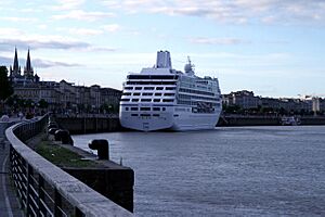
The Garonne is important for boats and ships. Large ships can sail from the Atlantic Ocean through the Gironde estuary and up the Garonne to the port of Bordeaux. Smaller inland boats can travel even further upstream to Castets-en-Dorthe.
The Garonne is also part of the Canal des Deux Mers (Canal of the Two Seas). This system of canals connects the Mediterranean Sea to the Atlantic Ocean. Before a special canal called the Canal latéral à la Garonne was built (between 1838 and 1856), smaller boats used to travel directly on the Garonne all the way to Toulouse. However, this part of the river was tricky to navigate. Now, the lateral canal, with its 53 locks, takes boats to Toulouse, where it connects with the famous Canal du Midi.
How the Garonne Gets Its Water
The upper part of the Garonne River, upstream from Toulouse, gets most of its water from melting snow in the mountains. The lower part of the river, and its main branches, get their water mostly from rainfall.
The Garonne also supplies water to several canals:
- The Saint-Martory canal takes water from the river.
- The canal latéral à la Garonne gets its water from the Garonne in Toulouse through the Brienne canal.
When the Garonne Floods
The Garonne River has caused many floods, especially in the city of Toulouse, where many people live along its banks.
Records show floods happening as far back as 1177. Some of the most notable floods in recent centuries include:
- In 1827, the water level in Toulouse rose four meters above normal.
- In 1835, it rose five meters above normal.
- The biggest flood in recent history was in 1875, when the water reached 9.70 meters at the Pont-Neuf bridge in Toulouse.
- Other significant floods occurred in 1930, 1952, 1977, 2000, and 2004.
In 1777, there was such a huge flood that a local priest even wrote about it in the church records!
Images for kids
See also
 In Spanish: Río Garona para niños
- List of rivers of Europe
 | Precious Adams |
 | Lauren Anderson |
 | Janet Collins |


