
Baïse facts for kids
Quick facts for kids Baïse |
|
| River | |
 Canal bridge over the Baïse river
|
|
| Country | France |
|---|---|
| Regions | Occitanie, Nouvelle-Aquitaine |
| Department | Hautes-Pyrénées, Gers, Lot-et-Garonne |
| Communes | Lannemezan, Trie-sur-Baïse, Mirande, Castéra-Verduzan, Valence-sur-Baïse |
| Tributaries | |
| - left | Gélise |
| - right | Baïsole, Petite Baïse, Auloue |
| City | Auch |
| Source | Pyrenees |
| - location | Plateau de Lannemezan, Occitanie, France |
| - elevation | 600 m (1,969 ft) |
| - coordinates | 43°06′17″N 0°21′20″E / 43.10472°N 0.35556°E |
| Mouth | Garonne |
| - location | Saint-Léger, Nouvelle-Aquitaine, France |
| - elevation | 30 m (98 ft) |
| - coordinates | 44°17′07″N 0°19′17″E / 44.28528°N 0.32139°E |
| Length | 188 km (117 mi) |
| Basin | 2,910 km² (1,124 sq mi) |
| Discharge | for Nérac |
| - average | 11.70 m³/s (413 cu ft/s) |
The Baïse (pronounced like "Bye-ez") is a lovely river in France. It's also sometimes called the Grande Baïse. It flows through several areas in France, including the Hautes-Pyrénées, Gers, and Lot-et-Garonne departments. These are parts of the Occitanie and Nouvelle-Aquitaine regions.
The river starts high up in the Pyrenees mountains. It then flows mostly from south to north. The Baïse eventually joins the larger Garonne River.
Contents
About the Baïse River
The Baïse river is about 188 kilometers (117 miles) long. It collects water from a large area called its drainage basin, which covers about 2,910 square kilometers (1,124 square miles).
River Flow and Water Levels
The amount of water flowing in the Baïse river changes throughout the year. On average, about 11.70 cubic meters (413 cubic feet) of water flow past Nérac every second. Nérac is a small town about 20 kilometers (12 miles) from where the Baïse meets the Garonne river.
The river usually has the most water during winter and spring. For example, in February, the flow can be around 23.00 cubic meters (812 cubic feet) per second. This is because of more rain and melting snow.
Where the Baïse Starts and Ends
The Baïse river begins on a high area called the Plateau de Lannemezan. This is in the Hautes-Pyrénées department, at an altitude of about 600 meters (1,968 feet) above sea level.
As it flows, the Baïse passes through 2 regions and 3 departments in France. It goes through 52 different communes (which are like small towns or local areas). Some of these places include:
- In the Occitanie region:
- Lannemezan
- Trie-sur-Baïse
- In the Nouvelle-Aquitaine region:
- Moncrabeau
- Nérac
- Lavardac
- Buzet-sur-Baïse
The Baïse river finishes its journey by flowing into the Garonne River. This happens near the town of Saint-Léger in the Lot-et-Garonne department. At this point, the river is about 30 meters (98 feet) above sea level.
Main Rivers Joining the Baïse
Smaller rivers that flow into a larger river are called tributaries. The Baïse river has several important tributaries:
- Rivers joining from the left side:
- Gélise - about 92 kilometers (57 miles) long.
- Rivers joining from the right side:
- Baïsole - about 47 kilometers (29 miles) long.
- Petite Baïse - about 74.8 kilometers (46.5 miles) long.
- Auloue - about 45.3 kilometers (28.1 miles) long.
Images for kids
-
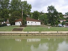
A Port on the Baïse river in Valence-sur-Baïse.
-
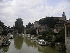
The Baïse river as it flows through Nérac.
-
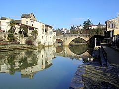
The old bridge crossing the Baïse river at Nérac.


See also
 In Spanish: Río Baïse para niños
