
Nérac facts for kids
Quick facts for kids
Nérac
|
||
|---|---|---|
|
Subprefecture and commune
|
||

The castle of Nérac
|
||
|
||

Nérac
Location in France

Nérac
Location in Nouvelle-Aquitaine
|
||
| Country | France | |
| Region | Nouvelle-Aquitaine | |
| Department | Lot-et-Garonne | |
| Arrondissement | Nérac | |
| Canton | L'Albret | |
| Intercommunality | Val d'Albret | |
| Area
1
|
62.68 km2 (24.20 sq mi) | |
| Population
(2014)
|
7,085 | |
| • Density | 113.034/km2 (292.76/sq mi) | |
| Demonym(s) | Néracais | |
| Time zone | UTC+01:00 (CET) | |
| • Summer (DST) | UTC+02:00 (CEST) | |
| INSEE/Postal code |
47195 /47600
|
|
| Elevation | 38–191 m (125–627 ft) (avg. 115 m or 377 ft) |
|
| Website | www.ville-nerac.fr | |
| 1 French Land Register data, which excludes lakes, ponds, glaciers > 1 km2 (0.386 sq mi or 247 acres) and river estuaries. | ||
.svg)
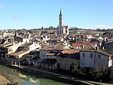
Nérac (which is Nerac in the Occitan language) is a charming town in south-western France. It's a special type of town called a commune. Nérac is located in the Nouvelle-Aquitaine region and is a sub-prefecture of the Lot-et-Garonne department. This means it's an important administrative center for the area. It's also the main town of the Arrondissement of Nérac and the Canton of L'Albret.
Contents
Exploring Nérac's Geography
Nérac is found in a natural area called Pays d'Albret, which is part of Gascony. This region is in the southern part of the Lot-et-Garonne department. The town covers an area of about 62.68 square kilometers (or 24.2 square miles). The average height above sea level in Nérac is about 115 meters (377 feet). At the town hall, it's about 56 meters (184 feet) high.

Nérac is surrounded by several other towns. These include Lavardac, Feugarolles, Espiens, Calignac, Fieux, Lasserre, Fréchou, Andiran, Réaup-Lisse, and Barbaste.
 |
Lavardac | Feugarolles | Espiens | |
| Barbaste | Calignac | |||
| Andiran and Réaup-Lisse | Fréchou | Fieux and Lasserre |
The Baïse river flows right through the town of Nérac, adding to its beauty. Another river, the Gélise, which flows into the Baïse, forms the western border of the commune.
Nérac's Population Over Time
The people who live in Nérac are called Néracais (for men) or Néracaises (for women) in French.
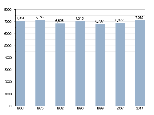
Nérac has a population of 7,085 people. This means there are about 113 people living in each square kilometer of the town.
How Nérac's Population Has Changed
How Nérac is Governed
Nérac has been a subprefecture in the Lot-et-Garonne department since the year 1800. This means it's a local government center. It's also the main town of the arrondissement of Nérac. Plus, it's the administrative centre (or chef-lieu in French) of the Canton of L'Albret. This canton is made up of 22 different communes and had 16,859 people living there in 2014.
Nérac's Twin Towns
Nérac has special friendships with other towns around the world. These are called twin towns:
 Madridejos, in the Toledo area of Spain, since 1995.
 Mesola, in the Ferrara area of Italy, since 2007.
Cool Places to See in Nérac
Nérac has some interesting historical sites and landmarks:
- Château de Nérac: This is the famous Nérac castle.
- Church of Saint-Nicolas: A beautiful old church.
- Pont-vieux: This means "Old Bridge" and it crosses the Blaïse river.
Nérac Photo Gallery
-
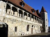
Château de Nérac
-
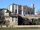
Saint-Nicolas church
-
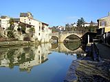
Pont-vieux
-
Le petit Nérac


More About Nérac
See also
 In Spanish: Nérac para niños
