
Province of Ferrara facts for kids
Quick facts for kids
Province of Ferrara
|
|
|---|---|

Castello Estense, Ferrara
|
|

Map with the province of Ferrara, in red, in Italy
|
|
| Country | |
| Region | Emilia-Romagna |
| Capital | Ferrara |
| Comuni | 23 |
| Area | |
| • Total | 2,635.12 km2 (1,017.43 sq mi) |
| Population
(January 2017)
|
|
| • Total | 348,362 |
| • Density | 132.1997/km2 (342.3956/sq mi) |
| Time zone | UTC+1 (CET) |
| • Summer (DST) | UTC+2 (CEST) |
| Postal code |
44000-44124
|
| Telephone prefix | 0532, 0533 |
| ISO 3166 code | IT-FE |
| Vehicle registration | FE |
| ISTAT | 038 |
| Website | Official website: http://www.provincia.fe.it/ |
The Province of Ferrara (which in Italian is provincia di Ferrara) is a special area in Northeast Italy. It is part of the Emilia-Romagna region and is located right next to the Adriatic Sea. The main city and capital of this province is Ferrara.
Contents
Geography of Ferrara Province
The Province of Ferrara is the northernmost part of the Emilia-Romagna region. It covers an area of about 2,635 square kilometers (1,017 square miles). The capital city, Ferrara, is located on a branch of the Po River. It is about 50 kilometers (31 miles) northeast of Bologna, which is the capital of the entire Emilia-Romagna region.
Borders of the Province
The Province of Ferrara shares its borders with several other areas:
- To the north, it borders the province of Rovigo in the Veneto region.
- To the northwest, it meets the province of Mantua in Lombardy.
- To the west, it is next to the Modena and Bologna provinces.
- To the south, it borders the province of Ravenna.
- To the east, it touches the Adriatic Sea.
 |
Mantua (province) (Lombardy) |
Rovigo (province) (Veneto region) |
|
|
| Modena (province) Bologna (province) |
Adriatic Sea | |||
| Ravenna (province) |
Flat Lands and Rivers
This province is very flat. Its highest point is less than 100 meters (328 feet) above sea level. This high point is found in the western part, near the border with the Modena province. Most of the towns, called comuni, are less than 10 meters (33 feet) above sea level. The town with the highest average altitude is Sant'Agostino.
The two most important rivers in the province are the Po and the Reno. The Po River forms the northern border of the province with the province of Rovigo. In Ferrara, the Po River splits into three main branches:
- The Po di Volano, which flows through the city of Ferrara.
- The Po di Primaro.
- The Po di Goro.
The Reno River is the longest river in the Emilia-Romagna region that does not flow into the Po River.
Lakes in Ferrara Province
The main lakes in the province are:
- The Lago delle Nazioni (meaning "Nation's Lake"), which is a lake made by people.
- The Lago del Quaternario.
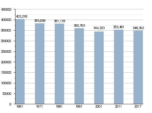
Population of Ferrara Province
As of January 2017, there were 348,362 people living in the Province of Ferrara. This means there were about 132 people living in each square kilometer (342 people per square mile).
How the population has changed over time:
Towns and Villages (Municipalities)
The Province of Ferrara has 23 towns and villages, which are called comuni in Italy. The table below shows their population, area, and how high they are above sea level.
| No. | Comune | Population (2017) |
Area (km²) |
Density | Altitude |
|---|---|---|---|---|---|
| 1 | Argenta | 21,641 | 311.67 | 69.4 | 4 |
| 2 | Berra | 4,785 | 68.64 | 69.7 | 2 |
| 3 | Bondeno | 14,440 | 174.76 | 82.6 | 11 |
| 4 | Cento | 35,582 | 64.74 | 549.6 | 15 |
| 5 | Codigoro | 11,852 | 170.01 | 69.7 | 3 |
| 6 | Comacchio | 22,369 | 284.13 | 78.7 | 0 |
| 7 | Copparo | 16,428 | 157,01 | 104.6 | 5 |
| 8 | Ferrara | 132,009 | 405.16 | 325.8 | 9 |
| 9 | Fiscaglia | 9,031 | 116.18 | 77.7 | 2 |
| 10 | Formignana | 2,731 | 22.43 | 121.8 | 3 |
| 11 | Goro | 3,761 | 33.18 | 113.4 | 1 |
| 12 | Jolanda di Savoia | 2,923 | 108.34 | 27.0 | 1 |
| 13 | Lagosanto | 4,874 | 34.44 | 141.5 | 0 |
| 14 | Masi Torello | 2,319 | 22.71 | 102.1 | 3 |
| 15 | Mesola | 6,852 | 84.31 | 81.3 | 1 |
| 16 | Ostellato | 6,129 | 173.34 | 35.4 | 2 |
| 17 | Poggio Renatico | 9,869 | 80.23 | 123.0 | 10 |
| 18 | Portomaggiore | 11,756 | 126.64 | 92.8 | 3 |
| 19 | Ro | 3,247 | 43.20 | 75.2 | 5 |
| 20 | Terre del Reno | 10,004 | 51.04 | 196.0 | 19 |
| 21 | Tresigallo | 4,434 | 20.62 | 215.0 | 1 |
| 22 | Vigarano Mainarda | 7,590 | 42.02 | 180.6 | 10 |
| 23 | Voghiera | 3,736 | 40.33 | 92.6 | 7 |
See also
 In Spanish: Provincia de Ferrara para niños
