
Reno (river) facts for kids
Quick facts for kids Reno |
|
| River | |
.jpg) The Reno in Casalecchio di Reno
|
|
| Country | Italy |
|---|---|
| State | Northern Italy |
| Regions | Tuscany, Emilia-Romagna |
| Provinces | Pistoia, Ferrara, Bologna, Ravenna |
| Comuni | Sasso Marconi, Casalecchio di Reno, Bologna, Cento, Argenta |
| Tributaries | |
| - left | Silla, Samoggia |
| - right | Setta, Idice, Savena, Sillaro, Santerno, Senio |
| Cities | Bologna, Cento, Argenta |
| Source | |
| - location | Northern Apennines, Tuscany, Italy |
| - elevation | 745 m (2,444 ft) |
| - coordinates | 44°0′33″N 10°49′39″E / 44.00917°N 10.82750°E |
| Mouth | Adriatic Sea |
| - location | Comacchio, Emilia-Romagna, Italy |
| - elevation | 0 m (0 ft) |
| - coordinates | 44°35′47″N 12°16′49″E / 44.59639°N 12.28028°E |
| Length | 211 km (131 mi) |
| Basin | 4,628 km² (1,787 sq mi) |
| Discharge | |
| - average | 95 m³/s (3,355 cu ft/s) |
The Reno River is an important river in northeastern Italy. It begins high up in the Northern Apennines mountains in a region called Tuscany. But most of its journey is through another region, Emilia-Romagna. The Reno is one of the longest rivers in Italy, flowing for many kilometers.
Contents
The Reno River's Journey
The Reno River is about 211 kilometers (131 miles) long. The area of land that drains into the Reno River is about 4,628 square kilometers (1,787 square miles).
Where the River Starts
The Reno River begins in the Apennines mountains. This is northwest of the city of Pistoia in the Pistoia province of Tuscany. The Reno is formed when two smaller streams, the Reno di Prunetta and the Reno di Campolungo, join together. This happens about 745 meters (2,444 feet) above sea level.
The River's Path
At first, the Reno River flows west. In this part, it forms the border between Tuscany and Emilia-Romagna. You can see several man-made lakes here. These lakes are created by dams. The dams are used to make hydro-electric energy. This is a way to create electricity using the force of water.
Later, near a town called Sant'Agostino, the river turns southwest. It then flows west of the big city of Bologna, passing through Casalecchio di Reno. As the Reno River gets closer to the sea, many other streams flow into it. Some of these streams only have water when it rains.
The Reno River used to flow into the Po River. But in the mid-1700s, its path was changed. This was done to prevent frequent floods. Now, the Reno River flows directly into the Adriatic Sea. It meets the sea near Casalborsetti, which is southeast of the Valli di Comacchio. This is a lagoon area near the town of Comacchio.
Cities Along the Reno
The Reno River flows through many towns and cities. Here are some of the important ones in the Emilia-Romagna region:
- In the Province of Bologna:
- Porretta Terme
- Vergato
- Marzabotto
- Sasso Marconi
- Casalecchio di Reno
- Bologna
- In the Province of Ferrara:
- Cento
- Argenta
- Comacchio
Rivers That Join the Reno
Many smaller rivers and streams, called tributaries, flow into the Reno River. They add their water to the Reno as it makes its way to the sea.
Tributaries from the Left Side
- Silla: This river is about 18 kilometers (11 miles) long.
- Samoggia: This river is about 44 kilometers (27 miles) long.
Tributaries from the Right Side
- Limentra di Sambuca: About 19.4 kilometers (12 miles) long.
- Eastern Limentra: About 41 kilometers (25 miles) long.
- Setta: About 47 kilometers (29 miles) long.
- Idice: About 80 kilometers (50 miles) long.
- Savena: This river is about 54 kilometers (34 miles) long and flows into the Idice.
- Sillaro: About 66 kilometers (41 miles) long.
- Santerno: This is the most important tributary from the right side. It is about 103 kilometers (64 miles) long. It also adds the most water to the Reno.
- Senio: About 92 kilometers (57 miles) long.
More About Rivers
Images for kids
-
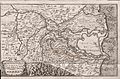
Reno river in 18th century

See also
 In Spanish: Río Reno para niños
