
Province of Ravenna facts for kids
Quick facts for kids
Province of Ravenna
|
||
|---|---|---|

Piazza del Popolo, Ravenna
|
||
|
||

Map with the province of Ravenna, in red, in Italy
|
||
| Country | ||
| Region | Emilia-Romagna | |
| Capital | Ravenna | |
| Comuni | 18 | |
| Area | ||
| • Total | 1,859.44 km2 (717.93 sq mi) | |
| Population
(January 2017)
|
||
| • Total | 391,414 | |
| • Density | 210.5010/km2 (545.1951/sq mi) | |
| Time zone | UTC+1 (CET) | |
| • Summer (DST) | UTC+2 (CEST) | |
| Postal code |
48010-48015, 48017, 48018, 48020, 48022, 48024-48027, 48100
|
|
| Telephone prefix | 0544, 0545, 0546 | |
| ISO 3166 code | IT-RA | |
| Vehicle registration | RA | |
| ISTAT | 039 | |
| Website | Official website: http://www.provincia.ra.it/ | |

The Province of Ravenna (in Italian, provincia di Ravenna) is a special area in Northeast Italy. It's part of the Emilia-Romagna region and is located right by the Adriatic Sea. The main city, or capital, of this province is Ravenna.
Contents
A Look Back in Time
The Province of Ravenna was officially created in the year 1859. This means it has a long history as a recognized area in Italy.
Exploring Ravenna's Geography

The Province of Ravenna is found in the eastern part of the Emilia-Romagna region. It stretches along the beautiful Adriatic Sea.
Size and Location
This province covers an area of about 1,859 square kilometers (718 square miles). The capital city, Ravenna, is quite close to the sea, only about 8 kilometers (5 miles) away. It's also about 68 kilometers (42 miles) southeast of Bologna, which is the capital city of the Emilia-Romagna region.
Neighboring Areas
The Province of Ravenna shares its borders with several other provinces:
- To the north, it borders the province of Ferrara.
- To the west, it meets the Metropolitan City of Bologna.
- To the southwest, it touches the province of Florence in Tuscany.
- To the south, it borders the province of Forlì-Cesena.
 |
Ferrara (province) | |
||
| Bologna (province) | Adriatic Sea | |||
| Florence (province) (Tuscany) |
Forlì-Cesena (province) |
Highest Point and Rivers
The highest point in the province is a mountain called Monte Macchia dei Cani. It stands tall at 966 meters (3,169 feet) above sea level.
Several important rivers flow through the province. Here are some of the main ones:
- Reno - 211 km (131 miles) long
- Lamone - 90 km (56 miles) long
- Senio - 92 km (57 miles) long
- Uniti - 12 km (7.5 miles) long
- Montone - 140 km (87 miles) long
- Bidente-Ronco - 135 km (84 miles) long
- Bevano - 33 km (21 miles) long
- Savio - 126 km (78 miles) long
Climate in Ravenna
The coastal area of Punta Marina Terme, which is part of Ravenna, has a specific type of climate. It's known for having fairly warm temperatures and rain throughout the year. This climate is called a "Humid Subtropical Climate."
On average, Punta Marina Terme gets about 604.5 millimeters (23.8 inches) of rain each year. November is usually the wettest month, while February is the driest. The area experiences about 71 days of rain per year.
The average temperature for the whole year in Punta Marina Terme is about 13.4°C (56.1°F). July is the warmest month, with temperatures averaging around 23.2°C (73.8°F). January is the coolest month, with an average temperature of about 2.8°C (37.0°F).
People of Ravenna Province
As of January 2017, there were 391,414 people living in the Province of Ravenna. This means there are about 210.5 people living in each square kilometer (545 people per square mile).
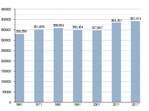
Population Changes Over Time
The graph below shows how the number of people living in the province has changed over the years. You can see how the population has grown or shrunk at different times.
How the Province is Managed
The Province of Ravenna is divided into 18 smaller areas called comuni (singular: comune). Each comune is like a local town or city with its own government.
The table below lists all 18 comuni in the province. It also shows how many people live in each one, their total area, how many people live per square kilometer (density), and their height above sea level (altitude).
| No. | Comune | Population (2017) |
Area (km²) |
Density | Altitude |
|---|---|---|---|---|---|
| 1. | Alfonsine | 11,993 | 106.79 | 112.3 | 6 |
| 2. | Bagnacavallo | 16,686 | 79.58 | 209.7 | 11 |
| 3. | Bagnara di Romagna | 2,432 | 9.96 | 244.2 | 22 |
| 4. | Brisighella | 7,629 | 194.33 | 39.3 | 115 |
| 5. | Casola Valsenio | 2,650 | 84.42 | 31.4 | 195 |
| 6. | Castel Bolognese | 9,594 | 32.37 | 296.4 | 42 |
| 7. | Cervia | 28,794 | 82.27 | 350.0 | 5 |
| 8. | Conselice | 9,783 | 60.20 | 162.5 | 6 |
| 9. | Cotignola | 7,487 | 35.14 | 213.1 | 19 |
| 10. | Faenza | 58,836 | 215.76 | 272.7 | 35 |
| 11. | Fusignano | 8,155 | 24.55 | 332.2 | 9 |
| 12. | Lugo | 32,396 | 117.06 | 276.7 | 12 |
| 13. | Massa Lombarda | 10,578 | 37.25 | 284.0 | 13 |
| 14. | Ravenna | 159,057 | 653.82 | 243.3 | 4 |
| 15. | Riolo Terme | 5,683 | 44.26 | 128.4 | 98 |
| 16. | Russi | 12,308 | 46.26 | 266.1 | 13 |
| 17. | Sant'Agata sul Santerno | 2,880 | 9.37 | 307.4 | 14 |
| 18. | Solarolo | 4,473 | 26.04 | 171.8 | 25 |
See also
 In Spanish: Provincia de Rávena para niños
