Savio (river) facts for kids
Quick facts for kids Savio |
|
| River | |
|
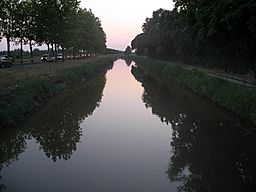
The Savio river in Lido di Savio
|
|
| Country | Italy |
|---|---|
| Region | Emilia-Romagna |
| Provinces | Forlì-Cesena, Ravenna |
| Comuni | Verghereto, Bagno di Romagna, San Piero in Bagno, Sarsina, Mercato Saraceno, Cesena, Cervia, Ravenna |
| Tributaries | |
| - left | Botello |
| - right | Para |
| City | Cesena |
| Source | Mount Fumaiolo |
| - location | Verghereto, Forlì-Cesena, Italy |
| - elevation | 1,126 m (3,694 ft) |
| Mouth | Adriatic Sea |
| - location | Lido di Savio, Ravenna, Italy |
| - coordinates | 44°19′10″N 12°20′30″E / 44.31944°N 12.34167°E |
| Length | 126 km (78 mi) |
| Discharge | |
| - average | 6 m³/s (212 cu ft/s) |
The Savio River, also known as Sapis in Latin, is a river in Italy. It begins high up in the Apennines mountains and flows east until it reaches the Adriatic Sea. It's the longest river in the Romagna region of Italy.
Contents
River Facts: Length and Flow
The Savio River is about 126 km (78 mi) long. It also has a large drainage basin, which is the area of land where all the rain and snow melt flows into the river. This area is about 700 km2 (270 sq mi).
The amount of water flowing in the river, called its discharge, changes throughout the year. In autumn, when there's more rain, the river can carry as much as 1,000 cubic metres of water every second. But in summer, it carries much less. Most of the time, the river's flow is around 6 cubic metres per second.
Where the Savio River Starts
The Savio River begins as a small stream called Fosso Grosso. Its source is on Mount Fumaiolo, a mountain in the Apennines. The river starts at a height of about 1,126 m (3,694 ft). This spot is in the commune of Verghereto, right on the border between the Tuscany and Emilia-Romagna regions. At the very beginning of the river, there's a special monument with symbols of the Romagna region and the Verghereto commune.
The River's Journey
In a small village called Montecoronaro, which is part of Verghereto, the river officially becomes known as the Savio. The river then flows through the towns of Bagno di Romagna and San Piero in Bagno. After a few kilometres, it forms an artificial lake called Lago di Quarto. Here, another important stream called Para joins the Savio from the right side.
The Savio continues its journey through the towns of Sarsina, Mercato Saraceno, and Cesena. All these towns are in the province of Forlì-Cesena. In Botello, another small village near Cesena, the main stream that feeds the Savio, called Botello, joins it from the left side. After this, the river enters the province of Ravenna. It flows past Castiglione di Cervia (in the commune of Cervia) and Castiglione di Ravenna (in the commune of Ravenna).
Finally, after traveling 126 kilometers, the Savio River flows into the Adriatic Sea. It meets the sea between two popular beach towns: Lido di Classe and Lido di Savio.
Main Streams Joining the Savio
The streams that flow into the Savio River are all quite small. The most important ones are the Botello, which joins from the left, and the Para, which joins from the right.
 | DeHart Hubbard |
 | Wilma Rudolph |
 | Jesse Owens |
 | Jackie Joyner-Kersee |
 | Major Taylor |


