Gélise facts for kids
Quick facts for kids Gélise |
|
| River | |
|
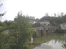
The Gélise river at Barbaste
|
|
| Country | France |
|---|---|
| Regions | Occitanie, Nouvelle-Aquitaine |
| Department | Gers, Landes, Lot-et-Garonne |
| Communes | Demu, Eauze, Sos, Poudenas, Mézin, Barbaste |
| Tributaries | |
| - left | Rimbez, Gueyze |
| - right | Izaute, Auzoue, Osse |
| City | Nérac |
| Source | Pyrénées |
| - location | Lupiac, Gers, France |
| - elevation | 215 m (705 ft) |
| - coordinates | 43°41′02″N 0°10′38″E / 43.68389°N 0.17722°E |
| Mouth | Baïse |
| - location | Lavardac, Lot-et-Garonne, France |
| - elevation | 40 m (131 ft) |
| - coordinates | 44°10′47″N 0°17′18″E / 44.17972°N 0.28833°E |
| Length | 92 km (57 mi) |
| Basin | 2,910 km² (1,124 sq mi) |
| Discharge | for Mézin |
| - average | 4.72 m³/s (167 cu ft/s) |
The Gélise is a river in the southwestern part of France. It flows through three different areas called "departments": Gers, Landes, and Lot-et-Garonne. These departments are part of two larger regions: Occitanie and Nouvelle-Aquitaine. The Gélise river is a "tributary" of the Baïse river, which means it flows into the Baïse.
Contents
About the Gélise River
The Gélise river is about 92 kilometers (or 57 miles) long. The area of land where all the water flows into the Gélise is called its "drainage basin." This area is quite large, covering about 2,859 square kilometers (about 1,104 square miles).
How Much Water Flows?
The amount of water that flows through the Gélise river each second is called its "discharge." On average, about 4.72 cubic meters of water flow through the river every second near the town of Mézin. Imagine a cube of water that's about 1.6 meters (or 5 feet) on each side – that's how much water passes by every second!
Where the River Starts and Ends
The Gélise river begins in a place called Cahuzères in the town of Lupiac, which is in the Gers department. It starts high up, about 215 meters (or 705 feet) above sea level.
The river first flows towards the northwest. Then, after passing the town of Castelnau-d'Auzan, it changes direction and flows towards the northeast. The Gélise river eventually joins the Baïse river at a town called Lavardac. This is much lower down, at about 40 meters (or 131 feet) above sea level.
The Gélise river flows through many towns and villages. Some of these include:
- In the Occitanie region:
* Gers: Dému, Eauze, Lupiac
- In the Nouvelle-Aquitaine region:
* Landes: Parleboscq, Escalans * Lot-et-Garonne: Sos, Poudenas, Mézin, Barbaste, Nérac, Lavardac
Main Rivers Joining the Gélise
A "tributary" is a smaller river or stream that flows into a larger river. The Gélise river has several important tributaries that add to its water.
Tributaries from the Left Side
- Rimbez: This river is about 16.4 kilometers (10.2 miles) long.
- Gueyze: This river is about 17.7 kilometers (11 miles) long.
Tributaries from the Right Side
- Izaute: This river is about 37.5 kilometers (23.3 miles) long.
- Auzoue: This river is about 74.1 kilometers (46 miles) long.
- Osse: This is the longest tributary, at about 120.2 kilometers (74.7 miles) long.
Related pages
 | Precious Adams |
 | Lauren Anderson |
 | Janet Collins |


