
Gers facts for kids
Quick facts for kids
Gers
|
|||
|---|---|---|---|

Prefecture building of the Gers department, in Auch
|
|||
|
|||

Location of Gers in France
|
|||
| Country | France | ||
| Region | Occitanie | ||
| Département | 4 March 1790 | ||
| Prefecture | Auch | ||
| Area | |||
| • Total | 6,256.8 km2 (2,415.8 sq mi) | ||
| Population
(2014)
|
|||
| • Total | 190,625 | ||
| • Density | 30.4669/km2 (78.9088/sq mi) | ||
| Demonym(s) | Gersois | ||
| Time zone | UTC+1 (CET) | ||
| • Summer (DST) | UTC+2 (CEST) | ||
| ISO 3166 code | FR-32 | ||
| Arrondissements | 3 | ||
| Cantons | 17 | ||
| Communes | 462 | ||
| Website | www.gers.fr/ | ||


Gers is a department in southwest France. It is part of the Occitanie region. The department is named after the Gers river.
Contents
History of Gers
Gers is one of the 83 French departments. It was created on March 4, 1790. This happened during the French Revolution. The department was formed from parts of old areas like Guyenne and Gascony.
The main city, or prefecture, was Auch. In 1808, a small part of Gers was moved to the new Tarn-et-Garonne department.
Exploring Gers' Geography

Gers is known for its hilly landscape. You can also see many old bastide villages here. The tall Pyrenees mountains are visible to the south.
Gers is part of the Occitanie region. It is the 34th largest department in France. Its total area is about 6,256.8 km2 (2,416 sq mi).
Neighboring Departments
Gers is surrounded by six other departments. They are in two different regions:
- Nouvelle-Aquitaine region:
- Lot-et-Garonne (to the north)
- Pyrénées-Atlantiques (to the southwest)
- Landes (to the west)
- Occitanie region:
- Tarn-et-Garonne (to the northeast)
- Haute-Garonne (to the east)
- Hautes-Pyrénées (to the south)
 |
Lot-et-Garonne | Tarn-et-Garonne | |
|
| Landes | Haute-Garonne | |||
| Pyrénées-Atlantiques | Hautes-Pyrénées |
Rivers and Highest Point
The main rivers in Gers are the Garonne and the Gers. The Gers river flows into the Garonne. Other rivers include the Save, Gimone, Arrats, Baïse, and Osse.
The highest point in the department is Mont de Chapelle Saint Roch. It is about 377 m (1,237 ft) tall. This mountain is in the west-central Pyrenees. It is close to the border with the Hautes-Pyrénées department.
Gers' Climate
Gers has an oceanic climate. This means it has warm summers. In the Köppen climate classification, it's called Cfb.
The amount of rain changes across the department. The southwest gets over 900 mm (35.4 in) of rain each year. The northeast gets less than 700 mm (27.6 in).
Summers are often very hot and dry. Temperatures can go above 40 °C (104 °F). Winters can have frost, but they are usually mild and dry.
| Climate data for Auch, Gers, France | |||||||||||||
|---|---|---|---|---|---|---|---|---|---|---|---|---|---|
| Month | Jan | Feb | Mar | Apr | May | Jun | Jul | Aug | Sep | Oct | Nov | Dec | Year |
| Mean daily maximum °C (°F) | 10.2 (50.4) |
11.8 (53.2) |
15.1 (59.2) |
17.6 (63.7) |
21.5 (70.7) |
25.3 (77.5) |
27.9 (82.2) |
27.9 (82.2) |
24.9 (76.8) |
19.9 (67.8) |
13.7 (56.7) |
10.4 (50.7) |
18.9 (65.9) |
| Daily mean °C (°F) | 5.9 (42.6) |
6.8 (44.2) |
9.5 (49.1) |
11.9 (53.4) |
15.8 (60.4) |
19.4 (66.9) |
21.6 (70.9) |
21.4 (70.5) |
18.5 (65.3) |
14.5 (58.1) |
9.3 (48.7) |
6.3 (43.3) |
13.4 (56.1) |
| Mean daily minimum °C (°F) | 1.5 (34.7) |
1.7 (35.1) |
3.9 (39.0) |
6.2 (43.2) |
10 (50) |
13.4 (56.1) |
15.2 (59.4) |
14.9 (58.8) |
12 (54) |
9.1 (48.4) |
4.8 (40.6) |
2.1 (35.8) |
7.9 (46.3) |
| Average rainfall mm (inches) | 40.3 (1.59) |
31.6 (1.24) |
37.8 (1.49) |
61.4 (2.42) |
84.6 (3.33) |
68.4 (2.69) |
58.8 (2.31) |
64.3 (2.53) |
75 (3.0) |
72.1 (2.84) |
54.6 (2.15) |
43.1 (1.70) |
692 (27.29) |
| Source: Weatherbase.com [1] | |||||||||||||
How Gers is Governed
The department is run by the Departmental Council of the Gers. This council is located in Auch. Gers is part of the larger Occitanie region.
People of Gers
The people who live in Gers are called Gersois (for men) and Gersoises (for women) in French.
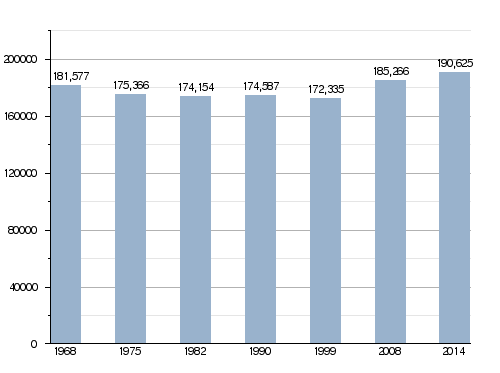
In 2014, Gers had a population of 190,625 people. This means there were about 30.5 people per square kilometer.
Evolution of the population in Gers

Gers' Economy
The economy in Gers mainly focuses on agriculture and food-related tourism. The department grows a lot of maize, wheat, rapeseed, and sunflower.
Some famous products from this region are:
- Armagnac: a type of brandy.
- Côtes de Gascogne: a local wine.
- Floc de Gascogne: an apéritif, which is an alcoholic drink served before a meal.
- Foie gras: a special food made from duck or goose liver.
- Wild mushrooms: found in the area.
Gallery


.JPG)
Related pages
- Arrondissements of the Gers department
- Communes of the Gers department
Images for kids
-
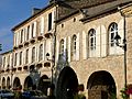
Montréal, Gers
-
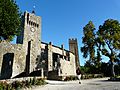
Larressingle
-
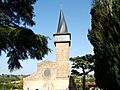
Barran


See also
 In Spanish: Gers (departamento) para niños
