
Haute-Garonne facts for kids
Quick facts for kids
Haute-Garonne
|
|||
|---|---|---|---|

Prefecture building of the Haute-Garonne department, in Toulouse
|
|||
|
|||

Location of Haute-Garonne in France
|
|||
| Country | France | ||
| Region | Occitanie | ||
| Département | 4 March 1790 | ||
| Prefecture | Toulouse | ||
| Subprefectures | Saint-Gaudens, Muret | ||
| Area | |||
| • Total | 6,309.3 km2 (2,436.0 sq mi) | ||
| Population
(2014)
|
|||
| • Total | 1,317,668 | ||
| • Rank | 13th | ||
| • Density | 208.8454/km2 (540.907/sq mi) | ||
| Demonym(s) | Haut-Garonnais, Haut-Garonnaise | ||
| Time zone | UTC+1 (CET) | ||
| • Summer (DST) | UTC+2 (CEST) | ||
| ISO 3166 code | FR-31 | ||
| Arrondissements | 3 | ||
| Cantons | 27 | ||
| Communes | 589 | ||
| Website | http://www.haute-garonne.fr/ | ||


Haute-Garonne is a special area in the southwest of France. It's called "Upper Garonne" because it's named after the Garonne river that flows through it. The biggest city and main office for the department is Toulouse.
Contents
A Look at Haute-Garonne's Past
Haute-Garonne was one of the first 83 departments created in France. This happened during the French Revolution on March 4, 1790. It was formed from a part of an older region called Languedoc.
The department used to be bigger. A district called Castelsarrasin was moved to a new department, Tarn-et-Garonne, in 1808.
Exploring Haute-Garonne's Geography
Haute-Garonne covers about 6,309 square kilometers (2,436 square miles). It is part of the Occitanie region in France. This department is not an old historical region. Instead, it's an administrative area made from parts of Languedoc and Gascogne.
Neighboring Regions and Countries
Haute-Garonne is surrounded by several other departments:
- Ariège to the southeast
- Aude to the east
- Tarn to the northeast
- Tarn-et-Garonne to the north
- Gers to the west
- Hautes-Pyrénées to the southwest
To the south, it shares a border with Spain. Specifically, it borders the Spanish provinces of Lleida and Huesca.
 |
Tarn-et-Garonne | Tarn | |
|
| Gers | Aude | |||
| Hautes-Pyrénées | Spain | Ariège |
The Garonne River and Its Plains
The Garonne river flows through Haute-Garonne for almost 200 kilometers (124 miles). The department's borders often follow the river's path. The Garonne enters France from Spain near the town of Fos. It then passes through Toulouse before leaving the department.
Two large canals also cross the department from east to west:
- The Canal du Midi
- The Canal de Garonne
Haute-Garonne has three main types of land:
- The far south is in the Pyrenees mountain range. This area has many tall mountains. The highest peak is Peak of Perdiguère, which is 3,221 meters (10,568 feet) above sea level.
- A first plain area is located north of the Pyrenees. It stretches from Montréjeau to Saint-Martory.
- A second, much larger plain is the Toulouse plain. This area extends from Saint-Martory to the northern edge of the department.
Haute-Garonne's Climate
The climate in Haute-Garonne is an oceanic climate, which means it has mild summers. This type of climate is known as Cfb in the Köppen climate classification system.
| Climate data for Toulouse, Haut-Garonne, France | |||||||||||||
|---|---|---|---|---|---|---|---|---|---|---|---|---|---|
| Month | Jan | Feb | Mar | Apr | May | Jun | Jul | Aug | Sep | Oct | Nov | Dec | Year |
| Mean daily maximum °C (°F) | 8 (46) |
11 (52) |
13 (55) |
16 (61) |
20 (68) |
25 (77) |
27 (81) |
27 (81) |
24 (75) |
18 (64) |
12 (54) |
9 (48) |
18 (64) |
| Daily mean °C (°F) | 4 (39) |
6 (43) |
8 (46) |
11 (52) |
14 (57) |
18 (64) |
21 (70) |
21 (70) |
18 (64) |
13 (55) |
8 (46) |
5 (41) |
12 (54) |
| Mean daily minimum °C (°F) | 1 (34) |
2 (36) |
3 (37) |
6 (43) |
9 (48) |
12 (54) |
15 (59) |
15 (59) |
12 (54) |
8 (46) |
5 (41) |
2 (36) |
8 (46) |
| Average rainfall mm (inches) | 40 (1.6) |
40 (1.6) |
50 (2.0) |
60 (2.4) |
70 (2.8) |
60 (2.4) |
30 (1.2) |
50 (2.0) |
50 (2.0) |
50 (2.0) |
60 (2.4) |
50 (2.0) |
610 (24.4) |
| Source: Weatherbase.com [1] | |||||||||||||
How Haute-Garonne is Managed
The department is run by the Departmental Council of the Haute-Garonne. This council is based in Toulouse. Haute-Garonne is also part of the larger Occitanie region.
Administrative Divisions of Haute-Garonne
Haute-Garonne is divided into smaller areas to help with its management. There are:
- 3 arrondissements (districts)
- 27 cantons (smaller administrative areas)
- 589 communes (municipalities or towns/villages)
Arrondissements of Haute-Garonne
Here are the arrondissements in the Haute-Garonne department:
| INSEE code |
Arrondissement | Capital | Population (2014) |
Area (km²) |
Density (Inh./km²) |
Communes |
|---|---|---|---|---|---|---|
| 311 | Muret | Muret | 215,606 | 1,639.0 | 131.5 | 126 |
| 312 | Saint-Gaudens | Saint-Gaudens | 77,545 | 2,139.6 | 36.2 | 237 |
| 313 | Toulouse | Toulouse | 1,024,517 | 2,530.7 | 404.8 | 226 |
Cantons of Haute-Garonne
This is a list of the 27 cantons in Haute-Garonne. These were reorganized in March 2015:
- Auterive (3101)
- Bagnères-de-Luchon (3102)
- Blagnac (3103)
- Castanet-Tolosan (3104)
- Castelginest (3105)
- Cazères (3106)
- Escalquens (3107)
- Léguevin (3108)
- Muret (3109)
- Pechbonnieu (3110)
- Plaisance-du-Touch (3111)
- Portet-sur-Garonne (3112)
- Revel (3113)
- Saint-Gaudens (3114)
- Toulouse-1 (3115)
- Toulouse-2 (3116)
- Toulouse-3 (3117)
- Toulouse-4 (3118)
- Toulouse-5 (3119)
- Toulouse-6 (3120)
- Toulouse-7 (3121)
- Toulouse-8 (3122)
- Toulouse-9 (3123)
- Toulouse-10 (3124)
- Toulouse-11 (3125)
- Tournefeuille (3126)
- Villemur-sur-Tarn (3127)
Population of Haute-Garonne
People who live in Haute-Garonne are called Haut-Garonnais (for men) or Haut-Garonnaises (for women) in French.
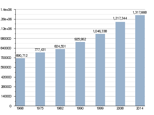
In 2014, Haute-Garonne had 1,317,668 people living there. This means there were about 208.9 people per square kilometer (541.1 people per square mile). The arrondissement of Toulouse is the largest, with 1,024,517 people. The other two, Muret and Saint-Gaudens, have 215,606 and 77,545 people, respectively.
Population Growth Over Time
Evolution of the population in Haute-Garonne
Top 10 Cities by Population
Here are the 10 cities with the most people living in them in Haute-Garonne, based on 2014 data:

| No. | City | Population (2014) |
Arrondissement |
|---|---|---|---|
| 1 | Toulouse | 466,297 | Toulouse |
| 2 | Colomiers | 38,541 | Toulouse |
| 3 | Tournefeuille | 26,674 | Toulouse |
| 4 | Muret | 24,975 | Muret |
| 5 | Blagnac | 23,416 | Toulouse |
| 6 | Plaisance-du-Touch | 17,278 | Toulouse |
| 7 | Cugnaux | 17,004 | Toulouse |
| 8 | Balma | 15,319 | Toulouse |
| 9 | Ramonville-Saint-Agne | 13,986 | Toulouse |
| 10 | Castanet-Tolosan | 12,640 | Toulouse |
Gallery
-
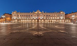
Capitole de Toulouse at night
-
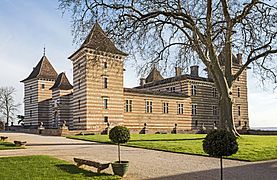
Château de Laréole
-
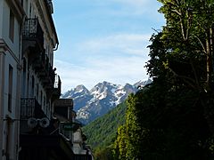
Pyrenees seen from Bagnères-de-Luchon
-
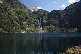
Lac d'Oô


Related pages
Images for kids
-
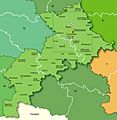
Map of Haute-Garonne with its main cities and towns
-
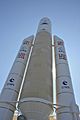
Cité de l'espace


See also
 In Spanish: Alto Garona para niños
