
Saint-Gaudens, Haute-Garonne facts for kids
Quick facts for kids
Saint-Gaudens
|
||
|---|---|---|
|
Subprefecture and commune
|
||

Church of Saint-Pierre-et-Saint-Gaudens
|
||
|
||

Saint-Gaudens
Location in France

Saint-Gaudens
Location in Occitanie
|
||
| Country | France | |
| Region | Occitanie | |
| Department | Haute-Garonne | |
| Arrondissement | Saint-Gaudens | |
| Canton | Saint-Gaudens | |
| Intercommunality | Saint-Gaudinois | |
| Area
1
|
27.4 km2 (10.6 sq mi) | |
| Population
(2014)
|
11,255 | |
| • Density | 410.8/km2 (1,063.9/sq mi) | |
| Demonym(s) | Saint-Gaudinois | |
| Time zone | UTC+01:00 (CET) | |
| • Summer (DST) | UTC+02:00 (CEST) | |
| INSEE/Postal code |
31483 /31800
|
|
| Elevation | 338–558 m (1,109–1,831 ft) (avg. 372 m or 1,220 ft) |
|
| Website | www.stgo.fr | |
| 1 French Land Register data, which excludes lakes, ponds, glaciers > 1 km2 (0.386 sq mi or 247 acres) and river estuaries. | ||
.svg)
Saint-Gaudens (in Gascon: Sent Gaudenç) is a town in southwestern France. It is located in the Haute-Garonne area, which is like a county. Saint-Gaudens is the main town of its own arrondissement and canton, which are types of administrative areas in France.
Contents
History of Saint-Gaudens

Long ago, in ancient times, the area where Saint-Gaudens is now was near a Roman road. This road connected the cities of Toulouse and Dax. There was a small rural area here called Mansus. Later, after people in the region became Christian, this place was renamed Mas Saint-Pierre.
In the year 475, a young Christian boy named Gaudens was killed by the Visigoths. He was buried in this very spot. Many people came to this place to worship him, and the town eventually took his name in the ninth century. The special items linked to Gaudens, called relics, were placed in the church of Mas-Saint-Pierre.
Saint-Gaudens grew into an important place for markets. It became the main economic center for the Comminges region. This region is a natural area with hills at the base of the Pyrenees mountains.
Geography of Saint-Gaudens
Saint-Gaudens is located in the Comminges region, right at the foot of the Pyrenees mountains. It is about 90 kilometers (56 miles) southwest of Toulouse. It is also about 70 kilometers (43 miles) from Tarbes.
The town is on the left side of the Garonne river.
The total area of Saint-Gaudens is 27.4 square kilometers (10.6 square miles). The average height above sea level is 372 meters (1,220 feet). At the town hall, the height is 401 meters (1,316 feet).
 |
Saux-et-Pomarède | Lieoux | |
|
| Villeneuve-de-Rivière | Landorthe | |||
| Miramont-de-Comminges and Valentine | Estancarbon |
Climate in Saint-Gaudens
Saint-Gaudens has an oceanic climate with mild summers. This type of climate is known as Cfb in the Köppen climate classification system. This means it has moderate temperatures all year round, with no dry season.
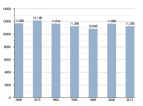
Population of Saint-Gaudens

People who live in Saint-Gaudens are called Saint-Gaudinois (for men) or Saint-Gaudinoises (for women) in French.
In 2014, Saint-Gaudens had a population of 11,255 people. This means there were about 411 people living in each square kilometer of the town.
How the population of Saint-Gaudens has changed over time
Administration of Saint-Gaudens
Saint-Gaudens is a subprefecture of the Haute-Garonne department. This means it's an important administrative center. It is the main town of its arrondissement and canton.
The town is also part of a group of communities called Cœur et Coteaux de Comminges. This group works together on different projects.
Sister cities
Saint-Gaudens has special friendships with other towns around the world. These are called "sister cities":
Places to visit in Saint-Gaudens
Here are some important buildings and places you can visit in Saint-Gaudens:
- The Saint-Pierre-et-Saint-Gaudens church
- The Saint-Jacques chapel
- The Cloister (this is part of an old monastery called Bonnefond Abbey)
Related pages
Images for kids
-
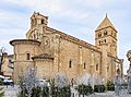
Church of Saint-Pierre-et-Saint-Gaudens.
-
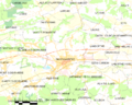
Map of the commune of Saint-Gaudens.

See also
 In Spanish: Saint-Gaudens para niños
