
Tarn facts for kids
Quick facts for kids
Tarn
|
|||
|---|---|---|---|

Old city and Tarn river, Albi
|
|||
|
|||

Location of Tarn in France
|
|||
| Country | France | ||
| Region | Occitanie | ||
| Département | 4 March 1790 | ||
| Prefecture | Albi | ||
| Subprefecture | Castres | ||
| Area | |||
| • Total | 5,757.9 km2 (2,223.1 sq mi) | ||
| Population
(2014)
|
|||
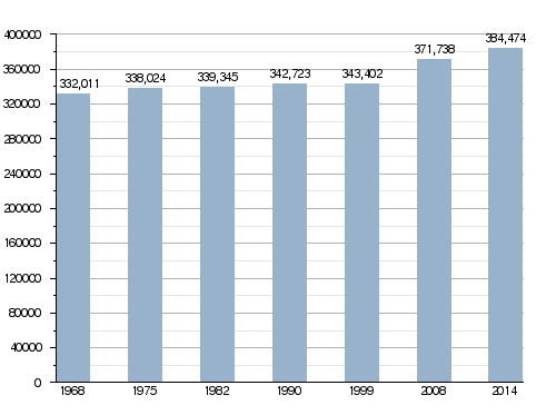
| • Total | 384,474 | ||
| • Density | 66.7733/km2 (172.9421/sq mi) | ||
| Demonym(s) | Tarnais | ||
| Time zone | UTC+1 (CET) | ||
| • Summer (DST) | UTC+2 (CEST) | ||
| ISO 3166 code | FR-81 | ||
| Arrondissements | 2 | ||
| Cantons | 23 | ||
| Communes | 320 | ||
| Website | http://www.tarn.fr | ||


Tarn (Occitan: Tarn) is a special area in France, located in the southwest. It's called a "department," which is like a big county. Tarn gets its name from the Tarn River that flows through it. The biggest city and main office for the department is Albi.
Contents
History of Tarn
Tarn is one of the first 83 departments ever created in France. This happened during the French Revolution on March 4, 1790. It was formed from a part of an older region called Languedoc.
The new department first had five smaller areas called districts. These were Albi, Castres, Lavaur, Gaillac, and Lacaune. The main city, or "capital," changed a few times. At first, it was Albi, then it moved to Castres in 1797. But in 1800, Albi became the capital again and has been ever since.
Geography of Tarn

Tarn is part of the Occitanie region in France. It covers an area of about 5,758 square kilometers (2,223 square miles).
The department shares its borders with five other departments, all within the Occitanie region:
- Hérault to the southeast
- Aude to the south
- Aveyron to the north and east
- Haute-Garonne to the southwest and west
- Tarn-et-Garonne to the northwest
 |
Tarn-et-Garonne | Aveyron | |
|
| Haute-Garonne | Aveyron | |||
| Haute-Garonne | Aude | Hérault |
The central part of Tarn has many hills. However, the valley of the Tarn River is mostly flat. The department also has two main mountain ranges. These are the Monts de Lacaune in the southeast and the Montagne Noire in the south.
Mountains and Rivers
The Monts de Lacaune are mountains located near the town of Lacaune. The highest point in Tarn is Puech de Rascas, which is part of this range. It stands at 1,270 meters (4,167 feet) above sea level.
The Montagne Noire (which means "Black Mountain") is another mountain range. It's in the southern part of France, at the edge of the Massif Central. Its highest point is the Pic de Nore, reaching 1,211 meters (3,973 feet) high. This mountain is inside the Haut-Languedoc Regional Natural Parc, a protected natural area.
The most important river in the department is the Tarn River. Another important river is the Agout river, which flows into the Tarn.
Climate in Tarn
The climate in Albi, the main city, is like an oceanic climate. This means it has mild summers.
On average, Albi gets about 1,023.6 millimeters (40.3 inches) of rain each year. November is usually the wettest month, while July is the driest.
The average temperature in Albi for the whole year is 13.4°C (56.1°F). July is the warmest month, with an average of 22.3°C (72.1°F). January is the coolest month, with an average of 5.4°C (41.7°F).
Administration of Tarn
The department of Tarn is managed by the Departmental Council of the Tarn. This council is based in Albi. Tarn is part of the larger Occitanie region.
Administrative Divisions
Tarn is divided into smaller areas to help with its administration.
- There are 2 main arrondissements (which are like large districts).
- There are 23 cantons (smaller administrative areas).
- There are 320 communes (which are like towns or municipalities).
The two arrondissements are:
| INSEE code |
Arrondissement | Capital | Population (2014) |
Area (km²) |
Density (Inh./km²) |
Communes |
|---|---|---|---|---|---|---|
| 811 | Albi | Albi | 190,101 | 2,731.7 | 69.6 | 169 |
| 812 | Castres | Castres | 194,373 | 3,026.2 | 64.2 | 151 |
Here is a list of the 23 cantons in Tarn, which were reorganized in March 2015:
- Albi-1 (8101)
- Albi-2 (8102)
- Albi-3 (8103)
- Albi-4 (8104)
- Carmaux-1 Le Ségala (8105)
- Carmaux-2 Vallée du Cérou (8106)
- Castres-1 (8107)
- Castres-2 (8108)
- Castres-3 (8109)
- Les Deux Rives (8110)
- Gaillac (8111)
- Graulhet (8112)
- Le Haut Dadou (8113)
- Les Hautes Terres d'Oc (8114)
- Lavaur Cocagne (8115)
- Mazamet-1 (8116)
- Mazamet-2 Vallée du Thoré (8117)
- La Montagne noire (8118)
- Le Pastel (8119)
- Plaine de l'Agoût (8120)
- Les Portes du Tarn (8121)
- Saint-Juéry (8122)
- Vignobles et Bastides (8123)
Population of Tarn
The people who live in Tarn are called Tarnais (for men) or Tarnaises (for women) in French.
In 2014, Tarn had a population of 384,474 people. This means there were about 67 people living in each square kilometer. The arrondissement of Castres had more people (194,373) than the arrondissement of Albi (190,101).
The city with the most people is Albi, the capital, with 49,531 residents. The city of Castres is next, with 41,382 residents.
How the population of Tarn has changed over time
Here are the cities in Tarn with more than 6,000 people:

| City | Population (2014) |
Arrondissement |
|---|---|---|
| Albi | 49,531 | Albi |
| Castres | 41,382 | Castres |
| Gaillac | 15,077 | Albi |
| Graulhet | 12,063 | Castres |
| Lavaur | 10,592 | Castres |
| Mazamet | 10,173 | Castres |
| Carmaux | 9,542 | Albi |
| Saint-Sulpice-la-Pointe | 8,642 | Castres |
| Saint-Juéry | 6,792 | Albi |
| Labruguière | 6,478 | Castres |
| Aussillon | 6,121 | Castres |
Images for kids
-
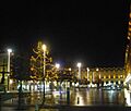
Jean Jaurès square, Castres, at night
-
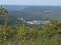
The town of Penne seen from the Grésigne forest
-
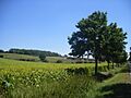
Sunflowers near Salvagnac


_Gresigne.jpg)

Related Pages
See also
 In Spanish: Tarn para niños
