
Aveyron facts for kids
Quick facts for kids
Aveyron
|
|||
|---|---|---|---|

|
|||
|
|||

Location of Aveyron in France
|
|||
| Country | France | ||
| Region | Occitanie | ||
| Département | 4 March 1790 | ||
| Prefecture | Rodez | ||
| Subprefectures | Millau, Villefranche-de-Rouergue | ||
| Area | |||
| • Total | 8,735.1 km2 (3,372.6 sq mi) | ||
| Population
(2014)
|
|||
| • Total | 278,644 | ||
| • Rank | 78th | ||
| • Density | 31.89935/km2 (82.6189/sq mi) | ||
| Demonym(s) | Aveyronnais | ||
| Time zone | UTC+1 (CET) | ||
| • Summer (DST) | UTC+2 (CEST) | ||
| ISO 3166 code | FR-12 | ||
| Arrondissements | 3 | ||
| Cantons | 23 | ||
| Communes | 286 | ||
| Website | http://aveyron.fr/ | ||


Aveyron (Occitan: Avairon) is a French department found in the northeast of the Occitanie region of southern France. It is named after the Aveyron River. The main city and capital of the department is Rodez.
Contents
History of Aveyron
Aveyron was created on March 4, 1790, during the French Revolution. It was one of the first 83 departments in France. Most of its land came from an old province called Rouergue. In fact, the flag of Aveyron today is the same as the old flag of Rouergue.
Ancient Inhabitants and Dolmens
Before written history, people lived in this area. The first known historical group was the Rutenii tribe. But even before them, people built many amazing structures. Aveyron has over 1,000 dolmens, which are ancient stone tombs or monuments. This is more than any other department in France!
Changes Over Time
In 1808, a small part of Aveyron, the area of Saint-Antonin-Noble-Val, was moved to a new department called Tarn-et-Garonne.
Geography of Aveyron

Aveyron is located in the Occitanie region in southern France. It is the 6th largest department in France, covering about 8,735 square kilometers (3,373 square miles).
Neighboring Departments
Aveyron shares its borders with seven other departments:
- In the north: Cantal (part of the Auvergne-Rhône-Alpes region)
- In the east: Lozère (part of Occitanie)
- In the southeast: Gard and Hérault (both part of Occitanie)
- In the south: Tarn (part of Occitanie)
- In the west: Tarn-et-Garonne and Lot (both part of Occitanie)
 |
Lot | Cantal | |
|
| Tarn-et-Garonne | Lozère | |||
| Tarn | Gard Hérault |
Landscape and Rivers
Aveyron is in the southern part of France's central plateau, known as the Massif Central. About one-third of the department is mountainous, with areas like the Aubrac mountains and Lacaune. The highest point is Signal de Mailhe-Biau, which is 1,463 meters (4,800 feet) high. The other two-thirds of Aveyron are made up of hills and plateaus, with some river valleys.
Important rivers like the Lot and Tarn flow through Aveyron. These rivers are tributaries of the larger Garonne river. The Aveyron River, which gives the department its name, is a tributary of the Tarn River. These rivers generally flow from east to west, dividing the department into four main areas.
Climate in Aveyron
Aveyron has a climate known as a Mediterranean Climate (Csb in the Köppen climate classification). This means it has dry summers.
In the city of Millau, the average temperature for the whole year is about 10.9°C (51.6°F). July is usually the warmest month, with an average temperature of 19.9°C (67.8°F). January is the coolest, averaging 3.2°C (37.8°F).
Millau gets about 731.5 millimeters (28.8 inches) of rain each year. September is the wettest month, with about 78.7 millimeters (3.1 inches) of rain. July is the driest month, with only about 40.6 millimeters (1.6 inches) of rain on average.
Administration of Aveyron
Aveyron is part of the Occitanie region. The department is run by the Departmental Council of the Aveyron, which is located in Rodez.
Administrative Divisions Explained
France is divided into smaller areas to help with local government. Aveyron has:
- 3 arrondissements (these are like large districts)
- 23 cantons (smaller areas within arrondissements)
- 286 communes (these are like towns or municipalities)
| INSEE code |
Arrondissement | Capital | Population (2014) |
Area (km²) |
Density (Inh./km²) |
Communes |
|---|---|---|---|---|---|---|
| 121 | Millau | Millau | 70,995 | 3,467.3 | 20.5 | 97 |
| 122 | Rodez | Rodez | 143,841 | 3,974.4 | 36.2 | 127 |
| 123 | Villefranche-de-Rouergue | Villefranche-de-Rouergue | 63,808 | 1,293.4 | 49.3 | 62 |
-
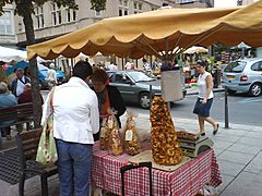
Rodez market
-
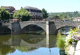
Pont des Consuls, Villefranche-de-Rouergue


The 23 cantons of the Aveyron department are listed below. These were reorganized in March 2015:
- Aubrac et Carladez (1201)
- Aveyron et Tarn (1202)
- Causse-Comtal (1203)
- Causses-Rougiers (1204)
- Ceor-Ségala (1205)
- Enne et Alzou (1206)
- Lot et Dourdou (1207)
- Lot et Montbazinois (1208)
- Lot et Palanges (1209)
- Lot et Truyère (1210)
- Millau-1 (1211)
- Millau-2 (1212)
- Monts du Réquistanais (1213)
- Nord-Lévezou (1214)
- Raspes et Lévezou (1215)
- Rodez-1 (1216)
- Rodez-2 (1217)
- Rodez-Onet (1218)
- Saint-Affrique (1219)
- Tarn et Causses (1220)
- Vallon (1221)
- Villefranche-de-Rouergue (1222)
- Villeneuvois et Villefranchois (1223)
Population of Aveyron
The people who live in Aveyron are called Aveyronnais (for men) or Aveyronnaises (for women) in French.
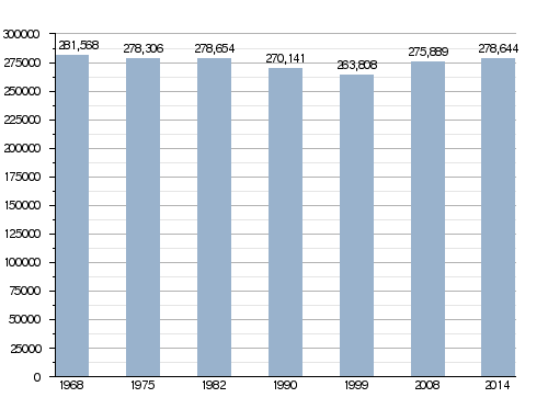
In 2014, Aveyron had a population of 278,644 people. This means there were about 31.9 inhabitants per square kilometer (82.6 per square mile). The arrondissement of Rodez is the largest, with 143,841 people. Millau has 70,995 people, and Villefranche-de-Rouergue has 63,808 people.
The capital city, Rodez, is the most populated city with 24,088 residents. The subprefectures of Millau and Villefranche-de-Rouergue have 22,064 and 11,822 residents, respectively.
Evolution of the population in Aude

The 10 most important cities in the department by population are:
| City | Population (2014) |
Arrondissement |
|---|---|---|
| Rodez | 24,088 | Rodez |
| Millau | 22,064 | Millau |
| Onet-le-Château | 11,837 | Rodez |
| Villefranche-de-Rouergue | 11,822 | Villefranche-de-Rouergue |
| Saint-Affrique | 8,260 | Millau |
| Luc-la-Primaube | 5,898 | Rodez |
| Decazeville | 5,686 | Villefranche-de-Rouergue |
| Capdenac-Gare | 4,558 | Villefranche-de-Rouergue |
| Espalion | 4,460 | Rodez |
| Sévérac d'Aveyron | 4,134 | Millau |
Related pages
Images for kids
-
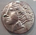
Ruteni coin, 5th–1st century BCE
-
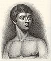
Victor of Aveyron in 1800
-
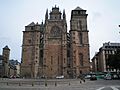
Rodez Cathedral
-
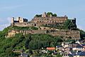
Sévérac-le-Château
-
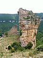
Château de Peyrelade
-
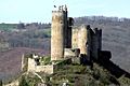
Château de Najac
-
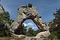
Chaos de Montpellier-le-Vieux


See also
 In Spanish: Aveyron para niños
