
Rodez facts for kids
Quick facts for kids
Rodez
|
|
|---|---|

City view.
|
|
| Country | France |
| Region | Occitanie |
| Department | Aveyron |
| Arrondissement | Rodez |
| Canton | Chief town of 3 cantons |
| Intercommunality | Grand Rodez |
| Area
1
|
11.18 km2 (4.32 sq mi) |
| Population
(2013)
|
23,741 |
| • Density | 2,123.5/km2 (5,499.9/sq mi) |
| Time zone | UTC+01:00 (CET) |
| • Summer (DST) | UTC+02:00 (CEST) |
| INSEE/Postal code |
12202 /12000
|
| Elevation | 501–643 m (1,644–2,110 ft) (avg. 572 m or 1,877 ft) |
| 1 French Land Register data, which excludes lakes, ponds, glaciers > 1 km2 (0.386 sq mi or 247 acres) and river estuaries. | |
Rodez (which is called Rodés in the local Occitan language) is a city in southwestern France. It is the main city, or prefecture, of the Aveyron area.
Rodez used to be the main city of a old French region called Rouergue. Today, it is also the main city for three smaller areas called cantons: Rodez-1, Rodez-2, and Rodez-Onet.
Contents
History of Rodez
Rodez is a very old city! It has been around since at least the 5th century BC. It was first built by a group of Celtic people called the Ruteni.
They built a strong, fortified place here, which was like a hill fort, called an oppidum. When the Romans took over, they named it Segodunum, which means "Fortified place" or "high hill." Later, the town was called Civitas Rutenorum (City of the Ruteni), then just Ruteni, and finally, Rodez.
After the Western Roman Empire fell, different groups took control of the city. First, the Visigoths ruled, then the Franks. In 725 AD, the Moors took the city and destroyed an old church. Later, armies from the Dukes of Aquitaine and the Counts of Toulouse occupied Rodez. During the Hundred Years' War, English soldiers also took over the city for a time.
In 1790, when the Aveyron area was created, Rodez became its prefecture, which means it became the administrative center.
Geography and Climate
Rodez is located in the western part of the Massif Central, which is a large area of mountains and plateaus in central France. The Aveyron River and a small stream called the Auterne flow through the city.
The city of Rodez covers an area of about 11.18 square kilometers (4.32 square miles). Its average height above sea level is 572 meters (1,877 feet). At the city hall, the height is 627 meters (2,057 feet).
 |
Rodez is surrounded by other towns. These include Onet-le-Château, Sainte-Radegonde, Le Monastère, and Olemps.
 |
Onet-le-Château | Onet-le-Château | Onet-le-Château | |
| Olemps | Sainte-Radegonde | |||
| Olemps | Le Monastère | Le Monastère |
Rodez Climate
Rodez has an oceanic climate with mild summers. This type of climate is known as Cfb in the Köppen climate classification system. This means it usually has cool winters and warm, but not too hot, summers.
Population of Rodez
In 2012, Rodez had a population of 23,741 people. This means that about 2,124 people live in each square kilometer of the city. This is called the population density.
The people who live in Rodez are called Ruthénois (for men) and Ruthénoises (for women) in French.
Sister Cities
Rodez has special friendships with other cities around the world. These are called "sister cities" or "twin towns."
 Pigüé, Buenos Aires Province, Argentina
 Bamberg, Bavaria, Germany
 Fderîck, Mauritania
Related pages
Arrondissements of the Aveyron department
Images for kids
-

Rodez-Aveyron has a daily connection to Paris-Orly in 1 hour 25 minutes.
-
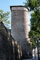
Tour des Corbières, a tower from the 15th century, with a part of the old city walls.
-
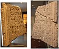
A Latin inscription found in Rodez from the time of Emperor Augustus.
-
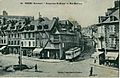
The city center in the early 1900s. It was connected to the train station by a tramway.
-
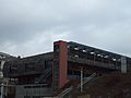
The Dojo gym.
-
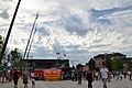
Estivada 2015, a festival celebrating Occitan culture.
-
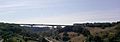
The Viaduct de l'Europe, a bridge connecting the city center to the Bourran Quarter.
-
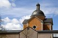
The Paraire Chapel in Rodez.
-
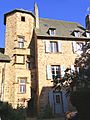
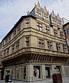
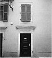
Hôtel de Bonald, a historic building.
-
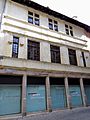
Maison d'Armagnac, another historic house.
-
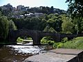
Layoule Bridge.
-
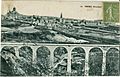
The Gascarie Viaduct, around 1910.
-
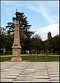
Foirail public garden.
-
Society of letters of Aveyron.
-
Fenaille museum, located in the Hotel Jouéry.
.jpg)


.jpg)


See also
 In Spanish: Rodez para niños
