
Aveyron (river) facts for kids
Quick facts for kids Aveyron |
|
| Occitan: Avairon | |
| River | |
_pont.jpg) 15th-century bridge at Belcastel, Aveyron
|
|
| Country | France |
|---|---|
| Region | Occitanie |
| Departments | Aveyron, Tarn, Tarn-et-Garonne |
| Communes | Sévérac-le-Château, Laissac, Rodez, Villefranche-de-Rouergue, Najac, Penne, Saint-Antonin-Noble-Val, Bruniquel, Montricoux, Nègrepelisse, Piquecos |
| Tributaries | |
| - left | Viaur, Cérou, Vère, Serène |
| - right | Alzou, Bonnette, Lère, Serre |
| Cities | Rodez, Villefranche-de-Rouergue |
| Source | Causse de Sévérac |
| - location | Sévérac-le-Château, Massif Central, France |
| - elevation | 735 m (2,411 ft) |
| - coordinates | 44°18′46″N 3°05′38″E / 44.31278°N 3.09389°E |
| Confluence | Tarn |
| - location | Piquecos, Tarn-et-Garonne, France |
| - elevation | 71 m (233 ft) |
| - coordinates | 44°05′15″N 1°15′58″E / 44.08750°N 1.26611°E |
| Length | 290.9 km (181 mi) |
| Basin | 5,170 km² (1,996 sq mi) |
| Discharge | for Piquecos |
| - average | 53.10 m³/s (1,875 cu ft/s) |
The Aveyron (which is called Avairon in Occitan) is a river in southern France. It flows into the Tarn River. The Aveyron department, a part of France, gets its name from this river.
Contents
Aveyron River Facts
The Aveyron River is about 291 kilometers (181 miles) long. It has a drainage basin of about 5,170 square kilometers (1,996 square miles). A drainage basin is the area of land where all the water flows into one river.
Water Flow of the Aveyron
Scientists have measured how much water flows in the Aveyron River from 1914 to 2017. This measurement is called the discharge. It tells us the volume of water that passes a certain point in the river each second.
The measurements were taken near Piquecos, a small town in the Tarn-et-Garonne department. This spot is close to where the Aveyron joins the Tarn River. On average, about 53.10 cubic meters (1,875 cubic feet) of water flow past this point every second.
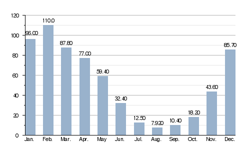
Average monthly discharge (m3/s) at Piquecos
This chart shows how the river's water flow changes throughout the year. As you can see, it has the most water in February and the least in August.
Where the Aveyron Flows
The source of the Aveyron River is in the southern part of the Massif Central mountains. It starts near the town (called a commune in France) of Sévérac-le-Château. The river begins at an altitude of about 735 meters (2,411 feet) above sea level.
The Aveyron River flows through several departments and towns in France:
- In the Aveyron department, it passes through:
- Sévérac-le-Château
- Laissac
- Rodez
- Villefranche-de-Rouergue
- Najac
- In the Tarn department, it passes through:
- Penne
- In the Tarn-et-Garonne department, it passes through:
- Saint-Antonin-Noble-Val
- Bruniquel
- Montricoux
- Nègrepelisse
- Piquecos
The Aveyron River flows through a total of 62 different communes (towns or local areas). Three of these communes are even named after the river: Agen-d'Aveyron, Gaillac-d'Aveyron, and Clairvaux-d'Aveyron.
Finally, the Aveyron River joins the Tarn River. This meeting point, called a confluence, is northwest of Montauban. It happens between the towns of Lafrançaise and Villemade in the Tarn-et-Garonne department. At this point, the river is about 71 meters (233 feet) above sea level.
Main Tributaries
A tributary is a smaller stream or river that flows into a larger river. The Aveyron River has several important tributaries:
|
Rivers joining from the left:
|
Rivers joining from the right:
|
Gallery
-
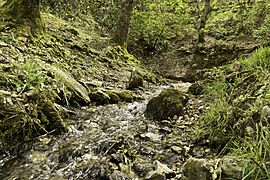
The source of the Aveyron River.
-
The Aveyron River in Najac.
-
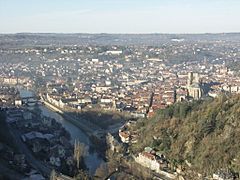
The Aveyron River in Villefranche-de-Rouergue.
-
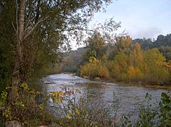
The Aveyron River near Piquecos.
-
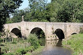
A bridge over the Aveyron River in Montrozier.


See also
 In Spanish: Río Aveyron para niños
