
Tarn-et-Garonne facts for kids
Quick facts for kids
Tarn-et-Garonne
|
|||
|---|---|---|---|
.jpg)
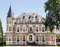
Prefecture building of the Tarn-et-Garonne department, in Montauban
|
|||
|
|||

Location of Tarn-et-Garonne in France
|
|||
| Country | France | ||
| Region | Occitanie | ||
| Département | 4 November 1808 | ||
| Prefecture | Montauban | ||
| Subprefecture | Castelsarrasin | ||
| Area | |||
| • Total | 3,718.3 km2 (1,435.6 sq mi) | ||
| Population
(2014)
|
|||
| • Total | 252,578 | ||
| • Density | 67.9284/km2 (175.9336/sq mi) | ||
| Demonym(s) | Tarn-et-Garonais | ||
| Time zone | UTC+1 (CET) | ||
| • Summer (DST) | UTC+2 (CEST) | ||
| ISO 3166 code | FR-82 | ||
| Arrondissements | 2 | ||
| Cantons | 15 | ||
| Communes | 195 | ||
| Website | Official website: http://www.ledepartement.fr/ | ||


Tarn-et-Garonne is a special area in the southwest of France. It is called a department. This department is part of the Occitanie region. It gets its name from two rivers: the Garonne river and its smaller river, the Tarn. The main city and capital of Tarn-et-Garonne is Montauban.
Contents
History of Tarn-et-Garonne
Tarn-et-Garonne is different from many other French departments. It was not created during the French Revolution in 1790. Instead, it was formed much later, on November 4, 1808. This happened during the time of the First French Empire, under the rule of Napoleon I.
The land for this new department came from several nearby areas. More than half of it was taken from the Lot department. This included important cities like Montauban and Moissac. A large part also came from Haute-Garonne, including Castelsarrasin. Smaller pieces were taken from the departments of Lot-et-Garonne, Gers, and Aveyron.
When it was first created, Tarn-et-Garonne had three main areas called arrondissements. These were Montauban, Castelsarrasin, and Moissac. Montauban was chosen as the capital. Later, on September 10, 1926, the arrondissement of Moissac was removed.
Geography of Tarn-et-Garonne

Tarn-et-Garonne is located in the Occitanie region. It covers an area of about 3,718 square kilometers (1,436 square miles).
The department shares its borders with six other departments:
- In the Occitanie region:
- Lot to the north
- Aveyron to the northeast
- Tarn to the east
- Haute-Garonne to the south
- Gers to the southwest
- In the Nouvelle-Aquitaine region:
- Lot-et-Garonne to the northwest
 |
Lot-et-Garonne | Lot | Aveyron | |
| Tarn | ||||
| Gers | Haute-Garonne |
The highest point in Tarn-et-Garonne is called Puech des Carts - Sommet Nord. It is 504 meters (1,654 feet) high. This peak is found in the town of Castanet.
Even though Tarn-et-Garonne is one of the smaller departments in France, it has many different types of landscapes. You can find flat plains between the Tarn and Garonne rivers. There are also rolling hills in the Lomagne region, which is in the southwest. In the north, you can see Causse areas. These are limestone plateaus.
The most important rivers in the department are the Garonne and its smaller rivers, the Tarn and Aveyron.
Climate in Tarn-et-Garonne
The climate in Montauban, the capital, is generally mild. It has warm summers and cool winters.
On average, Montauban gets about 708.7 millimeters (27.9 inches) of precipitation each year. October is usually the wettest month, with about 71.1 millimeters (2.8 inches) of rain. February is the driest month, with about 48.3 millimeters (1.9 inches) of rain.
The average yearly temperature in Montauban is 13.6°C (56.5°F). July is the warmest month, with an average temperature of 22.3°C (72.1°F). January is the coolest month, with an average temperature of 5.6°C (42.1°F).
Administration of Tarn-et-Garonne
Tarn-et-Garonne is governed by the Departmental Council of Tarn-et-Garonne. This council is located in Montauban. The department is part of the larger Occitanie region.
Administrative Divisions
Tarn-et-Garonne is divided into smaller areas to help with its administration. There are 2 main arrondissements (which are like districts). It also has 15 cantons and 195 communes (which are like towns or cities).
| Arrondissement | Capital | Population (2014) |
Area (km²) |
Communes |
|---|---|---|---|---|
| Castelsarrasin | Castelsarrasin | 76,822 | 1,601.5 | 103 |
| Montauban | Montauban | 175,756 | 2,116.8 | 92 |
Here is a list of the 15 cantons in Tarn-et-Garonne. These were updated in March 2015:
- Aveyron-Lère
- Beaumont-de-Lomagne
- Castelsarrasin
- Garonne-Lomagne-Brulhois
- Moissac
- Montauban-1
- Montauban-2
- Montauban-3
- Montech
- Pays de Serres Sud-Quercy
- Quercy-Aveyron
- Quercy-Rouergue
- Tarn-Tescou-Quercy vert
- Valence
- Verdun-sur-Garonne
Population of Tarn-et-Garonne
People who live in Tarn-et-Garonne are called Tarn-et-Garonnais in French. For women, the term is Tarn-et-Garonnaises.
As of 2014, Tarn-et-Garonne had a population of 252,578 people. This means there were about 68 people living in each square kilometer. The arrondissement of Montauban has the most people, with 175,756 residents. The arrondissement of Castelsarrasin has 76,822 residents.
The city with the largest population is the capital, Montauban, with 58,826 people. The town of Castelsarrasin has 13,765 people.
How the population of Tarn-et-Garonne has changed

Here are the cities in the department with more than 5,000 people:
| City | Population (2014) |
Arrondissement |
|---|---|---|
| Montauban | 58,826 | Montauban |
| Castelsarrasin | 13,765 | Castelsarrasin |
| Moissac | 12,408 | Castelsarrasin |
| Caussade | 6,805 | Montauban |
| Montech | 6,158 | Montauban |
| Nègrepelisse | 5,511 | Montauban |
| Valence | 5,194 | Castelsarrasin |
Gallery
-
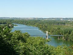
The Garonne river seen from Auvillar
-
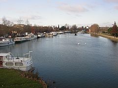
Port Jacques-Yves Cousteau, Castelsarrasin
-
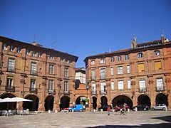
Montauban - Place National


Related pages
Images for kids
-
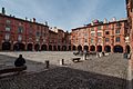
National square in Montauban
-
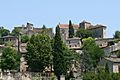
Bruniquel, one of the formally listed "Most Beautiful Villages of France"
-
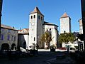
Saint Barthelemy church in Lauzerte
-
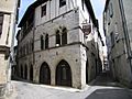
The "King's House" in Saint-Antonin-Noble-Val
-
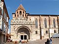
Saint Peter abbey in Moissac
-
Château de Montauriol, seat of the Departmental Council of Tarn-et-Garonne


.jpg)
See also
 In Spanish: Tarn y Garona para niños
