
Lot (department) facts for kids
Quick facts for kids
Lot
|
|||
|---|---|---|---|

Prefecture building of the Lot department, in Cahors
|
|||
|
|||

Location of Lot in France
|
|||
| Country | France | ||
| Region | Occitanie | ||
| Département | 4 March 1790 | ||
| Prefecture | Cahors | ||
| Subprefectures | Figeac, Gourdon | ||
| Area | |||
| • Total | 5,216.5 km2 (2,014.1 sq mi) | ||
| Population
(2014)
|
|||
| • Total | 173,648 | ||
| • Density | 33.2882/km2 (86.2161/sq mi) | ||
| Demonym(s) | Lotois | ||
| Time zone | UTC+1 (CET) | ||
| • Summer (DST) | UTC+2 (CEST) | ||
| ISO 3166 code | FR-46 | ||
| Arrondissements | 3 | ||
| Cantons | 17 | ||
| Communes | 326 | ||
| Website | http://www.lot.fr | ||


Lot (pronounced "Lo") is a special area in southern France. It's called a "department" and is part of the Occitanie region. The department gets its name from the Lot River that flows through it. The biggest city and main administrative center is Cahors.
Contents
History of the Lot Department
The Lot department was created a long time ago, on March 4, 1790. This happened during the French Revolution, when France was reorganizing its regions. Lot was formed from an older area called Quercy.
At first, the new department had six main districts. These were Cahors, Martel, Gourdon, Figeac, Montauban, and Lazorte. Cahors was chosen as the main city, or "capital" (now called the "prefecture").
Later, in 1808, some parts of the Lot department were taken to create a new department called Tarn-et-Garonne. This means Lot used to stretch much further south and included the city of Montauban.
Exploring the Geography of Lot
Lot is part of the Occitanie region in France. It covers an area of about 5,216.5 square kilometers (about 2,014 square miles).
Neighboring Departments
The Lot department shares its borders with six other departments. These departments are in three different regions:
- In the Nouvelle-Aquitaine region:
- In the Auvergne-Rhône-Alpes region:
- In the Occitanie region:
 |
Corrèze | Cantal | |
|
| Dordogne | ||||
| Lot-et-Garonne | Tarn-et-Garonne | Aveyron |
Rivers and Landscapes
The Lot River flows through the department from east to west. It makes many twists and turns, called "meanders." The Dordogne River also flows through the northern part of the department.
Lot has seven different natural areas, each with its own unique look:
- The Segala (northeast): This area is in the eastern part of Lot. It's part of the Massif Central mountain range. The highest point in the Lot department, at 783 meters (2,569 feet) high, is found here in Labastide-du-Haut-Mont.
- The Limargue (center east): This is a narrow strip of land between the Segala and the Causses of Quercy. It lies between the valleys of the Dordogne and Lot rivers. Around the city of Figeac, it's known as Terrefort.
- The Causses of Quercy: These are several limestone plateaus. The valleys of the Dordogne, Lot, and Aveyron rivers cut through them. From north to south, these plateaus include the Causse of Martel, the Causse of Gramat, and the Causse of Limogne.
- The Bouriane (west): This area is very green with lots of plants. It looks quite different from the drier plateaus of the Causses.
- The Quercy Blanc (south): This area has small white limestone plateaus. In the valleys, farmers grow cereals, plants for vegetable oils, melons, plums, and tobacco.
- The Valley of the Lot River (south): This valley is famous for its many vineyards (where grapes for wine are grown) and vegetable crops.
- The Valley of the Dordogne River (north): This valley is known for its walnut groves and green meadows.
Understanding the Climate
The climate in Gourdon, located in the north of the department, is an oceanic climate. This means it has relatively warm summers, mild winters, and plenty of rain.
On average, Gourdon gets about 856 millimeters (33.7 inches) of rain each year. May is usually the wettest month, while February is the driest. It rains about 168 days a year, with January having the most rainy days and July having the fewest.
The average temperature in Gourdon throughout the year is about 12.8°C (55°F). July is the warmest month, with an average temperature of 20.9°C (69.6°F). January is the coolest month, with an average temperature of 5.2°C (41.4°F).
How Lot is Governed
The Lot department is managed by the Departmental Council of the Lot. This council meets in Cahors. Lot is part of the larger Occitanie region.
Administrative Divisions
The Lot department is divided into smaller administrative areas to help manage it. There are:
- 3 arrondissements (which are like large districts)
- 17 cantons (smaller areas for elections)
- 326 communes (which are like towns or municipalities)
| INSEE code |
Arrondissement | Capital | Population (2014) |
Area (km²) |
Density (inh./km²) |
Communes |
|---|---|---|---|---|---|---|
| 461 | Cahors | Cahors | 76,216 | 2,179.3 | 35.0 | 129 |
| 462 | Figeac | Figeac | 54,060 | 1,550.3 | 34.9 | 116 |
| 463 | Gourdon | Gourdon | 43,372 | 1,486.9 | 29.2 | 81 |
Here is a list of the 17 cantons in the Lot department. This list changed in March 2015 as part of a reorganization in France:
- Cahors-1
- Cahors-2
- Cahors-3
- Causse et Bouriane
- Causse et Vallées
- Cère et Ségala
- Figeac-1
- Figeac-2
- Gourdon
- Gramat
- Lacapelle-Marival
- Luzech
- Marches du Sud-Quercy
- Martel
- Puy-l'Évêque
- Saint-Céré
- Souillac


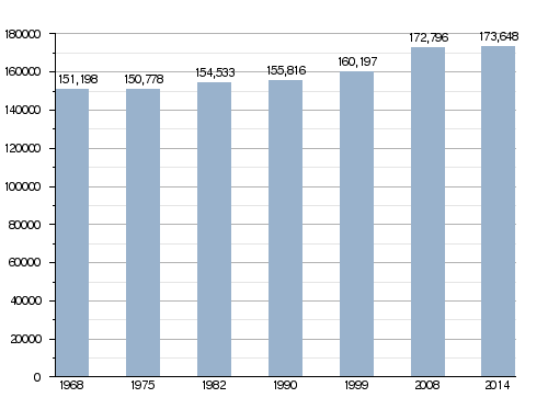
Population of Lot
The people who live in Lot are called Lotois (for men) or Lotoises (for women) in French.
In 2014, Lot had a population of 173,648 people. This means there were about 33.3 people living per square kilometer. The arrondissement of Cahors is the largest, with 76,216 people. Figeac has 54,060 people, and Gourdon has 43,372 people.
The city with the most people is the capital, Cahors, with 19,630 residents. The other main cities, Figeac and Gourdon, have 9,820 and 4,297 inhabitants, respectively.
How the population of Lot has changed over time
Here are the cities in the department with more than 2,000 people living in them:

| City | Population (2014) |
Arrondissement |
|---|---|---|
| Cahors | 19,630 | Cahors |
| Figeac | 9,820 | Figeac |
| Gourdon | 4,297 | Gourdon |
| Gramat | 3,611 | Gourdon |
| Saint-Céré | 3,503 | Figeac |
| Pradines | 3,433 | Cahors |
| Souillac | 3,366 | Gourdon |
| Prayssac | 2,499 | Cahors |
| Biars-sur-Cère | 2,033 | Figeac |
| Puy-l'Évêque | 2,020 | Cahors |
Gallery
-
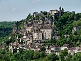
Rocamadour
-
The Lot river


Related Pages
Images for kids
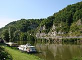
-
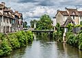
Lot River, after which the department is named
-
Saint-Céré
-
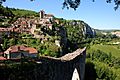
Saint-Cirq-Lapopie
-
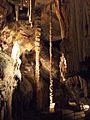
Grottes de Presque


See also
 In Spanish: Lot (departamento) para niños
