Célé facts for kids
Quick facts for kids Célé |
|
| River | |
|
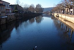
The Célé in Figeac
|
|
| Country | France |
|---|---|
| Regions | Auvergne-Rhône-Alpes, Occitanie |
| Departments | Cantal, Lot |
| Communes | See list |
| Tributaries | |
| - right | Ressègue, Rance, Veyre, Bervezou, Drauzou, Sagne |
| City | Figeac |
| Source | Massif Central |
| - location | Calvinet, Cantal, France |
| - elevation | 713 m (2,339 ft) |
| - coordinates | 44°28′28″N 1°38′54″E / 44.47444°N 1.64833°E |
| Mouth | Lot river |
| - location | Bouziès, Lot, France |
| - elevation | 125 m (410 ft) |
| - coordinates | 44°28′28″N 1°38′54″E / 44.47444°N 1.64833°E |
| Length | 104.4 km (65 mi) |
| Basin | 1,289 km² (498 sq mi) |
| Discharge | for Orniac |
| - average | 18.9 m³/s (667 cu ft/s) |
The Célé is a beautiful river located in southern France. It's like a smaller river that flows into a bigger one, called the Lot river. The Célé is the second biggest "helper" river for the Lot.
You'll find some towns that even have the river's name in them! These include Bagnac-sur-Célé, Marcilhac-sur-Célé, and Sauliac-sur-Célé.
Contents
About the Célé River
The Célé river is about 104.4 km (64.9 mi) long. That's like driving for over an hour! The area of land that collects water for the Célé is called its drainage basin. This area is about 1,289 km2 (498 sq mi).
The river's average flow, which is how much water moves past a certain point each second, is about 17.90 cubic metres per second near a town called Orniac. Imagine a big truckload of water passing by every second!
Where the Célé Starts and Ends
The Célé river begins high up in the Massif Central mountains. This is in a small town called Calvinet, in the Cantal area of France. It starts at an altitude of about 713 m (2,339 ft). That's pretty high up!
As it flows, the Célé generally moves towards the west. It travels through two main regions of France. It also passes through two different departments and 26 different towns, which are called communes in France.
Here are some of the places the Célé river flows through:
- In the Auvergne-Rhône-Alpes region:
- In the Cantal department: Calvinet, Saint-Constant, Maurs, Le Trioulou, Mourjou, Fournoulès, Cassaniouze.
- In the Occitanie region:
Finally, the Célé river joins the bigger Lot river. This happens in a town called Bouziès, also in the Lot department. At this point, the river is at an altitude of about 125 m (410 ft).
Main Rivers Joining the Célé
Rivers that flow into a bigger river are called tributaries. The Célé river has several important tributaries that join it from the right side. The smaller streams that join from the left side are not as big.
Here are the main right tributaries of the Célé river:
- Ressègue - This river is 22.4 kilometers long.
- Rance - This river is 35.9 kilometers long.
- Veyre - This river is 32.9 kilometers long.
- Bervezou - This river is 24 kilometers long.
- Drauzou - This river is 22.6 kilometers long.
More About Rivers
 | Aaron Henry |
 | T. R. M. Howard |
 | Jesse Jackson |


