
Tarn (river) facts for kids
Quick facts for kids Tarn |
|
| River | |
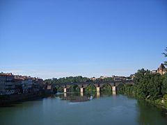
 The Tarn river at Albi
|
|
| Country | France |
|---|---|
| Region | Occitanie |
| Departments | Lozère, Aveyron, Tarn, Haute-Garonne, Tarn-et-Garonne |
| Communes | Le Pont-de-Montvert, Millau, Albi, Gaillac, Villemur-sur-Tarn, Montauban, Moissac |
| Tributaries | |
| - left | Tarnon, Jonte, Dourbie, Cernon, Dourdou de Camarès, Rance, Agout |
| - right | Muze, Alrance, Tescou, Aveyron, Lemboulas |
| Cities | Millau, Albi, Montauban, Saint-Juéry, Gaillac, Moissac |
| Source | Cévennes |
| - location | Mont Lozère, Massif Central, France |
| - elevation | 1,560 m (5,118 ft) |
| - coordinates | 44°24′54″N 3°48′51″E / 44.41500°N 3.81417°E |
| Mouth | Garonne |
| - location | Moissac, Tarn-et-Garonne, France |
| - elevation | 65 m (213 ft) |
| - coordinates | 44°05′11″N 3°48′51″E / 44.08639°N 3.81417°E |
| Length | 381 km (237 mi) |
| Basin | 15,700 km² (6,062 sq mi) |
| Discharge | for Moissac |
| - average | 233 m³/s (8,228 cu ft/s) |
The Tarn is a river located in southern France. It flows into the Garonne river, making it a "tributary" (a smaller river that joins a larger one). Two areas in France, the Tarn and Tarn-et-Garonne "departments" (like states or provinces), are named after this important river.
Contents
Tarn River Geography
The Tarn river is about 380.6 km (236.5 mi) long. Its "drainage basin" (the area of land where all the water flows into this river) covers about 15,700 km2 (6,062 sq mi).
Water Flow and Discharge
The average amount of water flowing in the Tarn river is called its "discharge". This is measured at Moissac, where the Tarn meets the Garonne. Over 57 years, the average discharge has been 233 m3/s (8,200 cu ft/s). This means 233 cubic meters of water pass by every second.
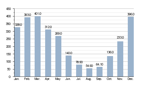
Average monthly discharge (m3/s) at Moissac
This chart shows how much water flows in the Tarn each month. You can see that more water flows in winter and spring. Less water flows in the summer months.
The Tarn's Journey: From Source to Mouth
The Tarn river begins high up on Mont Lozère. This mountain is part of the Cévennes mountains in the southeastern Massif Central region of France. The river's "source" (where it starts) is near the town of Le Pont-de-Montvert, in the Lozère department. It begins at a high "altitude" (height above sea level) of about 1,560 m (5,118 ft).
The Tarn generally flows towards the southwest. It passes through several regions and departments in France, including:
- Occitanie region
- Lozère: Le Pont-de-Montvert, Sainte-Enimie
- Aveyron: Millau, Saint-Rome-de-Tarn
- Tarn: Albi, Gaillac, Lisle-sur-Tarn, Rabastens, Saint-Sulpice-la-Pointe
- Haute-Garonne: Bessières, Buzet-sur-Tarn, Villemur-sur-Tarn
- Tarn-et-Garonne: Montauban, Lafrançaise, Moissac
The river flows through 104 different towns or "communes" (small administrative areas) in total.
Finally, the Tarn river joins the Garonne near Moissac. This meeting point is called a "confluence". The Tarn joins the Garonne as a "right tributary", meaning it flows into the Garonne from the right side. This happens at an altitude of about 23 m (75 ft).
Main Tributaries of the Tarn

A "tributary" is a stream or river that flows into a larger stream or river. The Tarn river has many tributaries. Here are some of the main ones that are longer than 25 kilometers:
|
Tributaries joining from the left: |
Tributaries joining from the right:
|
Gallery
-
The Tarn near Cocurès, Lozère
-
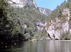
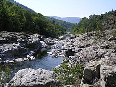
The Gorges of the Tarn river
-
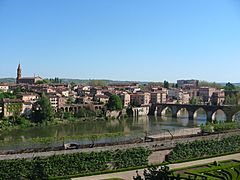
The Tarn at Albi
-
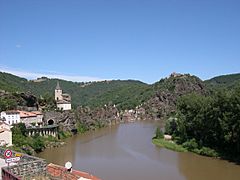
The Tarn at Ambialet
-
Pont Vieux, Montauban
.jpg)


Related pages
Images for kids
-
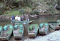
A boatman with some tourists begins a ride through the Gorges du Tarn
-
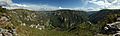
Tarn gorge, seen from the point sublime

See also
 In Spanish: Río Tarn para niños
