Arrondissement of Villefranche-de-Rouergue facts for kids
Quick facts for kids
Arrondissement of Villefranche-de-Rouergue
|
|
|---|---|

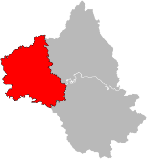
Location of Villefranche-de-Rouergue in Aveyron
|
|
| Country | France |
| Region | Occitanie |
| Department | Aveyron |
| Communes | 62 |
| Subprefecture | Villefranche-de-Rouergue |
| INSEE code | 123 |
| Area | |
| • Total | 1,293.4 km2 (499.4 sq mi) |
| Population
(2014)
|
|
| • Total | 63,808 |
| • Density | 49.3335/km2 (127.773/sq mi) |
The arrondissement of Villefranche-de-Rouergue is a special kind of administrative area in France. Think of it like a district within a larger region. It is part of the Aveyron department, which is located in the Occitanie region of France. The main town and administrative center of this arrondissement is the city of Villefranche-de-Rouergue.
Contents
History of Villefranche-de-Rouergue
When Arrondissements Were Created
The system of "arrondissements" was first set up in France a long time ago, on February 17, 1800. When this happened, Villefranche-de-Rouergue was chosen to be one of these new administrative areas in the Aveyron department.
Geography of Villefranche-de-Rouergue
Where is Villefranche-de-Rouergue Located?
The arrondissement of Villefranche-de-Rouergue is found in the western part of the Aveyron department. It is the smallest arrondissement in Aveyron when it comes to land size. Its total area is about 1,293.4 square kilometers (about 499 square miles).
Population and Neighbors
Even though it's the smallest in area, it also has the fewest people living there compared to other arrondissements in the department. In 2014, about 63,808 people lived here. This means it has a population density of about 49.3 people per square kilometer.
The arrondissement shares its borders with several other areas:
- To the north, it touches the Cantal department.
- To the east, it borders the Rodez arrondissement.
- To the south, it is next to the Tarn department.
- To the west, it meets the Tarn-et-Garonne and Lot departments.
How Villefranche-de-Rouergue is Organized
Understanding Cantons
In France, "cantons" are like smaller groups of towns. After a change in how cantons are organized, they are no longer just parts of one arrondissement. This means a canton can include towns that belong to different arrondissements.
In the Villefranche-de-Rouergue arrondissement, there are three cantons that have towns spread across different arrondissements. These are:
- Aveyron et Tarn
- Enne et Alzou
- Lot et Dourdou
Here's a simple look at how some cantons are divided:
| Canton | Towns in Rodez | Towns in Villefranche-de-Rouergue | Total Towns |
|---|---|---|---|
| Aveyron et Tarn | 5 | 12 | 17 |
| Enne et Alzou | 8 | 3 | 11 |
| Lot et Dourdou | 3 | 8 | 11 |
| Lot et Montbazinois | 16 | 16 | |
| Villefranche-de-Rouergue | 3 | 3 | |
| Villeneuvois et Villefranchois | 20 | 20 |
Main Towns (Communes) in the Arrondissement
The arrondissement of Villefranche-de-Rouergue has 62 "communes," which are like local towns or villages. Here are the towns with the most people living in them (based on 2014 data):
| Town Name | Population (2014) |
Main Canton |
|---|---|---|
| Villefranche-de-Rouergue | 11,822 | Villefranche-de-Rouergue |
| Decazeville | 5,686 | Lot et Dourdou |
| Capdenac-Gare | 4,558 | Lot et Montbazinois |
| Aubin | 3,888 | Enne et Alzou |
| Firmi | 2,441 | Enne et Alzou |
| Rieupeyroux | 2,001 | Aveyron et Tarn |
| Villeneuve | 1,954 | Villeneuvois et Villefranchois |
| Le Bas-Ségala | 1,615 | Aveyron et Tarn |
| Cransac | 1,541 | Enne et Alzou |
| Montbazens | 1,409 | Lot et Montbazinois |
Images for kids
Related pages
- Arrondissements of the Aveyron department
- Communes of the Aveyron department
- List of arrondissements of France
See also
 In Spanish: Distrito de Villefranche-de-Rouergue para niños
 | Bessie Coleman |
 | Spann Watson |
 | Jill E. Brown |
 | Sherman W. White |

