
Gard facts for kids
Quick facts for kids
Gard
|
|||
|---|---|---|---|

Prefecture building of the Gard department, in Nîmes
|
|||
|
|||

Location of Gard in France
|
|||
| Country | France | ||
| Region | Occitanie | ||
| Département | 4 March 1790 | ||
| Prefecture | Nîmes | ||
| Subprefectures | Alès, Le Vigan | ||
| Area | |||
| • Total | 5,852.8 km2 (2,259.8 sq mi) | ||
| Population
(2014)
|
|||
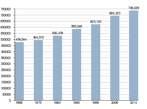
| • Total | 736,029 | ||
| • Rank | 33 | ||
| • Density | 125.7567/km2 (325.7084/sq mi) | ||
| Demonym(s) | Gardois | ||
| Time zone | UTC+1 (CET) | ||
| • Summer (DST) | UTC+2 (CEST) | ||
| ISO 3166 code | FR-30 | ||
| Arrondissements | 3 | ||
| Cantons | 23 | ||
| Communes | 353 | ||
| Website | http://www.gard.fr/ | ||


Gard is a French region in southern France. It is a "department," which is like a large county. Gard is part of the Occitanie region and is named after the Gardon river. The main city and administrative center of Gard is Nîmes.
Contents
History of Gard
Gard became one of France's 83 departments on March 4, 1790. This happened during the French Revolution, a big change in French history.
At first, Gard was divided into 8 smaller areas called "districts." These included Alais, Nîmes, and Uzès. Nîmes was chosen as the main city, sometimes sharing this role with Alais and Uzès. However, by 1794, Nîmes became the only capital city.
Later, these districts were reorganized into four "arrondissements." These were Nîmes, Alais, Uzès, and Le Vigan. In 1926, the Uzès arrondissement was removed, leaving three.
Geography and Landscape
Gard is located in the southern part of France, within the Occitanie region. It covers an area of about 5,853 square kilometers (2,259 square miles).
The department shares its borders with six other departments:
- To the south: Bouches-du-Rhône (in the Provence-Alpes-Côte d'Azur region)
- To the east: Vaucluse (in the Provence-Alpes-Côte d'Azur region)
- To the north: Ardèche (in the Auvergne-Rhône-Alpes region)
- To the southwest: Hérault (in the Occitanie region)
- To the west: Aveyron and Lozère (both in the Occitanie region)
Gard also has a coastline of about 23 kilometers (14 miles) along the Mediterranean Sea.
 |
Lozère | Ardèche | |
|
| Aveyron | Vaucluse | |||
| Hérault | Mediterranean Sea | Bouches-du-Rhône |
Natural Areas of Gard
Gard has four main natural areas, each with its own unique features:
- The Cévennes are a mountain chain that is part of the Massif Central. These mountains are found between the Lozère and Gard departments.
- The Garrigues is a natural area with hills and plateaus made of limestone. You can find this region in both the Hérault and Gard departments.
- The Costières is another natural region located south of Nîmes.
- The low region consists of flat plains. These plains are found along the Rhone river and near the coast.
The highest point in Gard is Mont Aigoual, which is 1,565 meters (5,135 feet) high. It is located in the Cévennes mountains, right on the border with the Lozère department.
The main river in Gard is the Gardon (also called Gard). It flows into the Rhone river. The Rhone river itself forms the eastern border of the department.
Climate in Gard
The climate in Gard, especially in the city of Nîmes, is a subtropical climate with dry summers. This is also known as a Mediterranean Climate.
The average yearly temperature in Nîmes is about 14.4°C (57.9°F). July is usually the warmest month, with an average temperature of 23.3°C (73.9°F). January is the coolest month, averaging 6.1°C (43.0°F).
Nîmes receives about 690.9 mm (27.2 inches) of rain each year. October is typically the wettest month, with about 106.7 mm (4.2 inches) of rain. July is the driest month, with only about 25.4 mm (1.0 inch) of rain on average.
How Gard is Governed
Gard is part of the Occitanie region. The department is managed by a group called the Departmental Council of the Gard, which is based in Nîmes.
Administrative Divisions
Gard is divided into smaller administrative areas to help manage it. There are:
- 3 arrondissements (which are like large districts)
- 23 cantons (smaller administrative areas)
- 353 communes (which are like towns or municipalities)
Here's a look at the arrondissements:
| INSEE code |
Arrondissement | Capital | Population (2014) |
Area (km²) |
Density (Inh./km²) |
Communes |
|---|---|---|---|---|---|---|
| 301 | Alès | Alès | 151,823 | 1,321.6 | 114.9 | 101 |
| 302 | Nîmes | Nîmes | 547,598 | 3,132.8 | 174.8 | 177 |
| 303 | Le Vigan | Le Vigan | 36,608 | 1,398.5 | 26.2 | 75 |
Here are the 23 cantons of the Gard department, as reorganized in March 2015:
- Aigues-Mortes (3001)
- Alès-1 (3002)
- Alès-2 (3003)
- Alès-3 (3004)
- Bagnols-sur-Cèze (3005)
- Beaucaire (3006)
- Calvisson (3007)
- La Grand-Combe (3008)
- Marguerittes (3009)
- Nîmes-1 (3010)
- Nîmes-2 (3011)
- Nîmes-3 (3012)
- Nîmes-4 (3013)
- Pont-Saint-Esprit (3014)
- Quissac (3015)
- Redessan (3016)
- Roquemaure (3017)
- Rousson (3018)
- Saint-Gilles (3019)
- Uzès (3020)
- Vauvert (3021)
- Le Vigan (3022)
- Villeneuve-lès-Avignon (3023)
Population of Gard
The people who live in Gard are called Gardois (for men) or Gardoises (for women) in French.
In 2014, Gard had a population of 736,029 people. This means there were about 126 people per square kilometer (326 people per square mile). The Nîmes arrondissement is the largest, with 547,598 people. Alès has 151,823 people, and Le Vigan has 36,608 people.
The biggest city in the department is its capital, Nîmes, with 151,075 residents. The subprefectures, Alès and Le Vigan, have populations of 39,993 and 3,933, respectively.
How the population of Gard has changed over time
Here are the 10 most populated cities in Gard:
| City | Population (2014) |
Arrondissement |
|---|---|---|
| Nîmes | 151,075 | Nîmes |
| Alès | 39,993 | Alès |
| Bagnols-sur-Cèze | 18,172 | Nîmes |
| Beaucaire | 15,859 | Nîmes |
| Saint-Gilles | 13,326 | Nîmes |
| Villeneuve-lès-Avignon | 11,716 | Nîmes |
| Vauvert | 11,353 | Nîmes |
| Pont-Saint-Esprit | 10,155 | Nîmes |
| Marguerittes | 8,577 | Nîmes |
| Uzès | 8,569 | Nîmes |
Gallery
-
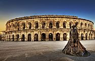
Arena of Nîmes, an ancient Roman amphitheater.
-
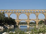
The Pont du Gard bridge, an old Roman aqueduct.
-
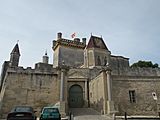
The historic Uzès castle.
-
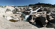
Sautadets Waterfalls on the Cèze river.


Related pages
Images for kids
-
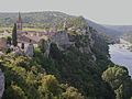
Aiguèze, a beautiful village in Gard.

See also
 In Spanish: Gard para niños
