
Gardon facts for kids
Quick facts for kids Gardon |
|
| Gard | |
| River | |
 The Gardon near the Pont du Gard
|
|
| Country | France |
|---|---|
| Region | Occitanie |
| Departments | Lozère, Gard |
| Main Communes | Saint-Jean-du-Gard, Anduze, Poulx, Remoulins |
| Tributaries | |
| - left | Gardon d'Alès, Droude, Dourbie, Bourdic, Alzon |
| - right | Gardon d'Anduze |
| Source | Cévennes |
| - location | Saint-Martin-de-Lansuscle, Lozère, France |
| - elevation | 1,050 m (3,445 ft) |
| - coordinates | 44°14′46″N 3°43′51″E / 44.24611°N 3.73083°E |
| Source confluence | with Gardon d'Alès |
| - location | between Cassagnoles and Vézénobres, Gard, France |
| - elevation | 92 m (302 ft) |
| - coordinates | 44°01′50″N 4°07′57″E / 44.03056°N 4.13250°E |
| Confluence | Rhône |
| - location | Comps, Gard, France |
| - elevation | 5 m (16 ft) |
| - coordinates | 43°50′32″N 4°37′16″E / 43.84222°N 4.62111°E |
| Length | 127.3 km (79 mi) |
| Basin | 1,999 km² (772 sq mi) |
| Discharge | for Sanilhac-Sagriès |
| - average | 32.7 m³/s (1,155 cu ft/s) |
| - max | 71.2 m³/s (2,514 cu ft/s) |
| - min | 4.53 m³/s (160 cu ft/s) |
The Gardon or Gard is a river in southeastern France. It flows through the Lozère and Gard departments in the Occitanie region. The Gardon is a branch, also called a tributary, of the larger Rhône river.
Did you know that the Gard department in France is actually named after this river?
Contents
About the Gardon River
The Gardon river is about 127.3 km (79.1 mi) long. The area of land that drains into the Gardon, called its drainage basin, covers about 1,999 km2 (772 sq mi).
Water Flow (Discharge)
The amount of water flowing in a river is called its discharge. The Gardon's average yearly discharge is about 32.7 m3/s (1,150 cu ft/s) near a place called Sanilhac-Sagriès in the Gard department. This means that, on average, 32.7 cubic meters of water pass by that point every second!

Average monthly discharge (m3/s) at Sanilhac-Sagriès
Where the Gardon Starts and Ends
The Gardon river actually begins as the Gardon d'Anduze. It starts high up in the Cévennes mountains, which are part of the Massif Central in southeastern France. Its source is near a place called Prat Reboubalès in the commune of Saint-Martin-de-Lansuscle, in the Lozère department. Here, the river is about 1,050 m (3,445 ft) above sea level.
The Gardon d'Anduze then meets another river called the Gardon d'Alès. This meeting point is between the towns of Cassagnoles and Vézénobres. From this point on, the river is usually just called the Gardon.
The Gardon generally flows towards the southeast. It travels through the Lozère and Gard departments in the Occitanie region. It passes through a total of 37 different towns or communes, most of them in the Gard department.
Finally, the Gardon river flows into the Rhône river. This happens near the town of Comps, at a low altitude of about 5 m (16 ft) above sea level. The Gardon is a "right tributary" of the Rhône, meaning it joins the Rhône from the right side if you are looking downstream.
Main Rivers Joining the Gardon
Several smaller rivers flow into the Gardon. These are called its tributaries. Here are some of the main ones that are longer than 20 kilometers:
- Le Gardon de Sainte-Croix - 27.9 km long
- Le Gardon de Saint-Jean - 49.4 km long
- Le Gardon d'Alès - 60.6 km long
- La Droude - 22.6 km long
- Le Bourdic - 25 km long
- L'Alzon - 23.7 km long
Gallery
-
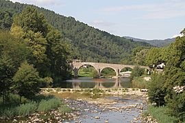
The Gardon river as seen from Saint-Jean-du-Gard
-
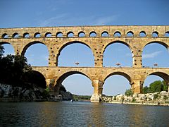
The famous Pont du Gard bridge built over the Gardon
-
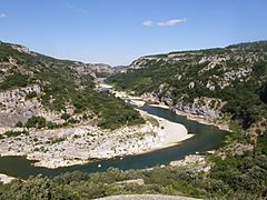
The amazing gorges of the Gardon, near Sanilhac-Sagriès
-
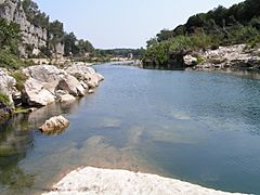
The Gardon river in Collias


Related pages
Images for kids
-
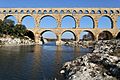
The ancient Roman Pont du Gard aqueduct
-
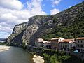
The Gardon river flowing through Anduze
-
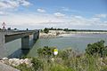
The Gardon river joining the Rhône river near Comps


See also
 In Spanish: Río Gardon para niños
