
Mont Aigoual facts for kids
Quick facts for kids Mont Aigoual |
|
|---|---|

East face of Mont Aigoua
|
|
| Highest point | |
| Elevation | 1,565 m (5,135 ft) |
| Prominence | 732 m (2,402 ft) |
| Geography | |
|
Lua error in Module:Location_map at line 420: attempt to index field 'wikibase' (a nil value).
|
|
| Location | Gard department, France |
| State/Province | FR |
| Parent range | Massif Central |
Mont Aigoual (which means Mount Augal in Occitan) is a French mountain located in the Cévennes area. This region is part of the southern Massif Central in the Occitanie region. The mountain sits right on the border between the Lozère and Gard departments. It is the highest mountain in the Gard department.
On a clear day, from the top of Mont Aigoual, you can see far away! You might spot the Mediterranean Sea, the Pyrenees mountains, and even the Alps, including the famous Mont Blanc.
Contents
What Does "Aigoual" Mean?
The name "Aigoual" has been used in different ways over time. In 1228, "Aigoaldi" referred to a route. By 1238, "Algoaldi" described the boundaries of a territory. Finally, in 1249, "Aigoaldi" became the name of the mountain itself. It is believed that the name "Aigoual" comes from "Algwarld," which was the name of a person who lived in the region long ago.
Exploring Mont Aigoual's Geography
Mont Aigoual stands tall at 1,565 m (5,135 ft) (about 5,135 feet). It is the highest mountain in the Gard department. It's also the second-highest in the Lozère department and in the Cévennes mountains. The highest peak in the Cévennes is Mont Lozère, which is 1,699 m (5,574 ft) (about 5,574 feet) high. Mont Aigoual is located inside the beautiful Cévennes National Park.
The very top of Mont Aigoual is a flat area called a plateau. This plateau is more than 1,500 m (4,900 ft) (about 4,921 feet) high and covers an area of about 2 km2 (0.77 sq mi) (about 0.77 square miles). This plateau is split by a watershed. This means that rain falling on one side flows towards the Atlantic Ocean, and rain on the other side flows towards the Mediterranean Sea.
On the southern side of the mountain, you can find the source of the Hérault river. This river flows south and eventually empties into the Mediterranean Sea. The mountain itself is made of a type of rock called granite. This granite formed a very long time ago, during the Palaeozoic era.
The Weather Station on Mont Aigoual
Right on top of Mont Aigoual, there is a special building: a meteorological station. It was built in 1887. This station is unique because it is the last remaining weather station in France where meteorologists still live and work. During the summer months, visitors can explore an exhibition about weather forecasting inside the station.
-
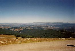
A view of the Cévennes from Lozére
-
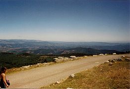
Looking towards the northeast from the mountain
-
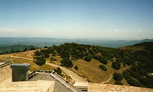
A view to the east, towards Vaucluse
-
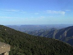
A view towards the sea


Understanding Mont Aigoual's Climate
Mont Aigoual has an oceanic climate (Cfc). This means it has cool summers and no dry season. It is also very close to a subarctic (Dfc) or highland climate, which means it can get quite cold.

| Climate data for Mont Aigoual, France (altitude 1565m, 1981–2010) (Source: Météo-France) | |||||||||||||
|---|---|---|---|---|---|---|---|---|---|---|---|---|---|
| Month | Jan | Feb | Mar | Apr | May | Jun | Jul | Aug | Sep | Oct | Nov | Dec | Year |
| Mean daily maximum °C (°F) | 1.0 (33.8) |
0.7 (33.3) |
3.0 (37.4) |
5.3 (41.5) |
9.7 (49.5) |
13.9 (57.0) |
17.3 (63.1) |
17.0 (62.6) |
13.0 (55.4) |
8.7 (47.7) |
4.2 (39.6) |
2.1 (35.8) |
8.0 (46.4) |
| Mean daily minimum °C (°F) | −3.5 (25.7) |
−3.8 (25.2) |
−2.0 (28.4) |
0.0 (32.0) |
4.1 (39.4) |
7.7 (45.9) |
10.4 (50.7) |
10.4 (50.7) |
7.2 (45.0) |
4.1 (39.4) |
−0.4 (31.3) |
−2.6 (27.3) |
2.6 (36.8) |
| Average precipitation mm (inches) | 175.4 (6.91) |
146.2 (5.76) |
109.3 (4.30) |
177.5 (6.99) |
159.7 (6.29) |
92.9 (3.66) |
48.3 (1.90) |
67.7 (2.67) |
175.4 (6.91) |
298.4 (11.75) |
282.0 (11.10) |
198.9 (7.83) |
1,931.7 (76.07) |
| Source: Météo France | |||||||||||||
Fun Activities and Sports
Mont Aigoual is a great place for outdoor activities!
Hiking Adventures
One very popular hiking trail is called the "Climbing of the 4,000 steps." This challenging route starts in a town called Valleraugue and finishes right at the weather station on top of the mountain. It's a long climb, but the views are amazing!
Skiing at Prat Peyrot
If you love winter sports, you'll be happy to know there's a ski station called Prat Peyrot on the sides of Mont Aigoual. A ski station is a place where people go to practice skiing and other snow sports. Prat Peyrot is the largest ski station in the Cévennes mountains, offering lots of fun for skiers and snowboarders.
