
Hérault (river) facts for kids
Quick facts for kids Hérault |
|
| River | |
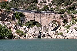
 Roman bridge of Saint-Thibéry across the Hérault
|
|
| Country | France |
|---|---|
| Region | Occitanie |
| Departments | Gard, Hérault |
| Communes | Valleraugue, Ganges, Pézenas, Agde |
| Tributaries | |
| - left | Rieutord |
| - right | Vis, Lergue, Peyne, Thongue |
| City | Agde |
| Source | Cévennes |
| - location | Mont Aigoual, Massif Central, France |
| - elevation | 1,370 m (4,495 ft) |
| - coordinates | 44°6′55″N 3°33′0″E / 44.11528°N 3.55000°E |
| Mouth | Mediterranean Sea |
| - location | Agde, Hérault, France |
| - elevation | 0 m (0 ft) |
| - coordinates | 43°16′57″N 3°26′38″E / 43.28250°N 3.44389°E |
| Length | 147.6 km (92 mi) |
| Basin | 2,582 km² (997 sq mi) |
| Discharge | for Agde |
| - average | 41.90 m³/s (1,480 cu ft/s) |
The Hérault (Occitan: Erau) is a river in southern France. It flows into the Mediterranean Sea. The Hérault department is named after this river.
Contents
About the Hérault River
The Hérault river is about 147.6 km (91.7 mi) long. Its drainage basin covers an area of 2,582 km2 (997 sq mi). A drainage basin is the land area where all the water drains into one river. About 64.8% of this area is covered by forests. The other 32.0% is used for farming.
How Much Water Flows?
The average amount of water flowing through the Hérault river is measured at Agde. This is near where the river meets the sea. The average flow is 41.9 m3/s (1,480 cu ft/s) each second. This measurement is called the discharge.
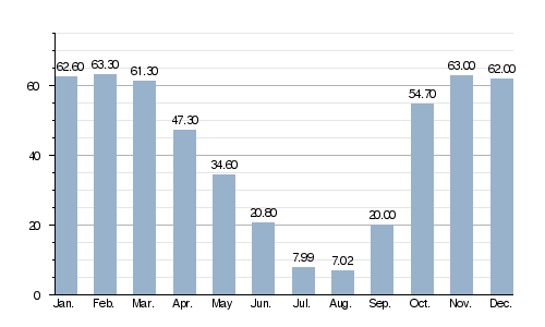
Average monthly discharge (m3/s) at Agden
This chart shows how the river's water flow changes throughout the year. You can see that more water flows in winter and spring. Less water flows in the summer months.
Where Does the Hérault Flow?
The Hérault river begins high up on the Mont Aigoual. This mountain is part of the Cévennes mountains in southeastern Massif Central, France. The river starts at an altitude of about 1,370 m (4,495 ft).
The Hérault generally flows south. It passes through two French departments: Gard and Hérault. Both are in the Occitanie region. The river flows through 43 different towns, called communes in France. Most of these towns are in the Hérault department.
Here are some of the towns the river passes through:
- In the Gard department:
- Notre-Dame-de-la-Rouvière
- Roquedur
- Saint-André-de-Majencoules
- Saint-Julien-de-la-Nef
- Valleraugue
- In the Hérault department:
- Agde
- Agonès
- Aniane
- Argelliers
- Aspiran
- Bélarga
- Bessan
- Brissac
- Campagnan
- Canet
- Castelnau-de-Guers
- Causse-de-la-Selle
- Cazilhac
- Cazouls-d'Hérault
- Florensac
- Ganges
- Gignac
- Lagamas
- Laroque
- Lézignan-la-Cèbe
- Montagnac
- Paulhan
- Pézenas
- Le Pouget
- Pouzols
- Puéchabon
- Saint-André-de-Sangonis
- Saint-Bauzille-de-Putois
- Saint-Guilhem-le-Désert
- Saint-Jean-de-Fos
- Saint-Pargoire
- Saint-Pons-de-Mauchiens
- Saint-Thibéry
- Tressan
- Usclas-d'Hérault
The Hérault river finally reaches the Mediterranean Sea at the town of Agde. This town is also in the Hérault department.
Main Tributaries

A tributary is a smaller river or stream that flows into a larger river. The Hérault river has several important tributaries.
|
Tributaries joining from the left:
|
Tributaries joining from the right:
|
Images for kids
-
The Pont du Diable (Devil's Bridge) near Saint-Guilhem-le-Désert. It's a very old bridge from the Middle Ages.
-
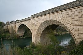
A Bridge in Gignac built in the 18th century.
-
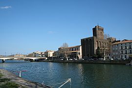
The Hérault river flowing past the Saint-Étienne d'Agde cathedral in Agde.
-
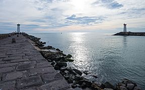
The mouth of the Hérault river where it flows into the Mediterranean Sea at Agde.


Related pages
See also
 In Spanish: Río Hérault para niños
