
Bouches-du-Rhône facts for kids
Quick facts for kids
Bouches-du-Rhône
|
|||
|---|---|---|---|

Prefecture building of the Bouches-du-Rhône department, in Marseille
|
|||
|
|||

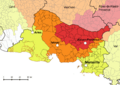
Location of Bouches-du-Rhône in France
|
|||
| Country | France | ||
| Region | Provence-Alpes- Côte d'Azur |
||
| Département | 4 March 1790 | ||
| Prefecture | Marseille | ||
| Subprefectures | Aix-en-Provence, Arles, Istres | ||
| Area | |||
| • Total | 5,087.5 km2 (1,964.3 sq mi) | ||
| Population
(2014)
|
|||
| • Total | 2,006,069 | ||
| • Density | 394.313/km2 (1,021.267/sq mi) | ||
| Time zone | UTC+1 (CET) | ||
| • Summer (DST) | UTC+2 (CEST) | ||
| ISO 3166 code | FR-13 | ||
| Arrondissements | 4 | ||
| Cantons | 29 | ||
| Communes | 135 | ||


Bouches-du-Rhône (which means "Mouths of the Rhône" in French) is a special area in the south of France. It's called a department. It gets its name from where the Rhône River meets the sea. This department is part of the Provence-Alpes-Côte d'Azur region and has the most people living in it compared to other departments in that region.
Contents
History of Bouches-du-Rhône
Bouches-du-Rhône was one of the first 83 departments created in France. This happened during the French Revolution on March 4, 1790. It was formed from a part of the old area called Provence.
At first, it was split into six smaller areas called districts. These were Tarascon, Apt, Aix, Marseille, Salon, and Arles. The main city, or capital, was Aix.
In 1800, France created new administrative areas called arrondissements. The six districts in Bouches-du-Rhône became three arrondissements: Marseille, Aix, and Tarascon. The main office, called the prefecture, moved from Aix to Marseille.
After a big battle called the Battle of Waterloo in 1815, the department was taken over by the Austrian army. They stayed there from June 1815 until November 1818.
In 1817, the Tarascon arrondissement office moved to Arles. Later, in 1981, a new arrondissement called Istres was created.
Geography of Bouches-du-Rhône
The Bouches-du-Rhône department is located in the region of Provence-Alpes-Côte d'Azur. It covers an area of about 5,087.5 square kilometers (1,964.3 square miles).
The department is surrounded by other areas:
- To the west, it borders the Gard department in the Occitanie region.
- To the north, it borders the Vaucluse department in the Provence-Alpes-Côte d'Azur region.
- To the east, it borders the Var department, also in Provence-Alpes-Côte d'Azur.
To the south, Bouches-du-Rhône meets the Mediterranean Sea. It has about 190 kilometers (118 miles) of coast.
 |
Gard | Vaucluse | |
|
| Gard | Var | |||
| Mediterranean Sea |
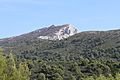
The highest point in Bouches-du-Rhône is a mountain called Bertagne. It is 1,041 meters (3,415 feet) high. You can find it in the eastern part of the department, close to the Var border.
The Rhône river forms the western border of the department. The Durance river is to the north. South of Arles, the Rhône river splits into two parts: the Grand Rhone and the Petit Rhone. The land between these two parts is called the Camargue, which is a large wetland area.
The Frioul archipelago is a group of four islands. They are in the Mediterranean Sea, about 4 kilometers (2.5 miles) away from Marseille.
Climate in Bouches-du-Rhône
The area around Marseille, which is about 35 meters (115 feet) above sea level, has a climate with dry summers. This type of weather is known as a "Mediterranean climate".
On average, Marseille gets about 584.2 millimeters (23 inches) of precipitation each year. October is usually the wettest month, with about 94 millimeters (3.7 inches) of rain. July is the driest month, with only about 15.2 millimeters (0.6 inches) of rain.
The average temperature in Marseille for the whole year is 15°C (59°F). July is the warmest month, with an average temperature of 23.9°C (75°F). January is the coolest month, with an average temperature of 6.7°C (44.1°F).
| Climate data for Marseille, France | |||||||||||||
|---|---|---|---|---|---|---|---|---|---|---|---|---|---|
| Month | Jan | Feb | Mar | Apr | May | Jun | Jul | Aug | Sep | Oct | Nov | Dec | Year |
| Mean daily maximum °C (°F) | 10 (50) |
11 (52) |
14 (57) |
17 (63) |
21 (70) |
25 (77) |
28 (82) |
28 (82) |
25 (77) |
20 (68) |
14 (57) |
11 (52) |
19 (66) |
| Daily mean °C (°F) | 6 (43) |
7 (45) |
10 (50) |
12 (54) |
16 (61) |
21 (70) |
23 (73) |
23 (73) |
20 (68) |
15 (59) |
10 (50) |
7 (45) |
14 (58) |
| Mean daily minimum °C (°F) | 2 (36) |
3 (37) |
5 (41) |
6 (43) |
12 (54) |
16 (61) |
18 (64) |
18 (64) |
15 (59) |
11 (52) |
6 (43) |
3 (37) |
10 (49) |
| Average rainfall mm (inches) | 40 (1.6) |
40 (1.6) |
40 (1.6) |
40 (1.6) |
40 (1.6) |
20 (0.8) |
10 (0.4) |
20 (0.8) |
60 (2.4) |
90 (3.5) |
70 (2.8) |
50 (2.0) |
520 (20.7) |
| Source: Weatherbase.com [1] | |||||||||||||
How Bouches-du-Rhône is Governed
Bouches-du-Rhône is run by a group called the Departmental Council of Bouches-du-Rhône. Their main office is in Marseille. The department is part of the Provence-Alpes-Côte d'Azur region.
Local Divisions of Bouches-du-Rhône
The department is divided into smaller areas to help manage it. There are:
- 4 arrondissements (which are like large districts)
- 29 cantons (smaller administrative areas)
- 135 communes (which are like towns or municipalities)
Here is a list of the arrondissements in Bouches-du-Rhône:
| Code | Arrondissement | Main City | Population (2014) |
Area (km²) |
People per km² |
Number of Communes |
|---|---|---|---|---|---|---|
| 131 | Aix-en-Provence | Aix-en-Provence | 429,436 | 1,532.4 | 280.2 | 44 |
| 132 | Arles | Arles | 205,529 | 2,284.3 | 90.0 | 36 |
| 133 | Marseille | Marseille | 1,058,615 | 671.6 | 1,576.3 | 37 |
| 134 | Istres | Istres | 312,489 | 599.3 | 521.4 | 18 |
Here are the 29 cantons of the Bouches-du-Rhône department. These were reorganized in March 2015:
- Aix-en-Provence-1 (1301)
- Aix-en-Provence-2 (1302)
- Allauch (1303)
- Arles (1304)
- Aubagne (1305)
- Berre-l'Étang (1306)
- Châteaurenard (1307)
- La Ciotat (1308)
- Gardanne (1309)
- Istres (1310)
- Marignane (1311)
- Marseille-1 (1312)
- Marseille-2 (1313)
- Marseille-3 (1314)
- Marseille-4 (1315)
- Marseille-5 (1316)
- Marseille-6 (1317)
- Marseille-7 (1318)
- Marseille-8 (1319)
- Marseille-9 (1320)
- Marseille-10 (1321)
- Marseille-11 (1322)
- Marseille-12 (1323)
- Martigues (1324)
- Pélissanne (1325)
- Salon-de-Provence-1 (1326)
- Salon-de-Provence-2 (1327)
- Trets (1328)
- Vitrolles (1329)
Population of Bouches-du-Rhône
The people who live in the Bouches-du-Rhône department are called Buccorhodaniens (for men) or Buccorhodaniennes (for women) in French.
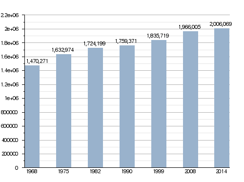
In 2014, Bouches-du-Rhône had a population of 2,006,069 people. This means there were about 394.3 inhabitants for every square kilometer. The arrondissement of Marseille had the most people, with 1,058,615 residents.
Here's how the population of Bouches-du-Rhône has changed over the years:
Evolution of the population in Bouches-du-Rhône
These are the 10 communes (towns or cities) in Bouches-du-Rhône with the most people:
| City | Population (2014) |
Arrondissement |
|---|---|---|
| Marseille | 858,120 | Marseille |
| Aix-en-Provence | 142,149 | Aix-en-Provence |
| Arles | 52,697 | Arles |
| Martigues | 48,870 | Istres |
| Aubagne | 45,128 | Marseille |
| Salon-de-Provence | 44,187 | Aix-en-Provence |
| Istres | 43,463 | Istres |
| La Ciotat | 35,631 | Marseille |
| Vitrolles | 34,236 | Istres |
| Marignane | 34,154 | Istres |
Gallery
-
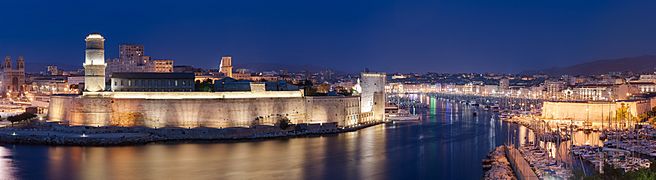
Marseille, the main city of the region.

-
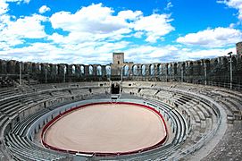
Arles Amphitheatre
-
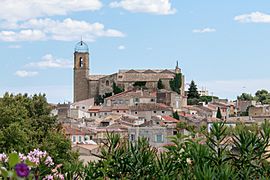
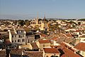
Istres - historical center


Related pages
Images for kids
-
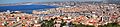
Marseille, second-largest city of France and Bouches-du-Rhône's prefecture
-
TER PACA near Le Rove, on the Mediterranean coast
-
Seismic risk in the department
-
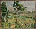
Paul Cézanne's Mont Sainte-Victoire and the Viaduct of the Arc River Valley
-
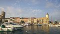
Arles
-
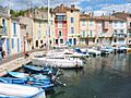
Martigues
-
Istres
-
Salon-de-Provence
-
La Ciotat
-
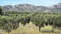
Landscape near Cassis
-
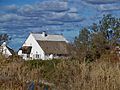
Gardian house in the Camargue
-
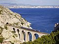
Mediterranean coast near La Ciotat
-
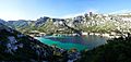
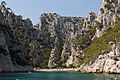
Calanque de Sormiou
-
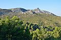
Garlaban
-
Alpilles
-
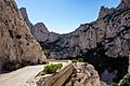
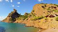
Calanques
-
Montagne Sainte-Victoire


.jpg)


.jpg)
.jpg)


.jpg)

See also
 In Spanish: Bocas del Ródano para niños
