
Ardèche facts for kids
Quick facts for kids
Ardèche
|
|||
|---|---|---|---|
|
|||

Location of Ardèche in France
|
|||
| Country | France | ||
| Region | Auvergne-Rhône-Alpes | ||
| Prefecture | Privas | ||
| Subprefectures | Largentière Tournon-sur-Rhône |
||
| Area | |||
| • Total | 5,528.6 km2 (2,134.6 sq mi) | ||
| Population
(2014)
|
|||
| • Total | 322,381 | ||
| • Density | 58.3115/km2 (151.0261/sq mi) | ||
| Demonym(s) | Ardéchois | ||
| Time zone | UTC+1 (CET) | ||
| • Summer (DST) | UTC+2 (CEST) | ||
| Department number | 07 | ||
| Arrondissements | 3 | ||
| Cantons | 17 | ||
| Communes | 339 | ||
| French Land Register data, which exclude estuaries, and lakes, ponds, and glaciers larger than 1 km2 | |||


Ardèche (pronounced Ar-DESH) is a special area in south-central France. It's called a "département" and is part of the Auvergne-Rhône-Alpes region. This area gets its name from the beautiful Ardèche river that flows through it.
Contents
History of Ardèche
How Ardèche Was Formed
The Ardèche department was created on March 4, 1790. It started with seven smaller areas called districts. These districts included Annonay, Aubenas, and Privas.
At first, the main city, or capital, changed between Privas, Annonay, Aubenas, and Tournon. But by September 1790, Privas became the only capital of the department.
Changes Over Time
In 1800, France changed its administrative system. The seven districts in Ardèche were reorganized into three larger areas called arrondissements. These new arrondissements were Privas, L'Argentière, and Tournon.
Later, on March 18, 1988, the town of Tournon officially changed its name to Tournon-sur-Rhône.
Geography of Ardèche
Where Is Ardèche Located?
Ardèche is part of the Auvergne-Rhône-Alpes region in France. It covers an area of about 5,528.6 square kilometers (2,134.6 square miles).
The department is surrounded by seven other departments from three different regions:
- Auvergne-Rhône-Alpes region:
- Loire (to the north)
- Isère (to the northeast)
- Drôme (to the east)
- Haute-Loire (to the west)
- Provence-Alpes-Côte d'Azur region:
- Vaucluse (to the southeast)
- Occitanie region:
 |
Haute-Loire | Loire | Isère | |
| Haute-Loire | Drôme | |||
| Lozère | Gard | Vaucluse |
Mountains and Rivers
The highest point in Ardèche is Mont Mézenc. This mountain is 1,753 meters (5,751 feet) tall. It is located in the northwest part of the department, right on the border with the Haute-Loire department.
The lowest point in Ardèche is where the Ardèche river flows into the Rhône river. This spot is about 40 meters (130 feet) above sea level.
The main rivers in Ardèche are:
- The Loire: This river flows through the western part of the department and eventually reaches the Atlantic Ocean.
- The Rhône: This river forms the eastern border of Ardèche and flows into the Mediterranean Sea.
- The Ardèche: This river is a smaller river that flows into the Rhône.
The Allier river also forms part of the border between Ardèche and the Lozère department for about 20 kilometers (12 miles).
Climate in Ardèche
The climate in Ardèche varies. The area around Privas has an "Oceanic climate", which means it has mild temperatures and rainfall throughout the year. The southern part of the department has a Mediterranean climate, which means it has hot, dry summers and mild, wet winters.
Administration of Ardèche
Ardèche is managed by a group called the Departmental Council of Ardèche. This council is based in Privas, which is the main city. The department is part of the larger Auvergne-Rhône-Alpes region.
How Ardèche is Divided
Ardèche is divided into smaller administrative areas to help manage it. These include:
- 3 arrondissements (which are like large districts)
- 17 cantons (smaller administrative areas)
- 339 communes (which are like towns or municipalities)
Arrondissements of Ardèche
Here are the three main arrondissements in Ardèche:
- Largentière: Its capital is Largentière. In 2014, it had about 98,821 people.
- Privas: Its capital is Privas. In 2014, it had about 87,774 people.
- Tournon-sur-Rhône: Its capital is Tournon-sur-Rhône. In 2014, it had about 135,786 people.
Cantons of Ardèche
After a reorganization in March 2015, Ardèche has 17 cantons. Here are some of them:
- Annonay-1
- Annonay-2
- Aubenas-1
- Aubenas-2
- Bourg-Saint-Andéol
- Le Cheylard
- Guilherand-Granges
- Lamastre
- Le Pouzin
- Privas
- Sarras
- Le Teil
- Thueyts
- Tournon-sur-Rhône
- Vallon-Pont-d'Arc
- Les Vans
- La Voulte-sur-Rhône
People of Ardèche
The people who live in Ardèche are called Ardéchois (pronounced Ar-desh-WAH) in French. If you're talking about women, they are called Ardéchoises.
In 2014, Ardèche had a population of 322,381 people. This means there were about 58.3 people living in each square kilometer. The arrondissement of Tournon-sur-Rhône had the most people, with 135,786 residents.
Largest Towns in Ardèche
Here are some of the largest towns in Ardèche based on their population in 2014:
- Annonay: 16,302 people
- Aubenas: 11,917 people
- Guilherand-Granges: 10,841 people
- Tournon-sur-Rhône: 10,558 people
- Le Teil: 8,376 people
- Privas: 8,313 people
- Saint-Péray: 7,494 people
- Bourg-Saint-Andéol: 7,236 people
Gallery


Related pages
- Cantons of the Ardèche department
- Arrondissements of the Ardèche department
- Communes of the Ardèche department
Images for kids
-
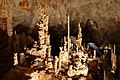
The Aven d'Orgnac is one of Ardèche's many protected caves.
-
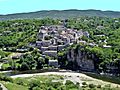
Balazuc (Latin: Baladunum) was founded circa 3000 BCE
-
The construction of the Château d'Aubenas began in the 12th century.
-

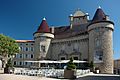
Château de Crussol
-
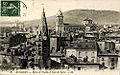
Annonay in the early 20th century
-
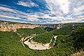
Cirque de la Madeleine
-
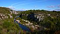
Cance Valley
-
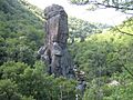
Gorges du Cassezac
-
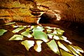
Cave near Bidon
-
Ruoms has become a tourist attraction in recent years.


See also
 In Spanish: Ardèche para niños
