
Isère facts for kids
Quick facts for kids
Isère
|
|||
|---|---|---|---|

Prefecture building of the Isère department, in Grenoble
|
|||
|
|||

Location of Isère in France
|
|||
| Country | France | ||
| Region | Auvergne-Rhône-Alpes | ||
| Département | 1790 | ||
| Prefecture | Grenoble | ||
| Subprefectures | La Tour-du-Pin, Vienne | ||
| Area | |||
| • Total | 7,431.5 km2 (2,869.3 sq mi) | ||
| Population
(2014)
|
|||
| • Total | 1,243,597 | ||
| • Density | 167.3413/km2 (433.4120/sq mi) | ||
| Demonym(s) | Isérois or Iserans | ||
| Time zone | UTC+1 (CET) | ||
| • Summer (DST) | UTC+2 (CEST) | ||
| ISO 3166 code | FR-38 | ||
| Arrondissements | 3 | ||
| Cantons | 29 | ||
| Communes | 521 | ||
| Website | www.isere.fr | ||


Isère is a special area in eastern France called a département. It is part of the Auvergne-Rhône-Alpes region. The département is named after the Isère River, which flows through it.
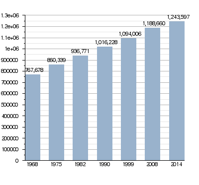
The capital city of Isère is Grenoble. In 2014, about 1.2 million people lived here. The people from Isère are called Isérois (for boys and men) or Iséroises (for girls and women).
Contents
History of Isère
Isère was one of the first 83 départements created in France. This happened during the French Revolution on March 4, 1790. Its first capital was Moirans.
The area used to be part of an old province called Dauphiné. In 1790, the capital was moved from Moirans to Grenoble.
How Isère's Districts Changed
In 1800, France created new administrative areas called arrondissements. Isère was divided into four of these: Grenoble, Saint-Marcellin, La Tour-du-Pin, and Vienne.
However, in 1926, the arrondissement of Saint-Marcellin was removed. Today, Isère has three arrondissements.
Geography of Isère
Isère is located in the Auvergne-Rhône-Alpes region of France. It covers an area of about 7,431.5 square kilometers (2,869 square miles).
Neighboring Departments
Isère shares its borders with seven other départements from two different regions:
- From the Auvergne-Rhône-Alpes region:
- From the Provence-Alpes-Côte d'Azur region:
- Hautes-Alpes (to the southeast)
 |
Rhône | Ain | |
|
| Loire Ardèche |
Savoie | |||
| Drôme | Hautes-Alpes |
Mountains and Rivers
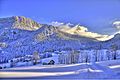
The highest point in Isère is a mountain peak called Pic Lory. It stands at 4,088 meters (13,412 feet) tall.
The main rivers flowing through the département are the Rhône River and its smaller rivers, called tributaries. These include the Isère River and the Bourbre River.
Climate in Isère
The climate in Isère, especially around Grenoble, is known as an "Oceanic climate". This means it has mild temperatures and rainfall throughout the year, similar to many coastal areas.
Government and Administration
Isère is governed by the Departmental Council of Isère. This council is based in Grenoble, the capital city. The département is also part of the larger Auvergne-Rhône-Alpes region.
Administrative Divisions of Isère
Isère is divided into smaller administrative areas to help manage it. These include:
- 3 arrondissements (which are like large districts)
- 29 cantons (smaller administrative areas)
- 521 communes (which are like towns or municipalities)
Arrondissements of Isère
Here are the three main arrondissements in Isère, along with their capitals and populations (as of 2014):
| Arrondissement | Capital | Population (2014) |
Area (km²) |
Communes |
|---|---|---|---|---|
| Grenoble | Grenoble | 758,956 | 4,714.7 | 267 |
| La Tour-du-Pin | La Tour-du-Pin | 270,681 | 1,489.7 | 137 |
| Vienne | Vienne | 213,960 | 1,227.1 | 117 |
Cantons of Isère
After a change in March 2015, Isère now has 29 cantons. These are smaller areas used for elections and local administration.
- Bièvre
- Bourgoin-Jallieu
- Chartreuse-Guiers
- Charvieu-Chavagneux
- Échirolles
- Fontaine-Seyssinet
- Fontaine-Vercors
- Le Grand-Lemps
- Grenoble-1
- Grenoble-2
- Grenoble-3
- Grenoble-4
- Le Haut-Grésivaudan
- L’Isle-d'Abeau
- Matheysine-Trièves
- Meylan
- Morestel
- Le Moyen Grésivaudan
- Oisans-Romanche
- Le Pont-de-Claix
- Roussillon
- Saint-Martin-d'Hères
- Le Sud Grésivaudan
- La Tour-du-Pin
- Tullins
- La Verpillière
- Vienne-1
- Vienne-2
- Voiron
Population and Major Cities
In 2014, Isère had a total population of 1,243,597 people. This means there were about 167 people living in each square kilometer. The arrondissement of Grenoble is the most populated, with over 750,000 residents.
Population Growth Over Time
The population of Isère has grown steadily over the years.
Largest Communes in Isère
Here are the cities and towns in Isère with the most people, based on 2014 data:
| City | Population (2014) |
Arrondissement |
|---|---|---|
| Grenoble | 160,779 | Grenoble |
| Saint-Martin-d'Hères | 38,100 | Grenoble |
| Échirolles | 35,875 | Grenoble |
| Vienne | 29,096 | Vienne |
| Bourgoin-Jallieu | 27,366 | La Tour-du-Pin |
| Fontaine | 22,366 | Grenoble |
| Voiron | 20,162 | Grenoble |
| Villefontaine | 18,463 | La Tour-du-Pin |
| Meylan | 17,323 | Grenoble |
| L'Isle-d'Abeau | 16,040 | La Tour-du-Pin |
Gallery


Related pages
Images for kids
-
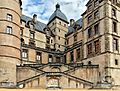
The Château de Vizille, where important meetings took place after the 1788 Day of the Tiles in Grenoble. It is now home to the Musée de la Révolution française.
-
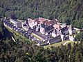
The Grande Chartreuse monastery.
-
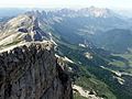
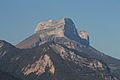
The Grand Veymont mountain.
-
The Dent de Crolles mountain.
-
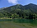
Le Haut-Bréda area with a lake and mountain.
-
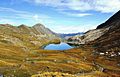
A view of the Queyras Valley.
-
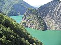
Lac de Monteynard-Avignonet, a beautiful lake.
-
The village of Saint-Christophe-sur-Guiers in Chartreuse.


.JPG)


See also
 In Spanish: Isère para niños
