
Hautes-Alpes facts for kids
Quick facts for kids
Hautes-Alpes
|
|||
|---|---|---|---|

Prefecture building of the Hautes-Alpes department, in Gap
|
|||
|
|||

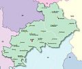
Location of Hautes-Alpes in France
|
|||
| Country | France | ||
| Region | Provence-Alpes-Côte d'Azur | ||
| Département | 4 March 1790 | ||
| Prefecture | Gap | ||
| Subprefectures | Briançon | ||
| Area | |||
| • Total | 5,548.7 km2 (2,142.4 sq mi) | ||
| Population
(2014)
|
|||
| • Total | 139,883 | ||
| • Density | 25.2100/km2 (65.2937/sq mi) | ||
| Demonym(s) | Haut-Alpins | ||
| Time zone | UTC+1 (CET) | ||
| • Summer (DST) | UTC+2 (CEST) | ||
| ISO 3166 code | FR-05 | ||
| Arrondissements | 2 | ||
| Cantons | 15 | ||
| Communes | 167 | ||
| Website | www.hautes-alpes.fr | ||


Hautes-Alpes (pronounced "Oht-Zalp") is a special area in southeastern France. It's called a "department," which is like a county or region. This department is part of the Provence-Alpes-Côte d'Azur region. It gets its name from the Alps mountain range because it's high up in the mountains. The main city, or "prefecture," of Hautes-Alpes is Gap.
Contents
History of Hautes-Alpes
The Hautes-Alpes department was created during the French Revolution on March 4, 1790. It was one of the first 83 departments in France. It was formed from the southeastern part of an old French area called the Dauphiné.
At first, Hautes-Alpes was split into four smaller areas called "districts": Briançon, Embrun, Gap, and Serres. Chorges was the first capital city. However, in the same year, the capital was moved to Gap.
In 1800, France changed its administrative divisions. The four districts became three "arrondissements" (which are like administrative districts): Gap, Briançon, and Embrun. Later, in 1926, the Embrun arrondissement was removed.
After the Battle of Waterloo in 1815, soldiers from Austria and the Kingdom of Sardinia took over the department for a short time. During World War II, the department was occupied by fascist Italy.
Geography and Mountains
Hautes-Alpes is located in the Provence-Alpes-Côte d'Azur region. It covers an area of about 5,548.7 square kilometers (2,142 square miles).
The department is surrounded by the Piedmont region in Italy to the east. It also shares borders with four other French departments:
- To the south: Alpes-de-Haute-Provence (in the same region)
- To the north: Isère (in the Auvergne-Rhône-Alpes region)
- To the northeast: Savoie (in the Auvergne-Rhône-Alpes region)
- To the west: Drôme (in the Auvergne-Rhône-Alpes region)
 |
Isère | Savoie | |
|
| Drôme | Piedmont (Italy) | |||
| Alpes-de-Haute-Provence |
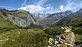
Hautes-Alpes is deep within the Alps mountain range. The land here is very high, with an average elevation of over 1,000 meters (3,280 feet). The village of Saint-Véran is one of the highest villages in all of Europe. Also, Gap and Briançon are the highest main cities (prefecture and subprefecture) in France.
The highest point in Hautes-Alpes is Barre des Écrins, which is 4,102 meters (13,458 feet) tall. It is located in the village area of Pelvoux. The lowest point is in the valley of the Buëch river, at an altitude of 470 meters (1,542 feet).
The main rivers flowing through Hautes-Alpes are the Durance, which flows into the Rhône river, the Buëch, and the Drac.
Climate in Hautes-Alpes
The climate in places like Embrun is known as an "Oceanic climate." This means it has mild temperatures and rain throughout the year.
On average, Embrun gets about 1,173.5 millimeters (46.2 inches) of rain each year. May is usually the wettest month, with about 119.4 millimeters (4.7 inches) of rain. July is the driest month, with about 66 millimeters (2.6 inches) of rain.
The average temperature for the year in Embrun is 10.7°C (51.3°F). July is the warmest month, with an average temperature of 20.2°C (68.4°F). January is the coolest month, with an average temperature of 2°C (35.6°F).
| Climate data for Embrun, France | |||||||||||||
|---|---|---|---|---|---|---|---|---|---|---|---|---|---|
| Month | Jan | Feb | Mar | Apr | May | Jun | Jul | Aug | Sep | Oct | Nov | Dec | Year |
| Mean daily maximum °C (°F) | 6.8 (44.2) |
8.4 (47.1) |
12.4 (54.3) |
15.2 (59.4) |
19.7 (67.5) |
23.8 (74.8) |
27.3 (81.1) |
27.0 (80.6) |
22.3 (72.1) |
17.1 (62.8) |
10.8 (51.4) |
7.1 (44.8) |
16.5 (61.7) |
| Daily mean °C (°F) | 2 (36) |
3 (37) |
6.5 (43.7) |
9.3 (48.7) |
13.6 (56.5) |
17.2 (63.0) |
20.2 (68.4) |
20 (68) |
16 (61) |
11.7 (53.1) |
6 (43) |
2.7 (36.9) |
10.7 (51.3) |
| Mean daily minimum °C (°F) | −2.8 (27.0) |
−2.5 (27.5) |
0.6 (33.1) |
3.4 (38.1) |
7.5 (45.5) |
10.6 (51.1) |
13.1 (55.6) |
12.9 (55.2) |
9.6 (49.3) |
6.2 (43.2) |
1.1 (34.0) |
−1.7 (28.9) |
4.8 (40.7) |
| Average rainfall mm (inches) | 91.7 (3.61) |
83.2 (3.28) |
84.7 (3.33) |
115.5 (4.55) |
118.4 (4.66) |
88.7 (3.49) |
67.1 (2.64) |
84.2 (3.31) |
109.3 (4.30) |
114.3 (4.50) |
108.7 (4.28) |
108.2 (4.26) |
1,174 (46.21) |
| Source: Weatherbase.com [1] | |||||||||||||
How Hautes-Alpes is Governed
Hautes-Alpes is run by the Departmental Council of Hautes-Alpes. This council meets in Gap, the main city. The department is part of the larger Provence-Alpes-Côte d'Azur region.
Administrative Divisions
Hautes-Alpes is divided into different administrative areas to help manage it. There are 2 "arrondissements" (large districts), 15 "cantons" (smaller areas for elections), and 167 "communes" (individual towns or villages).
| INSEE code |
Arrondissement | Capital | Population (2014) |
Area (km²) |
Density (Inh./km²) |
Communes |
|---|---|---|---|---|---|---|
| 051 | Briançon | Briançon | 35,752 | 2,138.1 | 16.7 | 37 |
| 052 | Gap | Gap | 104,131 | 3,410.5 | 30.5 | 130 |
Here is a list of the 15 "cantons" in Hautes-Alpes. These were reorganized in March 2015:
- L'Argentière-la-Bessée (0501)
- Briançon-1 (0502)
- Briançon-2 (0503)
- Chorges (0504)
- Embrun (0505)
- Gap-1 (0506)
- Gap-2 (0507)
- Gap-3 (0508)
- Gap-4 (0509)
- Guillestre (0510)
- Laragne-Montéglin (0511)
- Saint-Bonnet-en-Champsaur (0512)
- Serres (0513)
- Tallard (0514)
- Veynes (0515)
Population of Hautes-Alpes
The people who live in Hautes-Alpes are called Haut-Alpins in French.
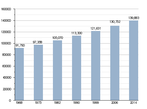
In 2013, Hautes-Alpes had a population of 139,883 people. This means there were about 25.2 people living in each square kilometer. The arrondissement of Gap has the most people, with 104,131 residents.
Evolution of the population in Hautes-Alpes
Here are the towns (communes) in the department with the most people:
| City | Population (2014) |
Arrondissement |
|---|---|---|
| Gap | 40,225 | Gap |
| Briançon | 12,392 | Briançon |
| Embrun | 6,150 | Gap |
| Laragne-Montéglin | 3,480 | Gap |
| Veynes | 3,151 | Gap |
| Chorges | 2,791 | Gap |
| La Bâtie-Neuve | 2,468 | Gap |
| Guillestre | 2,323 | Briançon |
| L'Argentière-la-Bessée | 2,317 | Briançon |
| Tallard | 2,061 | Gap |
| Saint-Bonnet-en-Champsaur | 2,034 | Gap |
Gallery
-
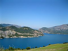
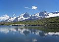
Lake of Serre-Ponçon.
-
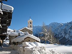
Saint-Véran-en-Queyras
-
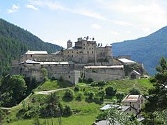
Fort Queyras.


Related pages
Images for kids
-
Map of Hautes-Alpes.
-
Embrun
-
Massif des Écrins
-
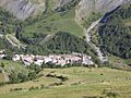
La Grave
-
La Meije
-
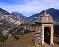
The Alps and the Guil valley seen from Fort Mont-Dauphin


See also
 In Spanish: Altos Alpes para niños
