
Alpes-de-Haute-Provence facts for kids
Quick facts for kids
Alpes-de-Haute-Provence
|
|||
|---|---|---|---|

Prefecture building of the Alpes-de-Haute-Provence department, in Digne-les-Bains
|
|||
|
|||

Location of Alpes-de-Haute-Provence in France
|
|||
| Country | France | ||
| Region | Provence-Alpes-Côte d'Azur | ||
| Département | 4 March 1790 | ||
| Prefecture | Digne-les-Bains | ||
| Subprefectures | Barcelonnette, Castellane, Forcalquier | ||
| Area | |||
| • Total | 6,925.2 km2 (2,673.8 sq mi) | ||
| Population
(2014)
|
|||
| • Total | 161,588 | ||
| • Density | 23.33333/km2 (60.4331/sq mi) | ||
| Time zone | UTC+1 (CET) | ||
| • Summer (DST) | UTC+2 (CEST) | ||
| ISO 3166 code | FR-04 | ||
| Arrondissements | 4 | ||
| Cantons | 15 | ||
| Communes | 198 | ||
| Website | www.mondepartement04.fr | ||


Alpes-de-Haute-Provence (Occitan: Aups d'Auta Provença) is a special area in the south of France. It is called a department. It belongs to the Provence-Alpes-Côte d'Azur region. The main city and capital of the department is Digne-les-Bains.
Before 1970, this department was known by a different name: Basses-Alpes.
Contents
A Look at History

The department of Alpes-de-Haute-Provence was created a long time ago, on March 4, 1790. This happened during the French Revolution. Its first name was Nord-de-Provence. Soon after, it was called Haute-Provence, and then Basses-Alpes.
It was first divided into five smaller areas called districts. These were Barcelonnette, Castellane, Digne, Forcalquier, and Sisteron. Digne was chosen as the capital.
Later, in 1793, a new department called Vaucluse was formed. Parts of Basses-Alpes were used to create this new area. In 1810, another small part of Basses-Alpes moved to the Hautes-Alpes department.
In 1800, the districts were changed into arrondissements. There were still five of them: Barcelonnette, Castellane, Digne, Forcalquier, and Sisteron.
Over time, some changes happened. In 1926, the arrondissements of Castellane and Sisteron were removed. But in 1942, Castellane became an arrondissement again.
During World War II, the department was taken over by Italy.
The capital city, Digne, changed its name to Digne-les-Bains in 1988. Then, on April 13, 1970, the entire department of Basses-Alpes got its current name: Alpes-de-Haute-Provence.
Exploring the Geography
Alpes-de-Haute-Provence is located in the Provence-Alpes-Côte d'Azur region. It covers an area of about 6,925 square kilometers (2,674 square miles).
The department shares its borders with Italy and five other French departments. These departments are in two different regions:
- In the Provence-Alpes-Côte d'Azur region:
* Hautes-Alpes to the north. * Alpes-Maritimes to the east. * Var to the south. * Vaucluse to the west.
- In the Auvergne-Rhône-Alpes region:
* Drôme to the northwest.
 |
Drôme | Hautes-Alpes | Italy | |
| Vaucluse | Alpes-Maritimes | |||
| Var |
Mountains and Rivers
The highest point in the department is a mountain called Aiguille de Chambeyron. It is very tall, reaching 3,412 meters (11,194 feet) high. Other tall mountains include Brec de Chambeyron (3,389 meters), Pics de la Font Sancte (3,385 meters), Grand Bérard (3,046 meters), and Tête de Siguret (3,032 meters).
The most important river in Alpes-de-Haute-Provence is the Durance. It flows through the western part of the department. The Durance is a tributary (a smaller river that flows into a larger one) of the Rhône river. Its main smaller rivers are the Bléone and Verdon. The Var river also flows through the eastern part of the department.
Climate Information
The climate in Alpes-de-Haute-Provence is generally mild, like an "Oceanic climate." This means it has moderate temperatures and rainfall.
On average, the area gets about 917 millimeters (36 inches) of rain each year. October is usually the wettest month, while February is the driest.
The average temperature for the year is around 12.9°C (55.2°F). July is the warmest month, with an average temperature of about 22.7°C (72.9°F). January is the coolest, with an average temperature of about 4.3°C (39.7°F).
How the Department is Run
Alpes-de-Haute-Provence is managed by a group called the Departmental Council of Alpes-de-Haute-Provence. This council is located in Digne-les-Bains. The department is part of the larger Provence-Alpes-Côte d'Azur region.
Divisions of the Department
The department is divided into smaller parts to help with its administration. There are 4 main arrondissements (like large districts). These are further divided into 15 cantons and 198 communes (which are like towns or small cities).
Here are the arrondissements of Alpes-de-Haute-Provence:
| INSEE code |
Arrondissement | Capital | Population (2014) |
Area (km²) |
Density (Inh./km²) |
Communes |
|---|---|---|---|---|---|---|
| 041 | Barcelonnette | Barcelonnette | 8,004 | 1,027.7 | 7.8 | 14 |
| 042 | Castellane | Castellane | 9,493 | 1,320.4 | 7.2 | 41 |
| 043 | Digne-les-Bains | Digne-les-Bains | 55,758 | 2,465.5 | 22.6 | 46 |
| 044 | Forcalquier | Forcalquier | 88,333 | 2,111.6 | 41.8 | 97 |
Here is a list of the 15 cantons in the Alpes-de-Haute-Provence department. These were reorganized in March 2015:
- Barcelonnette (0401)
- Castellane (0402)
- Château-Arnoux-Saint-Auban (0403)
- Digne-les-Bains-1 (0404)
- Digne-les-Bains-2 (0405)
- Forcalquier (0406)
- Manosque-1 (0407)
- Manosque-2 (0408)
- Manosque-3 (0409)
- Oraison (0410)
- Reillanne (0411)
- Riez (0412)
- Seyne (0413)
- Sisteron (0414)
- Valensole (0415)
People and Population
The people who live in Alpes-de-Haute-Provence are called Bas-Alpins (for men) or Bas-Alpines (for women) in French. This name comes from the department's old name, Basses-Alpes.
In 2014, Alpes-de-Haute-Provence had a population of 161,588 people. This means there were about 23.3 people living in each square kilometer (60.3 people per square mile). The arrondissement of Forcalquier had the most people, with 88,333 inhabitants.
How the population has changed in Alpes-de-Haute-Provence

Here are the 10 communes (towns or cities) in the department with the most people:
| City | Population (2014) |
Arrondissement |
|---|---|---|
| Manosque | 21,941 | Forcalquier |
| Digne-les-Bains | 16,304 | Digne-les-Bains |
| Sisteron | 7,281 | Forcalquier |
| Oraison | 5,792 | Digne-les-Bains |
| Château-Arnoux-Saint-Auban | 5,210 | Forcalquier |
| Forcalquier | 4,910 | Forcalquier |
| Villeneuve | 4,048 | Forcalquier |
| Pierrevert | 3,690 | Forcalquier |
| Les Mées | 3,629 | Digne-les-Bains |
| Sainte-Tulle | 3,398 | Forcalquier |
Gallery
-
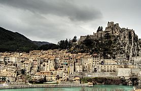
Sisteron
-
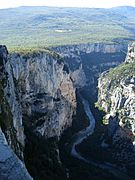
Verdon river gorge


.jpg)


Related pages
- Arrondissements of the Alpes-de-Haute-Provence department
- Communes of the Alpes-de-Haute-Provence department
Images for kids
-
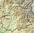
Hydrology and topography
-

Lavender fields in Valensole
-
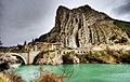
Rocher de La Baume
-
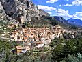
Moustiers-Sainte-Marie


.jpg)

See also
 In Spanish: Alpes de Alta Provenza para niños
