Aiguille de Chambeyron facts for kids
Quick facts for kids Aiguille de Chambeyron |
|
|---|---|

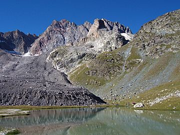
Aiguille de Chambeyron from Lake Marinet
|
|
| Highest point | |
| Elevation | 3,412 m (11,194 ft) |
| Prominence | 771 m (2,530 ft) |
| Geography | |
|
Lua error in Module:Location_map at line 420: attempt to index field 'wikibase' (a nil value).
|
|
| Location | Provence-Alpes-Côte d'Azur, France |
| State/Province | FR |
| Parent range | Cottian Alps |
| Climbing | |
| First ascent | 1879 |
| Easiest route | South side, from the Chambeyron Hut |
Aiguille de Chambeyron is a tall mountain in France. It stands close to the border with Italy. This mountain is just west of the main Alps mountain range. The Alps separate the Rhône river basin in the west from the Po river basin in the east.
It is the highest peak in the Alps south of Monte Viso.
Contents
About Aiguille de Chambeyron
Aiguille de Chambeyron is located in southeastern France. You can find it in the northeast part of the Alpes-de-Haute-Provence area. This area is part of the Provence-Alpes-Côte d'Azur region.
The mountain is 3,412 m (11,194 ft) high. This makes it the highest point in its department. It is also the highest point in the historical region of Provence.
The mountain is part of the Chambeyron Massif. This is a group of mountains within the Cottian Alps. Aiguille de Chambeyron has two summits, or tops. The western summit is a little bit higher than the other.
On the north side of the mountain, there are two small glaciers. These glaciers are mostly covered with rocks. They are called the Chauvet Glacier and the Marinet Glacier.
Mountain Rocks
The lower parts of Aiguille de Chambeyron are made of limestone from the Triassic period. This is a type of rock formed a very long time ago. The highest parts of the mountain are made of Jurassic limestone. This type of limestone is usually stronger and more solid.
First Climbers
The first time someone officially climbed Aiguille de Chambeyron was in 1879. A mountain climber named W.A.B. Coolidge from the United States made the climb. He was joined by Christian Almer and his son, who were from Switzerland.
How to Climb Aiguille de Chambeyron
The easiest way to climb this mountain is from its south side. This route starts from the Chambeyron hut. A hut is a small building where climbers can rest, eat, and sleep. The Chambeyron Hut is located at an altitude of 2,626 m (8,615 ft).
If you want to reach the Chambeyron Hut, you can start from the city of Barcelonette. Here is the path:
You can drive your car to the small village called Fouillouse. There is a parking lot there where you can leave your car. From Fouillouse, you would then hike to the Chambeyron Hut.
 | Jewel Prestage |
 | Ella Baker |
 | Fannie Lou Hamer |


