
Alpes-Maritimes facts for kids
Quick facts for kids
Alpes-Maritimes
|
|||
|---|---|---|---|

Nice and Côte d'Azur
|
|||
|
|||

Location of Alpes-Maritimes in France
|
|||
| Country | France | ||
| Region | Provence-Alpes-Côte d'Azur | ||
| Département | 4 February 1793 | ||
| Prefecture | Nice | ||
| Subprefecture | Grasse | ||
| Area | |||
| • Total | 4,298.6 km2 (1,659.7 sq mi) | ||
| Population
(2014)
|
|||
| • Total | 1,083,312 | ||
| • Density | 252.0151/km2 (652.716/sq mi) | ||
| Demonym(s) | Haut-Alpins | ||
| Time zone | UTC+1 (CET) | ||
| • Summer (DST) | UTC+2 (CEST) | ||
| ISO 3166 code | FR-06 | ||
| Arrondissements | 2 | ||
| Cantons | 27 | ||
| Communes | 163 | ||
| Website | www.departement06.fr | ||


Alpes-Maritimes (which means "Maritime Alps") is a special area in France called a department. It's located in the very southeast corner of the country, right next to the Mediterranean Sea. It's part of the Provence-Alpes-Côte d'Azur region.
The name Alpes-Maritimes comes from the Latin words Alpes Maritimae. This was a Roman military area set up by Emperor Augustus way back in 14 BC.
Contents
History of Alpes-Maritimes

The Alpes-Maritimes department was first created on February 4, 1793. This happened after France took over the area known as the County of Nice. The main city, or capital, was Nice. At first, it was split into three smaller areas called districts: Menton, Nice, and Puget-Théniers. A year later, in 1794, the Menton district changed its name to Fort-d'Hercule, which is now Monaco.
In 1800, France changed how its areas were organized. The districts became arrondissements. So, Nice, Monaco, and Puget-Théniers became arrondissements.
Later, in 1805, another arrondissement was added when France took over Sanremo. But after the Peace of Paris in 1814, San Remo went to another region, and the rest of the department became part of the Kingdom of Sardinia.
The Alpes-Maritimes department was created again in 1860 when Nice officially became part of France once more. Nice was still the capital. At this time, the department also included the Grasse area, which used to be part of the Var department. It was then divided into two arrondissements: Grasse and Puget-Théniers. However, the Puget-Théniers arrondissement was removed on September 10, 1926.
Geography of Alpes-Maritimes
The Alpes-Maritimes department is part of the Provence-Alpes-Côte d'Azur region. It covers an area of about 4,298.6 square kilometers (1,659.7 square miles).
This department is surrounded by other places. To the north and east, it borders the Piedmont and Liguria regions in Italy. To the south, it meets the Mediterranean Sea. It also completely surrounds the tiny country of Principality of Monaco on its west, north, and east sides.
- It is next to these French departments:
- Alpes-de-Haute-Provence (to the northwest)
- Var (to the southwest)
 |
Alpes-de-Haute-Provence | Piedmont (Italy) | |
|
| Piedmont (Italy) | ||||
| Var | Mediterranean Sea | Liguria (Italy) |
The highest mountain in the department is called Cime du Gélas. It is on the border with Italy and stands at 3,143 meters (10,312 feet) tall. The lowest point in the department is along the Mediterranean coast.
The main rivers flowing through Alpes-Maritimes include the Var, Vésubie, Tinée, Roya, Estéron, Siagne, and Loup.
Climate in Nice
The climate in Nice, a major city in Alpes-Maritimes, is known as a "Mediterranean climate". This means it has hot, dry summers and mild, wet winters.
On average, Nice gets about 734.1 millimeters (28.9 inches) of rain each year. The rainiest month is usually October, with about 132.1 millimeters (5.2 inches) of rain. July is the driest month, getting only about 12.7 millimeters (0.5 inches) of rain. On average, there are about 94 days with rain each year. April has the most rainy days (11 days), while July has the fewest (4 days).
The average temperature in Nice throughout the year is 16°C (61°F). August is usually the warmest month, with an average temperature of 24.1°C (75.4°F). January is the coolest month, with an average temperature of 9.2°C (48.6°F).
| Climate data for Nice, France | |||||||||||||
|---|---|---|---|---|---|---|---|---|---|---|---|---|---|
| Month | Jan | Feb | Mar | Apr | May | Jun | Jul | Aug | Sep | Oct | Nov | Dec | Year |
| Mean daily maximum °C (°F) | 13.1 (55.6) |
13.4 (56.1) |
15.2 (59.4) |
17.0 (62.6) |
20.7 (69.3) |
24.3 (75.7) |
27.3 (81.1) |
27.7 (81.9) |
24.6 (76.3) |
21.0 (69.8) |
16.6 (61.9) |
13.8 (56.8) |
19.6 (67.2) |
| Daily mean °C (°F) | 9.2 (48.6) |
9.7 (49.5) |
11.6 (52.9) |
13.6 (56.5) |
17.4 (63.3) |
20.9 (69.6) |
23.8 (74.8) |
24.1 (75.4) |
21.0 (69.8) |
17.4 (63.3) |
12.9 (55.2) |
10.1 (50.2) |
16.0 (60.8) |
| Mean daily minimum °C (°F) | 5.3 (41.5) |
5.9 (42.6) |
7.9 (46.2) |
10.2 (50.4) |
14.1 (57.4) |
17.5 (63.5) |
20.3 (68.5) |
20.5 (68.9) |
17.3 (63.1) |
13.7 (56.7) |
9.2 (48.6) |
6.3 (43.3) |
12.4 (54.2) |
| Average rainfall mm (inches) | 69.0 (2.72) |
44.7 (1.76) |
38.7 (1.52) |
69.3 (2.73) |
44.6 (1.76) |
34.3 (1.35) |
12.1 (0.48) |
17.8 (0.70) |
73.1 (2.88) |
132.8 (5.23) |
103.9 (4.09) |
92.7 (3.65) |
733 (28.87) |
| Source: Weatherbase.com [1] | |||||||||||||
How Alpes-Maritimes is Governed
The Alpes-Maritimes department is managed by the Departmental Council of Alpes-Maritimes. This council is located in Nice. The department is part of the larger Provence-Alpes-Côte d'Azur region.
Divisions of Alpes-Maritimes
Alpes-Maritimes is divided into several administrative areas:
- There are 2 arrondissements (which are like large districts).
- There are 27 cantons (smaller administrative areas).
- There are 163 communes (which are like towns or municipalities).
| INSEE code |
Arrondissement | Capital | Population (2014) |
Area (km²) |
Density (Inh./km²) |
Communes |
|---|---|---|---|---|---|---|
| 061 | Grasse | Grasse | 560,045 | 1,231.2 | 454.9 | 62 |
| 062 | Nice | Nice | 523,267 | 3,067.4 | 170.6 | 101 |
Here is a list of the 27 cantons in the Alpes-Maritimes department. These divisions were updated in March 2015:
- Antibes-1 (0601)
- Antibes-2 (0602)
- Antibes-3 (0603)
- Beausoleil (0604)
- Cagnes-sur-Mer-1 (0605)
- Cagnes-sur-Mer-2 (0606)
- Cannes-1 (0607)
- Cannes-2 (0608)
- Le Cannet (0609)
- Contes (0610)
- Grasse-1 (0611)
- Grasse-2 (0612)
- Mandelieu-la-Napoule (0613)
- Menton (0614)
- Nice-1 (0615)
- Nice-2 (0616)
- Nice-3 (0617)
- Nice-4 (0618)
- Nice-5 (0619)
- Nice-6 (0620)
- Nice-7 (0621)
- Nice-8 (0622)
- Nice-9 (0623)
- Tourrette-Levens (0624)
- Valbonne (0625)
- Vence (0626)
- Villeneuve-Loubet (0627)
Population of Alpes-Maritimes
People who live in Alpes-Maritimes are called Maralpins (for men) or Maralpines (for women) in French.
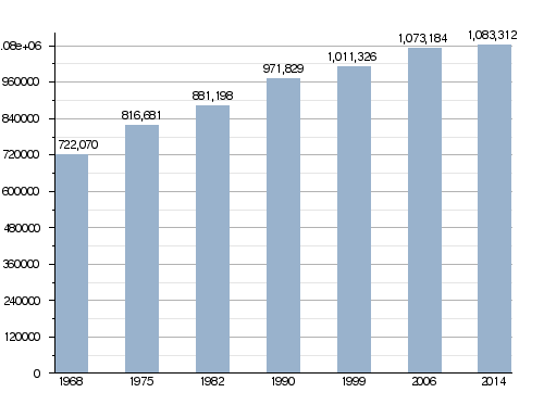
In 2014, Alpes-Maritimes had a population of 1,083,312 people. This means there were about 252.0 people living per square kilometer. The arrondissement of Grasse had the most people, with 560,045 residents.
How the population of Alpes-Maritimes has changed over time
Here are the communes (towns or cities) in the department that had more than 20,000 people in 2014:
| City | Population (2014) |
Arrondissement |
|---|---|---|
| Nice | 343,895 | Nice |
| Antibes | 75,731 | Grasse |
| Cannes | 73,744 | Grasse |
| Grasse | 50,409 | Grasse |
| Cagnes-sur-Mer | 47,811 | Grasse |
| Le Cannet | 42,454 | Grasse |
| Saint-Laurent-du-Var | 29,067 | Grasse |
| Menton | 28,563 | Nice |
| Vallauris | 26,302 | Grasse |
| Mandelieu-la-Napoule | 22,696 | Grasse |
Gallery


Related pages
Images for kids
-
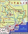
Geography of Alpes-Maritimes
-
The French Riviera, centered on Nice, attracts millions of international tourists every year.
-
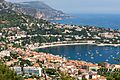
Villefranche-sur-Mer between Nice and Monaco
-
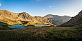
Mercantour National Park in the commune of Saint-Martin-Vésubie, which primarily covers a small town in the Alps and tourist destination
-
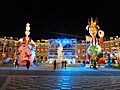
Nice Carnival (2013)
-
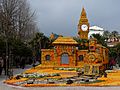
La Fête du Citron (Lemon festival) in Menton
-
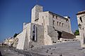
The Picasso museum in Antibes


See also
 In Spanish: Alpes Marítimos (departamento) para niños
