
Cime du Gélas facts for kids
Quick facts for kids Cime du Gélas |
|
|---|---|
| Monte Gelàs | |

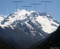
Southern side of the Cime du Gélas
|
|
| Highest point | |
| Elevation | 3,143 m (10,312 ft) |
| Prominence | 669 m (2,195 ft) |
| Geography | |
|
Lua error in Module:Location_map at line 420: attempt to index field 'wikibase' (a nil value).
|
|
| Location | Piedmont, Italy Provence-Alpes-Côte d'Azur, France |
| State/Province | FR |
| Parent range | Maritime Alps |
| Climbing | |
| First ascent | 1864 |
| Easiest route | snow/rock climb |
The Cime du Gélas (also called Monte Gelàs in Italian) is a tall mountain. It stands 3,143 meters (about 10,312 feet) high. This impressive peak is located right on the border between France and Italy.
On the French side, it is part of the Provence-Alpes-Côte d'Azur region. It is the highest point in the Mercantour National Park. On the Italian side, it belongs to the Province of Cuneo. It is also part of the Maritime Alps Natural Park.
What's in a Name?

The name of the mountain, "Gélas," comes from an old local language. It means "to freeze." This name was given because of the glaciers found on the northern side of the mountain.
Even though these glaciers have become smaller since the late 1900s, they are still there. They remind us of how cold and icy this part of the mountain can be.
Mountain Geography
Cime du Gélas is part of the Maritime Alps mountain range. This range stretches across southeastern France. The mountain is mainly made of a type of rock called gneiss. This rock is very strong and forms the core of the Mercantour-Argentera massif.
The peak of Cime du Gélas actually has two smaller tops. A deep gorge called Sella del Gelàs separates them. The northern peak is the taller of the two. It is also the easier one to climb. On top of this higher peak, you can find a small wooden sculpture of the Madonna. There is also a cross that was placed there by priests from Cuneo.
First Climbs
The first time someone was recorded climbing to the top of Cime du Gélas was in 1864. This brave climb was made by a person named Paolo di Saint-Robert.
Later, in 1894, Victor de Cessole achieved another amazing feat. He was the first person to successfully climb the mountain during the winter. Climbing in winter is much harder due to snow, ice, and colder temperatures.
Images for kids
-
Monte Gelas and nearby summits from the road to lake Rovina

See also
 In Spanish: Monte Gelas para niños
