
Siagne facts for kids
Quick facts for kids Siagne |
|
| River | |
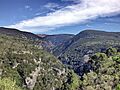
 The canyon of the Siagne river
|
|
| Country | France |
|---|---|
| Region | Provence-Alpes-Côte d'Azur |
| Departments | Alpes-Maritimes, Var |
| Tributaries | |
| - left | Vallon de Nans, Moucharonne |
| - right | Siagnole, Biançon |
| Cities | Mandelieu-la-Napoule, Pégomas, La Roquette-sur-Siagne |
| Source | Audibergue mountain |
| - location | Escragnolles, Alpes-Maritimes, Provence-Alpes-Côte d'Azur, France |
| - elevation | 1,367 m (4,485 ft) |
| - coordinates | 43°43′43″N 6°50′15″E / 43.72861°N 6.83750°E |
| Mouth | Mediterranean Sea |
| - location | Mandelieu-la-Napoule, Alpes-Maritimes, Provence-Alpes-Côte d'Azur, France |
| - elevation | 0 m (0 ft) |
| - coordinates | 43°31′51″N 6°56′59″E / 43.53083°N 6.94972°E |
| Length | 44.3 km (28 mi) |
| Basin | 556 km² (215 sq mi) |
| Discharge | for Pégomas |
| - average | 8.75 m³/s (309 cu ft/s) |
The Siagne is a beautiful short river located in southeastern France. It flows through two different areas, called departments: the Var and the Alpes-Maritimes. The Siagne is known for its clear waters and scenic path. It is an important natural feature in the region.
Contents
About the Siagne River
The Siagne river is about 44.3 km (28 mi) long. This is like traveling the distance of about 11 marathons! The area of land that drains into the Siagne river, called its drainage basin, is around 556 km2 (215 sq mi).
Water Flow
The amount of water that flows through the Siagne river each second is measured. On average, 8.75 cubic metres of water pass by a point near Pégomas every second. This is like having about 8,750 liters of water flow by you in just one second!
Where the Siagne River Starts
The Siagne river begins high up on the south side of the Audibergue mountain. This is in a small town called Escragnolles, in the Alpes-Maritimes department. The river starts at a height of about 1,367 m (4,485 ft) above sea level.
From there, the river flows towards the southwest. It travels through both the Alpes-Maritimes and Var departments. For a long part of its journey, the Siagne river actually forms the natural border between these two departments.
Where the Siagne River Ends
After its journey, the Siagne river reaches the end of its path. It flows into the Mediterranean Sea at the city of Mandelieu-la-Napoule. This is a popular coastal city.
Towns and Villages Along the Siagne
The Siagne river passes through 13 different towns and villages. These places are spread across two departments in one region of France.
- In the Alpes-Maritimes department, it flows through:
- In the Var department, it flows through:
- Mons
- Callian
- Montauroux
- Tanneron
Main Streams Joining the Siagne
Smaller streams and rivers that flow into a larger river are called tributaries. The Siagne river has several important tributaries that add to its water flow.
- Streams joining from the left:
- Vallon de Nans - about 11 km (6.8 miles) long
- Moucharonne - about 14 km (8.7 miles) long
- Streams joining from the right:
- Siagnole - about 19.5 km (12.1 miles) long
- Biançon - about 24.6 km (15.3 miles) long
Images for kids
-
Gorges of the Siagne
-
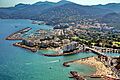
Mouth of the Siagne in Mandelieu-la-Napoule
-

Mouth of the Siagne in Mandelieu-la-Napoule


Related Pages
See also
 In Spanish: Río Siagne para niños
