
Drôme facts for kids
Quick facts for kids
Drôme
|
|||
|---|---|---|---|
.jpg)
Valence, capital of Drôme.
|
|||
|
|||

Location of Drôme in France
|
|||
| Country | France | ||
| Region | Auvergne-Rhône-Alpes | ||
| Département | 4 March 1790 | ||
| Prefecture | Valence | ||
| Subprefectures | Die, Nyons | ||
| Area | |||
| • Total | 6,530.0 km2 (2,521.2 sq mi) | ||
| Population
(2014)
|
|||
| • Total | 499,159 | ||
| • Rank | 33 | ||
| • Density | 76.4409/km2 (197.9810/sq mi) | ||
| Demonym(s) | Drômois | ||
| Time zone | UTC+1 (CET) | ||
| • Summer (DST) | UTC+2 (CEST) | ||
| ISO 3166 code | FR-26 | ||
| Arrondissements | 3 | ||
| Cantons | 19 | ||
| Communes | 367 | ||
| Website | http://www.ladrome.fr/ | ||


The Drôme (pronounced "Drom") is a special area in southeastern France. It's called a "department" and is part of the Auvergne-Rhône-Alpes region. The department gets its name from the Drôme River that flows through it. Its main city, or "prefecture," is Valence.
Contents
History of Drôme
The Drôme department was created a long time ago, on March 4, 1790. This happened during the French Revolution, a big change in France's history. It was made from a part of an older French area called Dauphiné.
When it was first made, Drôme had six smaller areas called "districts." These were Romans, Valence, Die, Buis, Montélimar, and Crest. The first main city was Chabeuil, but in the same year, the capital moved to Valence.
Later, these districts were changed into four "arrondissements" (which are like administrative zones): Valence, Die, Montélimar, and Nyons. In 1926, the Montélimar arrondissement was removed.
Geography and Landscape
Drôme is located in southeastern France and is part of the Auvergne-Rhône-Alpes region. It covers an area of about 6,530 square kilometers (2,521 square miles).
Neighboring Areas
The department shares its borders with five other departments:
- In the Provence-Alpes-Côte d'Azur region:
- Hautes-Alpes to the east
- Alpes-de-Haute-Provence to the southeast
- Vaucluse to the south
- In the Auvergne-Rhône-Alpes region:
 |
Isère | |
||
| Ardèche | Isère Hautes-Alpes |
|||
| Vaucluse | Alpes-de-Haute-Provence |
Natural Regions
Drôme has five different natural areas, moving from north to south:
- A region with gentle hills.
- The flat plain of Valence in the west.
- The Vercors Massif (a group of mountains) to the east.
- The central part, which includes the valley of the Drôme river and the department's highest mountains.
- The Drôme provençale in the south, which has a feel of the Provence region.
The highest point in Drôme is a peak called Rocher Rond. It stands at 2,453 meters (8,048 feet) tall and is located on the border with the Hautes-Alpes department.
Main Rivers
Several important rivers flow through Drôme:
- The Rhône River runs along the western side of the department for about 108 kilometers (67 miles).
- The Drôme River is a smaller river that eventually flows into the Rhône.
- The Isère River is another river that joins the Rhône.
Climate in Drôme
The climate in Drôme, especially around the city of Valence, is an oceanic climate. This means it has mild temperatures and rainfall throughout the year.
In Valence, the average yearly temperature is about 12.8°C (55°F). July is usually the warmest month, with an average of 22.2°C (72°F). January is the coolest, averaging 3.9°C (39°F).
The department gets about 845.8 millimeters (33.3 inches) of rain each year. September is typically the wettest month, while February is the driest.
How Drôme is Governed
Drôme is part of the Auvergne-Rhône-Alpes region. The department is managed by a group called the Departmental Council of the Drôme, which is based in Valence.
Administrative Divisions
Drôme is divided into smaller administrative areas to help manage it. These include:
- 3 arrondissements (larger districts)
- 19 cantons (smaller electoral divisions)
- 367 communes (individual towns or villages)
Here's a quick look at the main arrondissements:
| INSEE code |
Arrondissement | Capital | Population (2014) |
Area (km²) |
Density (Inh./km²) |
Communes |
|---|---|---|---|---|---|---|
| 261 | Die | Die | 42,955 | 2,286.9 | 18.8 | 113 |
| 262 | Nyons | Nyons | 141,971 | 2,358.7 | 60.2 | 149 |
| 263 | Valence | Valence | 314,233 | 1,884.4 | 166.8 | 105 |
Population of Drôme
People who live in Drôme are called Drômois (for men) or Drômoises (for women).
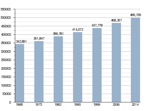
In 2014, Drôme had a population of 499,159 people. This means there were about 76 people living in each square kilometer. The arrondissement of Valence is the most populated, with 314,233 people. The other two, Nyons and Die, have 141,971 and 42,955 people, respectively.
The largest city in the department is its capital, Valence, with 62,150 inhabitants. The subprefectures of Nyons and Die are smaller, with 6,641 and 4,516 inhabitants.
Evolution of the population in Drôme
Here are the 10 most populated cities in Drôme:
| City | Population (2014) |
Arrondissement |
|---|---|---|
| Valence | 62,150 | Valence |
| Montélimar | 37,193 | Nyons |
| Romans-sur-Isère | 33,366 | Valence |
| Bourg-lès-Valence | 19,591 | Valence |
| Pierrelatte | 13,071 | Nyons |
| Bourg-de-Péage | 10,171 | Valence |
| Portes-lès-Valence | 9,973 | Valence |
| Saint-Paul-Trois-Châteaux | 8,944 | Nyons |
| Livron-sur-Drôme | 8,927 | Die |
| Crest | 8,211 | Die |
Gallery


Related pages
Images for kids
-
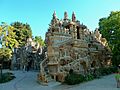
Ferdinand Cheval's palace
-
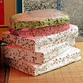
Nougat from Montélimar


See also
 In Spanish: Drôme para niños
