Arrondissement of Die facts for kids
Quick facts for kids
Arrondissement of Die
|
|
|---|---|

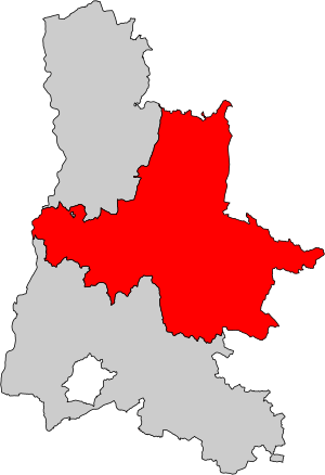
Location of the arrondissement Die in Drôme
|
|
| Country | France |
| Region | Auvergne-Rhône-Alpes |
| Department | Drôme |
| Communes | 113 |
| Subprefecture | Die |
| INSEE code | 261 |
| Area | |
| • Total | 2,286.9 km2 (883.0 sq mi) |
| Population
(2014)
|
|
| • Total | 42,955 |
| • Density | 18.7831/km2 (48.6479/sq mi) |
The arrondissement of Die is a special kind of administrative area in France. Think of it like a district or a county. It's located in the Drôme department, which is like a larger region. This department is part of the Auvergne-Rhône-Alpes region in southeastern France. The main town, or capital, of this arrondissement is Die.
Contents
A Look Back: History of Die Arrondissement
The Die arrondissement has been around for a long time. It was first created on February 17, 1800. This happened when the Drôme department, its larger administrative area, was also formed.
Where is Die Arrondissement? Geography Facts
The arrondissement of Die is located in the central-west part of the Drôme department. It covers a large area of about 2,286.9 square kilometers (882.97 square miles).
It is the arrondissement with the fewest people living in it. In 2014, about 42,955 people lived there. This means its population density is about 18.8 people per square kilometer. Population density tells us how many people live in a certain amount of space.
The Die arrondissement shares borders with other areas:
- To the north and west, it borders the Valence arrondissement.
- To the northeast, it borders the Isère department.
- To the south, it borders the Nyons arrondissement.
Understanding Die: Cantons and Communes
France is divided into smaller areas to help with local government. These areas are called cantons and communes.
Cantons: Local Voting Areas
Cantons are like voting districts. After a change in how cantons are organized in France, they can sometimes include towns that belong to different arrondissements.
The Die arrondissement has 5 cantons:
- Crest (partly)
- Dieulefit (partly)
- Le Diois
- Loriol-sur-Drôme (partly)
- Vercors-Monts du Matin (partly)
Communes: Towns and Villages
A commune is the smallest administrative division in France. It's like a town or a village. The arrondissement of Die has 113 communes.
Here are some of the communes with the most people living in them:
| INSEE code |
Commune | Population (2014) |
Canton | Intercommunality |
|---|---|---|---|---|
| 26165 | Livron-sur-Drôme | 8,927 | Loriol-sur-Drôme | Le Val de Drôme |
| 26108 | Crest | 8,211 | Crest | Le Crestois et du Pays de Saillans Cœur de Drôme |
| 26166 | Loriol-sur-Drôme | 6,305 | Loriol-sur-Drôme | Le Val de Drôme |
| 26113 | Die | 4,516 | Le Diois | Le Diois |
| 26006 | Allex | 2,463 | Loriol-sur-Drôme | Le Val de Drôme |
| 26011 | Aouste-sur-Sye | 2,436 | Crest | Le Crestois et du Pays de Saillans Cœur de Drôme |
| 26208 | Montoison | 1,889 | Loriol-sur-Drôme | Le Val de Drôme |
| 26144 | Grane | 1,858 | Crest | Le Val de Drôme |
| 26125 | Eurre | 1,262 | Crest | Le Val de Drôme |
| 26289 | Saillans | 1,231 | Le Diois | Le Crestois et du Pays de Saillans Cœur de Drôme |
| 26183 | Mirabel-et-Blacons | 1,007 | Crest | Le Crestois et du Pays de Saillans Cœur de Drôme |
Related pages
See also
 In Spanish: Distrito de Die para niños
 | Sharif Bey |
 | Hale Woodruff |
 | Richmond Barthé |
 | Purvis Young |

