
Savoie facts for kids
Quick facts for kids
Savoie
|
|||
|---|---|---|---|

Prefecture building of the Savoie department, in Chambéry
|
|||
|
|||

Location of Savoie in France
|
|||
| Country | France | ||
| Region | Auvergne-Rhône-Alpes | ||
| Département | 1860 | ||
| Prefecture | Chambéry | ||
| Subprefectures | Albertville, Saint-Jean-de-Maurienne | ||
| Area | |||
| • Total | 6,028.3 km2 (2,327.5 sq mi) | ||
| Population
(2014)
|
|||
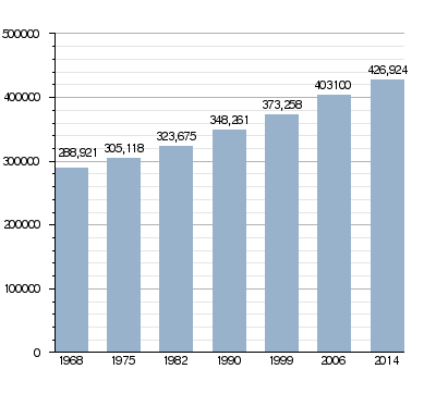
| • Total | 426,924 | ||
| • Density | 70.8200/km2 (183.4229/sq mi) | ||
| Demonym(s) | Savoyards | ||
| Time zone | UTC+1 (CET) | ||
| • Summer (DST) | UTC+2 (CEST) | ||
| ISO 3166 code | FR-73 | ||
| Arrondissements | 3 | ||
| Cantons | 19 | ||
| Communes | 285 | ||
| Website | www.savoie.fr | ||


Savoie is a cool place in southeastern France, right next to Italy. It's a "département," which is like a county, in the Auvergne-Rhône-Alpes region.
Contents
What's in a Name?
Before 1860, the area we now call Savoie and Haute-Savoie was part of the Kingdom of Sardinia. It was a special region called a Duchy since 1713.
In 1860, this area became part of France. The Emperor Napoléon III then split it into two "départements." The southern part, with the city of Chambéry, became Savoie. The northern part, with the city of Annecy, became Haute-Savoie.
A Look Back at Savoie's History
The Savoie département was officially created in 1860. It was formed from the southern part of the Duchy of Sardinia.
It started with four main areas called arrondissements: Chambéry, Albertville, Moûtiers, and Saint-Jean-de-Maurienne. The main city, or capital, was Chambéry.
Later, in 1926, the arrondissement of Moûtiers was removed.
During World War II, from November 1942 to September 1943, the department was under the control of Italy.
Exploring Savoie's Geography
Savoie is part of the Auvergne-Rhône-Alpes region in France. It covers an area of about 6,028 square kilometers (2,327 square miles).
This department shares its borders with several other French departments: Ain, Isère, and Haute-Savoie in its own region. It also borders Hautes-Alpes in the Provence-Alpes-Côte d'Azur region. Plus, it has a border with Italy, specifically the Piedmont region.
 |
Ain | Haute-Savoie | Italy | |
| Isère | Italy | |||
| Isère | Hautes-Alpes | Italy |
Most of Savoie is covered by mountains, which are part of the Alps. The tallest mountain here is La Grande Casse, standing at 3,855 meters (12,648 feet) high.
The main rivers in Savoie are the Isère and its smaller river, the Arch. Both flow from east to west through the department. They eventually join the Rhône river. The biggest lake in Savoie is Lac du Bourget, which is also the largest and deepest lake entirely within France.
Savoie's Climate
The weather in Savoie, especially around Chambéry, is known as an "Oceanic climate." This means it has mild temperatures and rainfall throughout the year.
How Savoie is Governed
Savoie is managed by the Departmental Council of Savoie, which is located in Chambéry. This department is part of the larger Auvergne-Rhône-Alpes region.
Savoie is also a member of the UNPO (Unrepresented Nations and Peoples Organization). This group helps connect different nations and peoples who might not have a voice on the world stage.
Savoie's Administrative Areas
Savoie is divided into 3 main arrondissements (like districts). These are further split into 19 cantons and 285 communes (which are like small towns or municipalities).
| District | Main City | Population (2014) |
Area (km²) |
Number of Towns |
|---|---|---|---|---|
| Albertville | Albertville | 111,839 | 2,466.1 | 74 |
| Chambéry | Chambéry | 271,647 | 1,586.1 | 155 |
| Saint-Jean-de-Maurienne | Saint-Jean-de-Maurienne | 43,438 | 1,976.0 | 56 |
Here are the 19 cantons of the Savoie department, which were reorganized in March 2015:
- Aix-les-Bains-1
- Aix-les-Bains-2
- Albertville-1
- Albertville-2
- Bourg-Saint-Maurice
- Bugey savoyard
- Chambéry-1
- Chambéry-2
- Chambéry-3
- Modane
- Montmélian
- La Motte-Servolex
- Moûtiers
- Le Pont-de-Beauvoisin
- La Ravoire
- Saint-Alban-Leysse
- Saint-Jean-de-Maurienne
- Saint-Pierre-d'Albigny
- Ugine
People of Savoie
The people who live in Savoie are called Savoyards (or Savoyardes for women) in French.
In 2014, Savoie had a population of 426,924 people. This means there were about 71 people living in each square kilometer. The district of Chambéry is the most populated, with 271,647 residents.
How the Population of Savoie Has Grown
Here are some of the largest towns (communes) in Savoie, based on their population in 2014:
| City | Population (2014) |
District |
|---|---|---|
| Chambéry | 59,490 | Chambéry |
| Aix-les-Bains | 30,291 | Chambéry |
| Albertville | 18,950 | Albertville |
| La Motte-Servolex | 11,726 | Chambéry |
| La Ravoire | 8,032 | Chambéry |
| Saint-Jean-de-Maurienne | 7,889 | Saint-Jean-de-Maurienne |
| Bourg-Saint-Maurice | 7,204 | Albertville |
| Ugine | 7,019 | Albertville |
| Cognin | 6,027 | Chambéry |
| Entrelacs | 5,920 | Chambéry |
Gallery
-
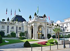
Casino of Aix-les-Bains.
-
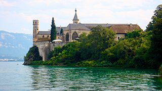
Hautecombe Abbey on the Lac du Bourget.


Related Pages
Images for kids
-
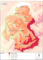
Relief map of Savoy
-
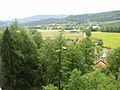
Low elevation: the Savoie frontcountry
-
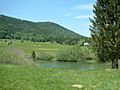
Mid elevation: Mariet plateau in the Bauges Massif
-
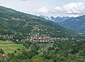
High elevation: the village of Aime
-
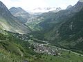
Bonneval-sur-Arc in the Maurienne valley
-
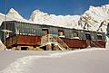
Refuge of the Aiguilles d'Arves
-
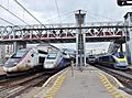
Trains in Savoie


.JPG)


.JPG)
See also
 In Spanish: Saboya (departamento) para niños
